
Size of this preview:
589 × 600 pixels. Other resolutions:
236 × 240 pixels |
471 × 480 pixels |
755 × 769 pixels.
Original file (755 × 769 pixels, file size: 167 KB, MIME type: image/jpeg)
| This is a file from the
Wikimedia Commons. Information from its
description page there is shown below. Commons is a freely licensed media file repository. You can help. |
Summary
| Description |
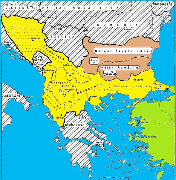
English: Ottoman Empire Balkan vilayets |
| Date | 2 October 2010 (original upload date) |
| Source | Scanned map and digitally colored |
| Author | Byzerodivide at en.wikipedia |
Licensing
This media file is in the
public domain in the
United States. This applies to U.S. works where the copyright has expired, often because its first
publication occurred prior to January 1, 1929, and if not then due to lack of notice or renewal. See
this page for further explanation.
|
 | |
 |
This image might not be in the public domain outside of the United States; this especially applies in the countries and areas that do not apply the
rule of the shorter term for US works, such as Canada, Mainland China (not Hong Kong or Macao), Germany, Mexico, and Switzerland. The creator and year of publication are essential information and must be provided. See
Wikipedia:Public domain and
Wikipedia:Copyrights for more details.
|
Original upload log
The original description page was
here. All following user names refer to en.wikipedia.
- 2010-10-02 18:21 Byzerodivide 755×769× (170620 bytes)
File history
Click on a date/time to view the file as it appeared at that time.
| Date/Time | Thumbnail | Dimensions | User | Comment | |
|---|---|---|---|---|---|
| current | 06:23, 7 April 2011 |
| 755 × 769 (167 KB) | Urdangaray | {{Information |Description={{en|Ottoman Empire Balkan vilayets<br/> == License information == en:Category:Maps of the Ottoman Empire}} |Source=Transferred from [http://en.wikipedia.org en.wikipedia]<br/> (Original text : ''Scanned map and digitally |
File usage
No pages on the English Wikipedia use this file (pages on other projects are not listed).
Global file usage
The following other wikis use this file:
- Usage on es.wikipedia.org
Metadata
Size of this preview:
589 × 600 pixels. Other resolutions:
236 × 240 pixels |
471 × 480 pixels |
755 × 769 pixels.
Original file (755 × 769 pixels, file size: 167 KB, MIME type: image/jpeg)
| This is a file from the
Wikimedia Commons. Information from its
description page there is shown below. Commons is a freely licensed media file repository. You can help. |
Summary
| Description |
English: Ottoman Empire Balkan vilayets |
| Date | 2 October 2010 (original upload date) |
| Source | Scanned map and digitally colored |
| Author | Byzerodivide at en.wikipedia |
Licensing
This media file is in the
public domain in the
United States. This applies to U.S. works where the copyright has expired, often because its first
publication occurred prior to January 1, 1929, and if not then due to lack of notice or renewal. See
this page for further explanation.
|
| |
|
This image might not be in the public domain outside of the United States; this especially applies in the countries and areas that do not apply the
rule of the shorter term for US works, such as Canada, Mainland China (not Hong Kong or Macao), Germany, Mexico, and Switzerland. The creator and year of publication are essential information and must be provided. See
Wikipedia:Public domain and
Wikipedia:Copyrights for more details.
|
Original upload log
The original description page was
here. All following user names refer to en.wikipedia.
- 2010-10-02 18:21 Byzerodivide 755×769× (170620 bytes)
File history
Click on a date/time to view the file as it appeared at that time.
| Date/Time | Thumbnail | Dimensions | User | Comment | |
|---|---|---|---|---|---|
| current | 06:23, 7 April 2011 |
| 755 × 769 (167 KB) | Urdangaray | {{Information |Description={{en|Ottoman Empire Balkan vilayets<br/> == License information == en:Category:Maps of the Ottoman Empire}} |Source=Transferred from [http://en.wikipedia.org en.wikipedia]<br/> (Original text : ''Scanned map and digitally |
File usage
No pages on the English Wikipedia use this file (pages on other projects are not listed).
Global file usage
The following other wikis use this file:
- Usage on es.wikipedia.org