
Size of this PNG preview of this SVG file:
800 × 457 pixels. Other resolutions:
320 × 183 pixels |
640 × 366 pixels |
1,024 × 585 pixels |
1,280 × 731 pixels |
2,560 × 1,463 pixels |
1,400 × 800 pixels.
Original file (SVG file, nominally 1,400 × 800 pixels, file size: 1.62 MB)
| This is a file from the
Wikimedia Commons. Information from its
description page there is shown below. Commons is a freely licensed media file repository. You can help. |
Summary
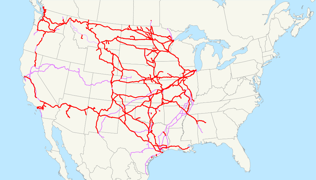
| Description | This is a map of the BNSF Railway as of 2009, with trackage rights in purple ( haulage rights are lighter). Email me if you would like a copy of the GIS data I created (modified from Bureau of Transportation Statistics North American Transportation Atlas Data) or if you see any errors. |
| Date | 23 February 2009 (original upload date) |
| Source | No machine-readable source provided. Own work assumed (based on copyright claims). |
| Author | No machine-readable author provided. NE2 assumed (based on copyright claims). |
Licensing
| I, the copyright holder of this work, release this work into the
public domain. This applies worldwide. In some countries this may not be legally possible; if so: I grant anyone the right to use this work for any purpose, without any conditions, unless such conditions are required by law. |
File history
Click on a date/time to view the file as it appeared at that time.
| Date/Time | Thumbnail | Dimensions | User | Comment | |
|---|---|---|---|---|---|
| current | 05:14, 25 October 2022 |
| 1,400 × 800 (1.62 MB) | Fluffy89502 | Tracks south of Fullerton, CA has been owned by the State of California prior to 2009 |
| 13:03, 23 February 2009 |
 | 1,400 × 800 (1.51 MB) | NE2 | == Summary == This is a map of the BNSF Railway as of 2009, with trackage rights in purple ( haulage rights are lighter). Email me if you would like a copy of the GIS data I created (mod |
File usage
More than 100 pages use this file. The following list shows the first 100 pages that use this file only. A full list is available.
- BNSF Railway
- Talk:Arriva Midlands
- Talk:Arriva Midlands East
- Talk:Barr Subdivision
- Talk:Blackburn Bus Company
- Talk:Bristol park and ride
- Talk:Cavendish Motor Services
- Talk:Central Maryland Regional Transit
- Talk:Chattanooga Area Regional Transportation Authority
- Talk:CityLink Gold (BaltimoreLink)
- Talk:CityLink Lime (BaltimoreLink)
- Talk:CityLink Orange (BaltimoreLink)
- Talk:CityLink Pink (BaltimoreLink)
- Talk:CityLink Red (BaltimoreLink)
- Talk:CityLink Yellow (BaltimoreLink)
- Talk:Crosville Motor Services
- Talk:First Eastern Counties
- Talk:First West of England
- Talk:First Worcester
- Talk:Garrett Subdivision
- Talk:Lancashire United Transport
- Talk:LocalLink 21 (BaltimoreLink)
- Talk:LocalLink 22 (BaltimoreLink)
- Talk:LocalLink 28 (BaltimoreLink)
- Talk:LocalLink 29 (BaltimoreLink)
- Talk:LocalLink 30 (BaltimoreLink)
- Talk:LocalLink 31 (BaltimoreLink)
- Talk:LocalLink 33 (BaltimoreLink)
- Talk:LocalLink 36 (BaltimoreLink)
- Talk:LocalLink 37 (BaltimoreLink)
- Talk:LocalLink 54 (BaltimoreLink)
- Talk:LocalLink 56 (BaltimoreLink)
- Talk:LocalLink 57 (BaltimoreLink)
- Talk:LocalLink 59 (BaltimoreLink)
- Talk:LocalLink 67 (BaltimoreLink)
- Talk:LocalLink 70 (BaltimoreLink)
- Talk:LocalLink 73 (BaltimoreLink)
- Talk:LocalLink 75 (BaltimoreLink)
- Talk:LocalLink 78 (BaltimoreLink)
- Talk:LocalLink 80 (BaltimoreLink)
- Talk:LocalLink 82 (BaltimoreLink)
- Talk:LocalLink 83 (BaltimoreLink)
- Talk:LocalLink 85 (BaltimoreLink)
- Talk:LocalLink 87 (BaltimoreLink)
- Talk:LocalLink 89 (BaltimoreLink)
- Talk:LocalLink 92 (BaltimoreLink)
- Talk:LocalLink 93 (BaltimoreLink)
- Talk:LocalLink 94 (BaltimoreLink)
- Talk:LocalLink 95 (BaltimoreLink)
- Talk:Metro (Belfast)
- Talk:Michael Cobb (railway historian)
- Talk:Noctilien
- Talk:Optile
- Talk:Oxford Bus Company
- Talk:Passenger transport executive
- Talk:QuickLink 40 (BaltimoreLink)
- Talk:Red & White Services
- Talk:Ribble Motor Services
- Talk:Route 150 (MTA Maryland)
- Talk:Route 15 (MTA Maryland)
- Talk:Route 160 (MTA Maryland)
- Talk:Route 21 (MTA Maryland)
- Talk:Route 29 (MTA Maryland)
- Talk:Route 30 (MTA Maryland)
- Talk:Route 310 (MTA Maryland)
- Talk:Route 46 (MTA Quickbus)
- Talk:Route 47 (MTA Quickbus)
- Talk:Route 48 (MTA Maryland)
- Talk:Route 7 (MTA Maryland)
- Talk:Route 991 (MTA Maryland)
- Talk:Scottish Bus Group
- Talk:Stagecoach West
- Talk:Stagecoach in Lincolnshire
- Talk:Stagecoach in Warwickshire
- Talk:Thomson–East Coast MRT line
- Talk:Ulsterbus
- Talk:United Automobile Services
- Talk:West Yorkshire Road Car Company
- Talk:Western SMT
- Talk:Yarmouth bus station
- Wikipedia:WikiProject Trains/Maps task force
- Wikipedia talk:WikiProject Trains/Maps task force
- File talk:Lyttelton Line map.png
- File talk:Mgnjrbourne01.jpg
- File talk:Mgnjrsig01.jpg
- File talk:Northisland NZ East-Coast-Main-Trunk.png
- File talk:Northisland NZ NIMT.png
- File talk:Queen city map.jpg
- Template:WikiProject Buses
- Template:WikiProject Buses/sandbox
- Template:WikiProject Trains
- Template:WikiProject Trains/sandbox
- Template:WikiProject Trains/testcases
- Template talk:DLR RDT
- Template talk:Disneyland Resort line RDT
- Template talk:Eurostar
- Category:New York City public transportation articles needing maps
- Category:Trains project maps task force articles
- Category talk:Rail transport articles needing maps
- Category talk:Railroad maps
View more links to this file.
Global file usage
The following other wikis use this file:
- Usage on da.wikipedia.org
- Usage on de.wikipedia.org
- Usage on eo.wikipedia.org
- Usage on es.wikipedia.org
- Usage on fa.wikipedia.org
- Usage on fr.wikipedia.org
- Usage on hu.wikipedia.org
- Usage on id.wikipedia.org
- Usage on it.wikipedia.org
- Usage on ja.wikipedia.org
- Usage on ko.wikipedia.org
- Usage on ms.wikipedia.org
- Usage on nl.wikipedia.org
- Usage on pl.wikipedia.org
- Usage on pt.wikipedia.org
- Usage on ru.wikipedia.org
- Usage on sk.wikipedia.org
- Usage on sl.wikipedia.org
- Usage on sv.wikipedia.org
- Usage on www.wikidata.org
- Usage on zh.wikipedia.org
Metadata
Size of this PNG preview of this SVG file:
800 × 457 pixels. Other resolutions:
320 × 183 pixels |
640 × 366 pixels |
1,024 × 585 pixels |
1,280 × 731 pixels |
2,560 × 1,463 pixels |
1,400 × 800 pixels.
Original file (SVG file, nominally 1,400 × 800 pixels, file size: 1.62 MB)
| This is a file from the
Wikimedia Commons. Information from its
description page there is shown below. Commons is a freely licensed media file repository. You can help. |
Summary
| Description | This is a map of the BNSF Railway as of 2009, with trackage rights in purple ( haulage rights are lighter). Email me if you would like a copy of the GIS data I created (modified from Bureau of Transportation Statistics North American Transportation Atlas Data) or if you see any errors. |
| Date | 23 February 2009 (original upload date) |
| Source | No machine-readable source provided. Own work assumed (based on copyright claims). |
| Author | No machine-readable author provided. NE2 assumed (based on copyright claims). |
Licensing
| I, the copyright holder of this work, release this work into the
public domain. This applies worldwide. In some countries this may not be legally possible; if so: I grant anyone the right to use this work for any purpose, without any conditions, unless such conditions are required by law. |
File history
Click on a date/time to view the file as it appeared at that time.
| Date/Time | Thumbnail | Dimensions | User | Comment | |
|---|---|---|---|---|---|
| current | 05:14, 25 October 2022 |
| 1,400 × 800 (1.62 MB) | Fluffy89502 | Tracks south of Fullerton, CA has been owned by the State of California prior to 2009 |
| 13:03, 23 February 2009 |
| 1,400 × 800 (1.51 MB) | NE2 | == Summary == This is a map of the BNSF Railway as of 2009, with trackage rights in purple ( haulage rights are lighter). Email me if you would like a copy of the GIS data I created (mod |
File usage
More than 100 pages use this file. The following list shows the first 100 pages that use this file only. A full list is available.
- BNSF Railway
- Talk:Arriva Midlands
- Talk:Arriva Midlands East
- Talk:Barr Subdivision
- Talk:Blackburn Bus Company
- Talk:Bristol park and ride
- Talk:Cavendish Motor Services
- Talk:Central Maryland Regional Transit
- Talk:Chattanooga Area Regional Transportation Authority
- Talk:CityLink Gold (BaltimoreLink)
- Talk:CityLink Lime (BaltimoreLink)
- Talk:CityLink Orange (BaltimoreLink)
- Talk:CityLink Pink (BaltimoreLink)
- Talk:CityLink Red (BaltimoreLink)
- Talk:CityLink Yellow (BaltimoreLink)
- Talk:Crosville Motor Services
- Talk:First Eastern Counties
- Talk:First West of England
- Talk:First Worcester
- Talk:Garrett Subdivision
- Talk:Lancashire United Transport
- Talk:LocalLink 21 (BaltimoreLink)
- Talk:LocalLink 22 (BaltimoreLink)
- Talk:LocalLink 28 (BaltimoreLink)
- Talk:LocalLink 29 (BaltimoreLink)
- Talk:LocalLink 30 (BaltimoreLink)
- Talk:LocalLink 31 (BaltimoreLink)
- Talk:LocalLink 33 (BaltimoreLink)
- Talk:LocalLink 36 (BaltimoreLink)
- Talk:LocalLink 37 (BaltimoreLink)
- Talk:LocalLink 54 (BaltimoreLink)
- Talk:LocalLink 56 (BaltimoreLink)
- Talk:LocalLink 57 (BaltimoreLink)
- Talk:LocalLink 59 (BaltimoreLink)
- Talk:LocalLink 67 (BaltimoreLink)
- Talk:LocalLink 70 (BaltimoreLink)
- Talk:LocalLink 73 (BaltimoreLink)
- Talk:LocalLink 75 (BaltimoreLink)
- Talk:LocalLink 78 (BaltimoreLink)
- Talk:LocalLink 80 (BaltimoreLink)
- Talk:LocalLink 82 (BaltimoreLink)
- Talk:LocalLink 83 (BaltimoreLink)
- Talk:LocalLink 85 (BaltimoreLink)
- Talk:LocalLink 87 (BaltimoreLink)
- Talk:LocalLink 89 (BaltimoreLink)
- Talk:LocalLink 92 (BaltimoreLink)
- Talk:LocalLink 93 (BaltimoreLink)
- Talk:LocalLink 94 (BaltimoreLink)
- Talk:LocalLink 95 (BaltimoreLink)
- Talk:Metro (Belfast)
- Talk:Michael Cobb (railway historian)
- Talk:Noctilien
- Talk:Optile
- Talk:Oxford Bus Company
- Talk:Passenger transport executive
- Talk:QuickLink 40 (BaltimoreLink)
- Talk:Red & White Services
- Talk:Ribble Motor Services
- Talk:Route 150 (MTA Maryland)
- Talk:Route 15 (MTA Maryland)
- Talk:Route 160 (MTA Maryland)
- Talk:Route 21 (MTA Maryland)
- Talk:Route 29 (MTA Maryland)
- Talk:Route 30 (MTA Maryland)
- Talk:Route 310 (MTA Maryland)
- Talk:Route 46 (MTA Quickbus)
- Talk:Route 47 (MTA Quickbus)
- Talk:Route 48 (MTA Maryland)
- Talk:Route 7 (MTA Maryland)
- Talk:Route 991 (MTA Maryland)
- Talk:Scottish Bus Group
- Talk:Stagecoach West
- Talk:Stagecoach in Lincolnshire
- Talk:Stagecoach in Warwickshire
- Talk:Thomson–East Coast MRT line
- Talk:Ulsterbus
- Talk:United Automobile Services
- Talk:West Yorkshire Road Car Company
- Talk:Western SMT
- Talk:Yarmouth bus station
- Wikipedia:WikiProject Trains/Maps task force
- Wikipedia talk:WikiProject Trains/Maps task force
- File talk:Lyttelton Line map.png
- File talk:Mgnjrbourne01.jpg
- File talk:Mgnjrsig01.jpg
- File talk:Northisland NZ East-Coast-Main-Trunk.png
- File talk:Northisland NZ NIMT.png
- File talk:Queen city map.jpg
- Template:WikiProject Buses
- Template:WikiProject Buses/sandbox
- Template:WikiProject Trains
- Template:WikiProject Trains/sandbox
- Template:WikiProject Trains/testcases
- Template talk:DLR RDT
- Template talk:Disneyland Resort line RDT
- Template talk:Eurostar
- Category:New York City public transportation articles needing maps
- Category:Trains project maps task force articles
- Category talk:Rail transport articles needing maps
- Category talk:Railroad maps
View more links to this file.
Global file usage
The following other wikis use this file:
- Usage on da.wikipedia.org
- Usage on de.wikipedia.org
- Usage on eo.wikipedia.org
- Usage on es.wikipedia.org
- Usage on fa.wikipedia.org
- Usage on fr.wikipedia.org
- Usage on hu.wikipedia.org
- Usage on id.wikipedia.org
- Usage on it.wikipedia.org
- Usage on ja.wikipedia.org
- Usage on ko.wikipedia.org
- Usage on ms.wikipedia.org
- Usage on nl.wikipedia.org
- Usage on pl.wikipedia.org
- Usage on pt.wikipedia.org
- Usage on ru.wikipedia.org
- Usage on sk.wikipedia.org
- Usage on sl.wikipedia.org
- Usage on sv.wikipedia.org
- Usage on www.wikidata.org
- Usage on zh.wikipedia.org