
Size of this preview:
800 × 474 pixels. Other resolutions:
320 × 190 pixels |
640 × 380 pixels |
870 × 516 pixels.
Original file (870 × 516 pixels, file size: 17 KB, MIME type: image/png)
| This is a file from the
Wikimedia Commons. Information from its
description page there is shown below. Commons is a freely licensed media file repository. You can help. |
Summary
| Description |
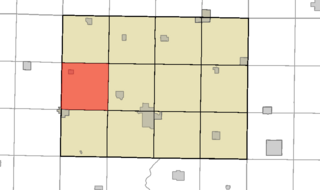
English: This is a map of
Humboldt County, Iowa, USA which highlights the location of
Avery Township. |
| Date | |
| Source | My own work, using National Atlas and United States Census Bureau data |
| Author | Brandonrush ( talk) |
Licensing
| I, the copyright holder of this work, release this work into the
public domain. This applies worldwide. In some countries this may not be legally possible; if so: I grant anyone the right to use this work for any purpose, without any conditions, unless such conditions are required by law. |
File history
Click on a date/time to view the file as it appeared at that time.
| Date/Time | Thumbnail | Dimensions | User | Comment | |
|---|---|---|---|---|---|
| current | 02:21, 22 March 2011 |
| 870 × 516 (17 KB) | Brandonrush | Inexplicably left off Hardy, IA |
| 21:17, 7 December 2010 |
 | 870 × 516 (17 KB) | Brandonrush | == {{int:filedesc}} == {{Information |Description={{en|This is a map of Humboldt County, Iowa, USA which highlights the location of Avery Township.}} |Source=My own work, using [htt |
File usage
The following pages on the English Wikipedia use this file (pages on other projects are not listed):
Global file usage
The following other wikis use this file:
- Usage on eu.wikipedia.org
- Usage on fr.wikipedia.org
- Usage on ja.wikipedia.org
- Usage on ur.wikipedia.org
- Usage on vi.wikipedia.org
- Usage on www.wikidata.org
- Usage on zh.wikipedia.org
Size of this preview:
800 × 474 pixels. Other resolutions:
320 × 190 pixels |
640 × 380 pixels |
870 × 516 pixels.
Original file (870 × 516 pixels, file size: 17 KB, MIME type: image/png)
| This is a file from the
Wikimedia Commons. Information from its
description page there is shown below. Commons is a freely licensed media file repository. You can help. |
Summary
| Description |
English: This is a map of
Humboldt County, Iowa, USA which highlights the location of
Avery Township. |
| Date | |
| Source | My own work, using National Atlas and United States Census Bureau data |
| Author | Brandonrush ( talk) |
Licensing
| I, the copyright holder of this work, release this work into the
public domain. This applies worldwide. In some countries this may not be legally possible; if so: I grant anyone the right to use this work for any purpose, without any conditions, unless such conditions are required by law. |
File history
Click on a date/time to view the file as it appeared at that time.
| Date/Time | Thumbnail | Dimensions | User | Comment | |
|---|---|---|---|---|---|
| current | 02:21, 22 March 2011 |
| 870 × 516 (17 KB) | Brandonrush | Inexplicably left off Hardy, IA |
| 21:17, 7 December 2010 |
| 870 × 516 (17 KB) | Brandonrush | == {{int:filedesc}} == {{Information |Description={{en|This is a map of Humboldt County, Iowa, USA which highlights the location of Avery Township.}} |Source=My own work, using [htt |
File usage
The following pages on the English Wikipedia use this file (pages on other projects are not listed):
Global file usage
The following other wikis use this file:
- Usage on eu.wikipedia.org
- Usage on fr.wikipedia.org
- Usage on ja.wikipedia.org
- Usage on ur.wikipedia.org
- Usage on vi.wikipedia.org
- Usage on www.wikidata.org
- Usage on zh.wikipedia.org