Original file (566 × 784 pixels, file size: 923 KB, MIME type: image/png)
| This is a file from the
Wikimedia Commons. Information from its
description page there is shown below. Commons is a freely licensed media file repository. You can help. |
Summary
| Description |
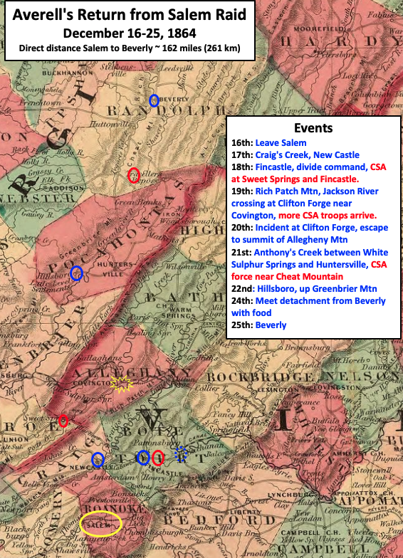
English: Map shows the return route used by Union Brigadier General William W. Averell after a raid on the Salem railroad depot during the American Civil War. He (blue) was pursued by multiple Confederate (red) forces, and almost half of his force narrowly escaped capture near Covington, Virginia. |
| Date | |
| Source | This is a crop of an 1864 map created by Alvin Jewett Johnson. The entire map can be found in the Library of Congress here, and shows Virginia, Delaware, Maryland & West Virginia. Text boxes and circles were added by TwoScarsUp based on descriptions in the books The Fourteenth Pennsylvania Cavalry in the Civil War by William Davis Slease and History of the Fifth West Virginia Cavalry, formerly the Second Virginia Infantry, and of Battery G, First West Virginia Light Artillery by Francis Smith Reader. |
| Author | Alvin Jewett Johnson (1827-1884) |
West Virginia and Virginia in the United States
Licensing
|
This work is in the public domain in its country of origin and other countries and areas where the copyright term is the author's life plus 70 years or fewer. This work is in the public domain in the United States because it was published (or registered with the U.S. Copyright Office) before January 1, 1929. | |
| This file has been identified as being free of known restrictions under copyright law, including all related and neighboring rights. | |
File history
Click on a date/time to view the file as it appeared at that time.
| Date/Time | Thumbnail | Dimensions | User | Comment | |
|---|---|---|---|---|---|
| current | 19:16, 9 July 2021 |
| 566 × 784 (923 KB) | TwoScarsUp | Uploaded a work by Alvin Jewett Johnson (1827-1884) from This is a crop of an 1864 map created by Alvin Jewett Johnson. The entire map can be found in the Library of Congress [https://www.loc.gov/item/lva0000096/ here], and shows Virginia, Delaware, Maryland & West Virginia. Text boxes and circles were added by TwoScarsUp based on descriptions in the books The Fourteenth Pennsylvania Cavalry in the Civil War by William Davis Slease and History of the Fifth West Virginia Cavalry, formerly the... |
File usage
Original file (566 × 784 pixels, file size: 923 KB, MIME type: image/png)
| This is a file from the
Wikimedia Commons. Information from its
description page there is shown below. Commons is a freely licensed media file repository. You can help. |
Summary
| Description |
English: Map shows the return route used by Union Brigadier General William W. Averell after a raid on the Salem railroad depot during the American Civil War. He (blue) was pursued by multiple Confederate (red) forces, and almost half of his force narrowly escaped capture near Covington, Virginia. |
| Date | |
| Source | This is a crop of an 1864 map created by Alvin Jewett Johnson. The entire map can be found in the Library of Congress here, and shows Virginia, Delaware, Maryland & West Virginia. Text boxes and circles were added by TwoScarsUp based on descriptions in the books The Fourteenth Pennsylvania Cavalry in the Civil War by William Davis Slease and History of the Fifth West Virginia Cavalry, formerly the Second Virginia Infantry, and of Battery G, First West Virginia Light Artillery by Francis Smith Reader. |
| Author | Alvin Jewett Johnson (1827-1884) |
West Virginia and Virginia in the United States
Licensing
|
This work is in the public domain in its country of origin and other countries and areas where the copyright term is the author's life plus 70 years or fewer. This work is in the public domain in the United States because it was published (or registered with the U.S. Copyright Office) before January 1, 1929. | |
| This file has been identified as being free of known restrictions under copyright law, including all related and neighboring rights. | |
File history
Click on a date/time to view the file as it appeared at that time.
| Date/Time | Thumbnail | Dimensions | User | Comment | |
|---|---|---|---|---|---|
| current | 19:16, 9 July 2021 |
| 566 × 784 (923 KB) | TwoScarsUp | Uploaded a work by Alvin Jewett Johnson (1827-1884) from This is a crop of an 1864 map created by Alvin Jewett Johnson. The entire map can be found in the Library of Congress [https://www.loc.gov/item/lva0000096/ here], and shows Virginia, Delaware, Maryland & West Virginia. Text boxes and circles were added by TwoScarsUp based on descriptions in the books The Fourteenth Pennsylvania Cavalry in the Civil War by William Davis Slease and History of the Fifth West Virginia Cavalry, formerly the... |