
Size of this PNG preview of this SVG file:
535 × 321 pixels. Other resolutions:
320 × 192 pixels |
640 × 384 pixels |
1,024 × 614 pixels |
1,280 × 768 pixels |
2,560 × 1,536 pixels.
Original file (SVG file, nominally 535 × 321 pixels, file size: 540 KB)
| This is a file from the
Wikimedia Commons. Information from its
description page there is shown below. Commons is a freely licensed media file repository. You can help. |
| Description |
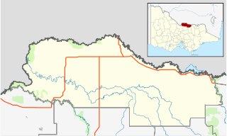
English: Blank map of
w:Moira Shire, Victoria, Australia, with the following information shown:
Geographic limits:
|
||
| Source | Own work + VicMap Lite | ||
| Author | Cassowary |

File history
Click on a date/time to view the file as it appeared at that time.
| Date/Time | Thumbnail | Dimensions | User | Comment | |
|---|---|---|---|---|---|
| current | 17:56, 18 February 2011 |
| 535 × 321 (540 KB) | Cassowary | {{Information |Description ={{en|1=Blank map of w:Moria Shire, Victoria, Australia, with the following information shown: * LGA boundaries * Coastline, lakes and rivers * Highways and freeways * Urban areas * Parks Geographic limits: * North: 35.6 |
File usage
The following pages on the English Wikipedia use this file (pages on other projects are not listed):
- Almonds, Victoria
- Barmah
- Bathumi
- Bearii
- Boomahnoomoonah
- Boosey, Victoria
- Boweya North
- Bundalong, Victoria
- Bundalong South
- Burramine
- Burramine South
- Cobram
- Cobram East
- Drumanure
- Esmond, Victoria
- Invergordon, Victoria
- Kaarimba
- Katamatite
- Katamatite East
- Katunga
- Koonoomoo
- Kotupna
- Lake Rowan
- Lower Moira
- Marungi
- Muckatah
- Mundoona
- Mywee
- Naring
- Nathalia, Victoria
- Numurkah
- Peechelba
- Pelluebla
- Picola
- Picola West
- Shire of Moira
- St James, Victoria
- Strathmerton
- Telford, Victoria
- Tungamah
- Ulupna
- Waaia
- Waggarandall
- Wilby, Victoria
- Wunghnu
- Yabba North
- Yabba South
- Yalca
- Yarrawonga
- Yarrawonga South
- Yarroweyah
- Yielima
- Youanmite
- Youarang
- Yundool
- User:ThylacineHunter/LGA
- User:Viatori/sandbox
- Template:Towns in Moira Shire
- Module:Location map/data/Australia Victoria Shire of Moira
- Module:Location map/data/Australia Victoria Shire of Moira/doc
Global file usage
The following other wikis use this file:
- Usage on ar.wikipedia.org
- Usage on ceb.wikipedia.org
- Usage on fa.wikipedia.org
- Usage on kn.wikipedia.org
- Usage on si.wikipedia.org
- Usage on tr.wikipedia.org
- Usage on ur.wikipedia.org
- Usage on uz.wikipedia.org
- Usage on war.wikipedia.org
Size of this PNG preview of this SVG file:
535 × 321 pixels. Other resolutions:
320 × 192 pixels |
640 × 384 pixels |
1,024 × 614 pixels |
1,280 × 768 pixels |
2,560 × 1,536 pixels.
Original file (SVG file, nominally 535 × 321 pixels, file size: 540 KB)
| This is a file from the
Wikimedia Commons. Information from its
description page there is shown below. Commons is a freely licensed media file repository. You can help. |
| Description |
English: Blank map of
w:Moira Shire, Victoria, Australia, with the following information shown:
Geographic limits:
|
||
| Source | Own work + VicMap Lite | ||
| Author | Cassowary |
File history
Click on a date/time to view the file as it appeared at that time.
| Date/Time | Thumbnail | Dimensions | User | Comment | |
|---|---|---|---|---|---|
| current | 17:56, 18 February 2011 |
| 535 × 321 (540 KB) | Cassowary | {{Information |Description ={{en|1=Blank map of w:Moria Shire, Victoria, Australia, with the following information shown: * LGA boundaries * Coastline, lakes and rivers * Highways and freeways * Urban areas * Parks Geographic limits: * North: 35.6 |
File usage
The following pages on the English Wikipedia use this file (pages on other projects are not listed):
- Almonds, Victoria
- Barmah
- Bathumi
- Bearii
- Boomahnoomoonah
- Boosey, Victoria
- Boweya North
- Bundalong, Victoria
- Bundalong South
- Burramine
- Burramine South
- Cobram
- Cobram East
- Drumanure
- Esmond, Victoria
- Invergordon, Victoria
- Kaarimba
- Katamatite
- Katamatite East
- Katunga
- Koonoomoo
- Kotupna
- Lake Rowan
- Lower Moira
- Marungi
- Muckatah
- Mundoona
- Mywee
- Naring
- Nathalia, Victoria
- Numurkah
- Peechelba
- Pelluebla
- Picola
- Picola West
- Shire of Moira
- St James, Victoria
- Strathmerton
- Telford, Victoria
- Tungamah
- Ulupna
- Waaia
- Waggarandall
- Wilby, Victoria
- Wunghnu
- Yabba North
- Yabba South
- Yalca
- Yarrawonga
- Yarrawonga South
- Yarroweyah
- Yielima
- Youanmite
- Youarang
- Yundool
- User:ThylacineHunter/LGA
- User:Viatori/sandbox
- Template:Towns in Moira Shire
- Module:Location map/data/Australia Victoria Shire of Moira
- Module:Location map/data/Australia Victoria Shire of Moira/doc
Global file usage
The following other wikis use this file:
- Usage on ar.wikipedia.org
- Usage on ceb.wikipedia.org
- Usage on fa.wikipedia.org
- Usage on kn.wikipedia.org
- Usage on si.wikipedia.org
- Usage on tr.wikipedia.org
- Usage on ur.wikipedia.org
- Usage on uz.wikipedia.org
- Usage on war.wikipedia.org