
Size of this PNG preview of this SVG file:
800 × 563 pixels. Other resolutions:
320 × 225 pixels |
640 × 450 pixels |
1,024 × 720 pixels |
1,280 × 900 pixels |
2,560 × 1,800 pixels |
1,375 × 967 pixels.
Original file (SVG file, nominally 1,375 × 967 pixels, file size: 313 KB)
| This is a file from the
Wikimedia Commons. Information from its
description page there is shown below. Commons is a freely licensed media file repository. You can help. |
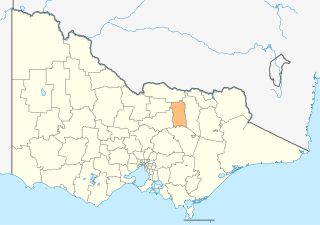
| Description | Victoria Australia Equirectangular projection, N/S stretching 124 %. Geographic limits of the map: * N: 33.8° S * S: 39.3° S * W: 140.6° E * E: 150.3° E |
| Date | |
| Source | |
| Author |
|
I, the copyright holder of this work, hereby publish it under the following license:
This file is licensed under the
Creative Commons
Attribution-Share Alike 3.0 Unported license.
- You are free:
- to share – to copy, distribute and transmit the work
- to remix – to adapt the work
- Under the following conditions:
- attribution – You must give appropriate credit, provide a link to the license, and indicate if changes were made. You may do so in any reasonable manner, but not in any way that suggests the licensor endorses you or your use.
- share alike – If you remix, transform, or build upon the material, you must distribute your contributions under the same or compatible license as the original.
File history
Click on a date/time to view the file as it appeared at that time.
| Date/Time | Thumbnail | Dimensions | User | Comment | |
|---|---|---|---|---|---|
| current | 00:09, 17 February 2011 |
| 1,375 × 967 (313 KB) | Cassowary | {{Information |Description=Victoria Australia}} Equirectangular projection, N/S stretching 124 %. Geographic limits of the map: * N: 33.8° S * S: 39.3° S * W: 140.6° E * E: 150.3° E |Source=*[[:File:Australia_Victoria_location_m |
File usage
The following pages on the English Wikipedia use this file (pages on other projects are not listed):
Global file usage
The following other wikis use this file:
- Usage on it.wikipedia.org
- Usage on sv.wikipedia.org
- Usage on vi.wikipedia.org
- Usage on zh.wikipedia.org
Size of this PNG preview of this SVG file:
800 × 563 pixels. Other resolutions:
320 × 225 pixels |
640 × 450 pixels |
1,024 × 720 pixels |
1,280 × 900 pixels |
2,560 × 1,800 pixels |
1,375 × 967 pixels.
Original file (SVG file, nominally 1,375 × 967 pixels, file size: 313 KB)
| This is a file from the
Wikimedia Commons. Information from its
description page there is shown below. Commons is a freely licensed media file repository. You can help. |
| Description | Victoria Australia Equirectangular projection, N/S stretching 124 %. Geographic limits of the map: * N: 33.8° S * S: 39.3° S * W: 140.6° E * E: 150.3° E |
| Date | |
| Source | |
| Author |
|
I, the copyright holder of this work, hereby publish it under the following license:
This file is licensed under the
Creative Commons
Attribution-Share Alike 3.0 Unported license.
- You are free:
- to share – to copy, distribute and transmit the work
- to remix – to adapt the work
- Under the following conditions:
- attribution – You must give appropriate credit, provide a link to the license, and indicate if changes were made. You may do so in any reasonable manner, but not in any way that suggests the licensor endorses you or your use.
- share alike – If you remix, transform, or build upon the material, you must distribute your contributions under the same or compatible license as the original.
File history
Click on a date/time to view the file as it appeared at that time.
| Date/Time | Thumbnail | Dimensions | User | Comment | |
|---|---|---|---|---|---|
| current | 00:09, 17 February 2011 |
| 1,375 × 967 (313 KB) | Cassowary | {{Information |Description=Victoria Australia}} Equirectangular projection, N/S stretching 124 %. Geographic limits of the map: * N: 33.8° S * S: 39.3° S * W: 140.6° E * E: 150.3° E |Source=*[[:File:Australia_Victoria_location_m |
File usage
The following pages on the English Wikipedia use this file (pages on other projects are not listed):
Global file usage
The following other wikis use this file:
- Usage on it.wikipedia.org
- Usage on sv.wikipedia.org
- Usage on vi.wikipedia.org
- Usage on zh.wikipedia.org