
Size of this preview:
778 × 600 pixels. Other resolutions:
312 × 240 pixels |
623 × 480 pixels |
997 × 768 pixels |
1,280 × 987 pixels |
2,168 × 1,671 pixels.
Original file (2,168 × 1,671 pixels, file size: 425 KB, MIME type: image/png)
| This is a file from the
Wikimedia Commons. Information from its
description page there is shown below. Commons is a freely licensed media file repository. You can help. |
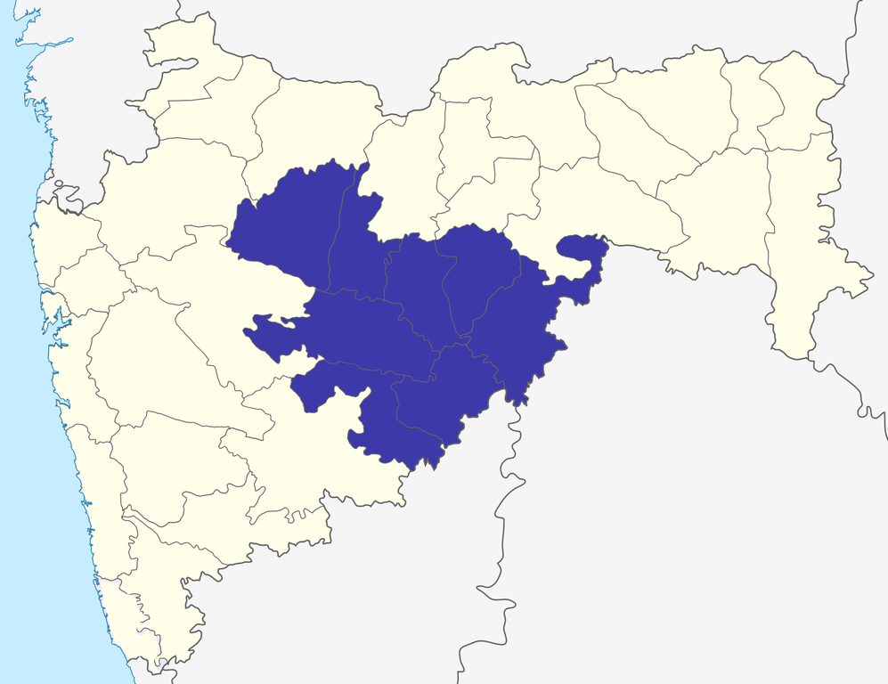
| Description | Chhatrapati Sambhajinagar division in Maharashtra, India |
| Date | (UTC) |
| Source | |
| Author |
|
| Other versions | Derivative works of this file: Nanded division.png |
| This is a
retouched picture, which means that it has been digitally altered from its original version. The original can be viewed here:
Maharashtra locator map.svg:
|
I, the copyright holder of this work, hereby publish it under the following license:
This file is licensed under the
Creative Commons
Attribution-Share Alike 3.0 Unported license.
- You are free:
- to share – to copy, distribute and transmit the work
- to remix – to adapt the work
- Under the following conditions:
- attribution – You must give appropriate credit, provide a link to the license, and indicate if changes were made. You may do so in any reasonable manner, but not in any way that suggests the licensor endorses you or your use.
- share alike – If you remix, transform, or build upon the material, you must distribute your contributions under the same or compatible license as the original.
Original upload log
This image is a derivative work of the following images:
-
File:Maharashtra_locator_map.svg licensed with Cc-by-sa-3.0
- 2008-12-21T12:11:22Z PlaneMad 2789x2232 (365545 Bytes) {{Information |Description= |Source= |Date= |Author= |Permission= |other_versions= }}
- 2008-12-21T12:08:04Z PlaneMad 2789x2232 (365091 Bytes) {{Information |Description={{en|1=map}} |Source=Own work by uploader |Author=[[User:PlaneMad|PlaneMad]] |Date= |Permission= |other_versions= }}
Uploaded with derivativeFX
File history
Click on a date/time to view the file as it appeared at that time.
| Date/Time | Thumbnail | Dimensions | User | Comment | |
|---|---|---|---|---|---|
| current | 11:41, 6 October 2015 |
| 2,168 × 1,671 (425 KB) | Abhijitsathe | Added Palghar district to state map |
| 17:52, 23 September 2009 |
 | 2,789 × 2,232 (948 KB) | Abhijitsathe | India map inset | |
| 15:14, 15 July 2009 |
 | 2,789 × 2,232 (507 KB) | Abhijitsathe | {{Information |Description=Aurangabad division in Maharashtra, India |Source=* File:Maharashtra_locator_map.svg |Date=2009-07-15 15:13 (UTC) |Author=* File:Maharashtra_locator_map.svg: '''Cc-by-sa-3.0''' *derivative work: ~~~ |Permission=see bel |
File usage
The following pages on the English Wikipedia use this file (pages on other projects are not listed):
- Adgaon Kh
- Aurangabad division
- Bhusni
- Deulgaon Bazar
- Economy of Maharashtra
- Gangapur, Maharashtra
- Hajipurwadi
- Jarul
- Jnaneshwar Udyan
- Kannad
- Kendriya Vidyalaya Aurangabad
- Koli Bodkha
- Marathwada
- Shirur Anantpal
- Shuli Bhanjan
- Valley of Saints
- User talk:Jagrutmaruti
- Wikipedia:Graphics Lab/Map workshop/Archive/Apr 2015
- Template:AurangabadMH-geo-stub
Global file usage
The following other wikis use this file:
- Usage on bn.wikipedia.org
- Usage on ca.wikipedia.org
- Usage on de.wikipedia.org
- Usage on es.wikipedia.org
- Usage on fa.wikipedia.org
- Usage on fr.wikipedia.org
- Usage on hi.wikipedia.org
- Usage on it.wikipedia.org
- Usage on mr.wikipedia.org
- Usage on pnb.wikipedia.org
- Usage on simple.wikipedia.org
- Usage on sv.wikipedia.org
- Usage on ta.wikipedia.org
- Usage on te.wikipedia.org
- Usage on ur.wikipedia.org
- Usage on www.wikidata.org
- Usage on zh.wikipedia.org
Size of this preview:
778 × 600 pixels. Other resolutions:
312 × 240 pixels |
623 × 480 pixels |
997 × 768 pixels |
1,280 × 987 pixels |
2,168 × 1,671 pixels.
Original file (2,168 × 1,671 pixels, file size: 425 KB, MIME type: image/png)
| This is a file from the
Wikimedia Commons. Information from its
description page there is shown below. Commons is a freely licensed media file repository. You can help. |
| Description | Chhatrapati Sambhajinagar division in Maharashtra, India |
| Date | (UTC) |
| Source | |
| Author |
|
| Other versions | Derivative works of this file: Nanded division.png |
| This is a
retouched picture, which means that it has been digitally altered from its original version. The original can be viewed here:
Maharashtra locator map.svg:
|
I, the copyright holder of this work, hereby publish it under the following license:
This file is licensed under the
Creative Commons
Attribution-Share Alike 3.0 Unported license.
- You are free:
- to share – to copy, distribute and transmit the work
- to remix – to adapt the work
- Under the following conditions:
- attribution – You must give appropriate credit, provide a link to the license, and indicate if changes were made. You may do so in any reasonable manner, but not in any way that suggests the licensor endorses you or your use.
- share alike – If you remix, transform, or build upon the material, you must distribute your contributions under the same or compatible license as the original.
Original upload log
This image is a derivative work of the following images:
-
File:Maharashtra_locator_map.svg licensed with Cc-by-sa-3.0
- 2008-12-21T12:11:22Z PlaneMad 2789x2232 (365545 Bytes) {{Information |Description= |Source= |Date= |Author= |Permission= |other_versions= }}
- 2008-12-21T12:08:04Z PlaneMad 2789x2232 (365091 Bytes) {{Information |Description={{en|1=map}} |Source=Own work by uploader |Author=[[User:PlaneMad|PlaneMad]] |Date= |Permission= |other_versions= }}
Uploaded with derivativeFX
File history
Click on a date/time to view the file as it appeared at that time.
| Date/Time | Thumbnail | Dimensions | User | Comment | |
|---|---|---|---|---|---|
| current | 11:41, 6 October 2015 |
| 2,168 × 1,671 (425 KB) | Abhijitsathe | Added Palghar district to state map |
| 17:52, 23 September 2009 |
| 2,789 × 2,232 (948 KB) | Abhijitsathe | India map inset | |
| 15:14, 15 July 2009 |
| 2,789 × 2,232 (507 KB) | Abhijitsathe | {{Information |Description=Aurangabad division in Maharashtra, India |Source=* File:Maharashtra_locator_map.svg |Date=2009-07-15 15:13 (UTC) |Author=* File:Maharashtra_locator_map.svg: '''Cc-by-sa-3.0''' *derivative work: ~~~ |Permission=see bel |
File usage
The following pages on the English Wikipedia use this file (pages on other projects are not listed):
- Adgaon Kh
- Aurangabad division
- Bhusni
- Deulgaon Bazar
- Economy of Maharashtra
- Gangapur, Maharashtra
- Hajipurwadi
- Jarul
- Jnaneshwar Udyan
- Kannad
- Kendriya Vidyalaya Aurangabad
- Koli Bodkha
- Marathwada
- Shirur Anantpal
- Shuli Bhanjan
- Valley of Saints
- User talk:Jagrutmaruti
- Wikipedia:Graphics Lab/Map workshop/Archive/Apr 2015
- Template:AurangabadMH-geo-stub
Global file usage
The following other wikis use this file:
- Usage on bn.wikipedia.org
- Usage on ca.wikipedia.org
- Usage on de.wikipedia.org
- Usage on es.wikipedia.org
- Usage on fa.wikipedia.org
- Usage on fr.wikipedia.org
- Usage on hi.wikipedia.org
- Usage on it.wikipedia.org
- Usage on mr.wikipedia.org
- Usage on pnb.wikipedia.org
- Usage on simple.wikipedia.org
- Usage on sv.wikipedia.org
- Usage on ta.wikipedia.org
- Usage on te.wikipedia.org
- Usage on ur.wikipedia.org
- Usage on www.wikidata.org
- Usage on zh.wikipedia.org