
Size of this preview:
297 × 599 pixels. Other resolutions:
119 × 240 pixels |
496 × 1,000 pixels.
Original file (496 × 1,000 pixels, file size: 228 KB, MIME type: image/png)
| This is a file from the
Wikimedia Commons. Information from its
description page there is shown below. Commons is a freely licensed media file repository. You can help. |
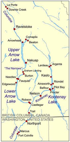
| Description | This is a map showing steamboat ports on the Arrow Lakes and Kootenay Lake, in western Canada. |
| Date | |
| Source | self-made, based on Digital Chart of the World data with Virtual Museum of Canada, BCGNIS, and Integrated Land Management Bureau used as references. |
| Author | Kmusser |
I, the copyright holder of this work, hereby publish it under the following license:
This file is licensed under the
Creative Commons
Attribution-Share Alike 3.0 Unported license.
- You are free:
- to share – to copy, distribute and transmit the work
- to remix – to adapt the work
- Under the following conditions:
- attribution – You must give appropriate credit, provide a link to the license, and indicate if changes were made. You may do so in any reasonable manner, but not in any way that suggests the licensor endorses you or your use.
- share alike – If you remix, transform, or build upon the material, you must distribute your contributions under the same or compatible license as the original.
File history
Click on a date/time to view the file as it appeared at that time.
| Date/Time | Thumbnail | Dimensions | User | Comment | |
|---|---|---|---|---|---|
| current | 19:12, 13 May 2008 |
| 496 × 1,000 (228 KB) | Kmusser | Added Comaplix |
| 17:35, 13 May 2008 |
 | 496 × 1,000 (225 KB) | Kmusser | {{Information |Description=This is a map showing steamboat ports on the Arrow Lakes and Kootenay Lakes. |Source=self-made, based on Digital Chart of the World data with [http://w |
File usage
The following pages on the English Wikipedia use this file (pages on other projects are not listed):
Global file usage
The following other wikis use this file:
- Usage on es.wikipedia.org
- Usage on www.wikidata.org
Size of this preview:
297 × 599 pixels. Other resolutions:
119 × 240 pixels |
496 × 1,000 pixels.
Original file (496 × 1,000 pixels, file size: 228 KB, MIME type: image/png)
| This is a file from the
Wikimedia Commons. Information from its
description page there is shown below. Commons is a freely licensed media file repository. You can help. |
| Description | This is a map showing steamboat ports on the Arrow Lakes and Kootenay Lake, in western Canada. |
| Date | |
| Source | self-made, based on Digital Chart of the World data with Virtual Museum of Canada, BCGNIS, and Integrated Land Management Bureau used as references. |
| Author | Kmusser |
I, the copyright holder of this work, hereby publish it under the following license:
This file is licensed under the
Creative Commons
Attribution-Share Alike 3.0 Unported license.
- You are free:
- to share – to copy, distribute and transmit the work
- to remix – to adapt the work
- Under the following conditions:
- attribution – You must give appropriate credit, provide a link to the license, and indicate if changes were made. You may do so in any reasonable manner, but not in any way that suggests the licensor endorses you or your use.
- share alike – If you remix, transform, or build upon the material, you must distribute your contributions under the same or compatible license as the original.
File history
Click on a date/time to view the file as it appeared at that time.
| Date/Time | Thumbnail | Dimensions | User | Comment | |
|---|---|---|---|---|---|
| current | 19:12, 13 May 2008 |
| 496 × 1,000 (228 KB) | Kmusser | Added Comaplix |
| 17:35, 13 May 2008 |
| 496 × 1,000 (225 KB) | Kmusser | {{Information |Description=This is a map showing steamboat ports on the Arrow Lakes and Kootenay Lakes. |Source=self-made, based on Digital Chart of the World data with [http://w |
File usage
The following pages on the English Wikipedia use this file (pages on other projects are not listed):
Global file usage
The following other wikis use this file:
- Usage on es.wikipedia.org
- Usage on www.wikidata.org