Size of this preview:
800 × 481 pixels. Other resolutions:
320 × 192 pixels |
640 × 385 pixels |
1,024 × 616 pixels |
1,636 × 984 pixels.
Original file (1,636 × 984 pixels, file size: 82 KB, MIME type: image/png)
| This is a file from the
Wikimedia Commons. Information from its
description page there is shown below. Commons is a freely licensed media file repository. You can help. |
Summary
| Description |
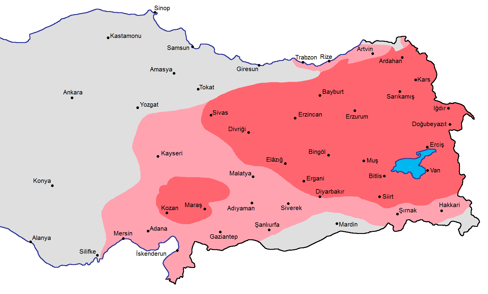
English: A map showing the distribution of the
Armenians in early 17th century with the current borders of Turkey: red (majority), pink (significant presence) source: State Committee of the Real Estate Cadastre of the Republic of Armenia (2007). Հայաստանի Ազգային Ատլաս (National Atlas of Armenia), Yerevan: Center of Geodesy and Cartography SNPO, p. 102 see map |
| Date | |
| Source | Own work |
| Author | Yerevanci |
Licensing
I, the copyright holder of this work, hereby publish it under the following license:
This file is licensed under the
Creative Commons
Attribution-Share Alike 3.0 Unported license.
- You are free:
- to share – to copy, distribute and transmit the work
- to remix – to adapt the work
- Under the following conditions:
- attribution – You must give appropriate credit, provide a link to the license, and indicate if changes were made. You may do so in any reasonable manner, but not in any way that suggests the licensor endorses you or your use.
- share alike – If you remix, transform, or build upon the material, you must distribute your contributions under the same or compatible license as the original.
File history
Click on a date/time to view the file as it appeared at that time.
| Date/Time | Thumbnail | Dimensions | User | Comment | |
|---|---|---|---|---|---|
| current | 06:51, 3 September 2013 |
| 1,636 × 984 (82 KB) | Yerevanci | minor fix |
| 20:57, 28 August 2013 |
 | 1,636 × 984 (82 KB) | Yerevanci | User created page with UploadWizard |
File usage
The following pages on the English Wikipedia use this file (pages on other projects are not listed):
Global file usage
The following other wikis use this file:
- Usage on ar.wikipedia.org
- Usage on bg.wikipedia.org
- Usage on bn.wikipedia.org
- Usage on ca.wikipedia.org
- Usage on diq.wikipedia.org
- Usage on el.wikipedia.org
- Usage on eo.wikipedia.org
- Usage on es.wikipedia.org
- Usage on fa.wikipedia.org
- Usage on fi.wikipedia.org
- Usage on hy.wikipedia.org
- Usage on hyw.wikipedia.org
- Usage on id.wikipedia.org
- Usage on it.wikipedia.org
- Usage on no.wikipedia.org
- Usage on ru.wikipedia.org
- Usage on sr.wikipedia.org
- Usage on zh.wikipedia.org
Metadata
Size of this preview:
800 × 481 pixels. Other resolutions:
320 × 192 pixels |
640 × 385 pixels |
1,024 × 616 pixels |
1,636 × 984 pixels.
Original file (1,636 × 984 pixels, file size: 82 KB, MIME type: image/png)
| This is a file from the
Wikimedia Commons. Information from its
description page there is shown below. Commons is a freely licensed media file repository. You can help. |
Summary
| Description |
English: A map showing the distribution of the
Armenians in early 17th century with the current borders of Turkey: red (majority), pink (significant presence) source: State Committee of the Real Estate Cadastre of the Republic of Armenia (2007). Հայաստանի Ազգային Ատլաս (National Atlas of Armenia), Yerevan: Center of Geodesy and Cartography SNPO, p. 102 see map |
| Date | |
| Source | Own work |
| Author | Yerevanci |
Licensing
I, the copyright holder of this work, hereby publish it under the following license:
This file is licensed under the
Creative Commons
Attribution-Share Alike 3.0 Unported license.
- You are free:
- to share – to copy, distribute and transmit the work
- to remix – to adapt the work
- Under the following conditions:
- attribution – You must give appropriate credit, provide a link to the license, and indicate if changes were made. You may do so in any reasonable manner, but not in any way that suggests the licensor endorses you or your use.
- share alike – If you remix, transform, or build upon the material, you must distribute your contributions under the same or compatible license as the original.
File history
Click on a date/time to view the file as it appeared at that time.
| Date/Time | Thumbnail | Dimensions | User | Comment | |
|---|---|---|---|---|---|
| current | 06:51, 3 September 2013 |
| 1,636 × 984 (82 KB) | Yerevanci | minor fix |
| 20:57, 28 August 2013 |
| 1,636 × 984 (82 KB) | Yerevanci | User created page with UploadWizard |
File usage
The following pages on the English Wikipedia use this file (pages on other projects are not listed):
Global file usage
The following other wikis use this file:
- Usage on ar.wikipedia.org
- Usage on bg.wikipedia.org
- Usage on bn.wikipedia.org
- Usage on ca.wikipedia.org
- Usage on diq.wikipedia.org
- Usage on el.wikipedia.org
- Usage on eo.wikipedia.org
- Usage on es.wikipedia.org
- Usage on fa.wikipedia.org
- Usage on fi.wikipedia.org
- Usage on hy.wikipedia.org
- Usage on hyw.wikipedia.org
- Usage on id.wikipedia.org
- Usage on it.wikipedia.org
- Usage on no.wikipedia.org
- Usage on ru.wikipedia.org
- Usage on sr.wikipedia.org
- Usage on zh.wikipedia.org