Size of this preview:
157 × 600 pixels. Other resolution:
259 × 989 pixels.
Original file (259 × 989 pixels, file size: 251 KB, MIME type: image/png)
| This is a file from the
Wikimedia Commons. Information from its
description page there is shown below. Commons is a freely licensed media file repository. You can help. |
Summary
| Description |
Català: Les diferents cultures establertes a l'Àrtic entre els anys 900 i 1500. Cultures de l'Àrtic entre els anys 900 i 1500.
Dansk: Grønland omkring 1500. [redigér] Kulturer i forhistorisk tid. Kortene viser de forskellige kulturers tilstedeværelse i Grønland, Labrador, Newfoundland og de Canadiske arktiske øer i årene 900, 1100, 1300 og 1500. Norse=Nordboer. Historiske kulturer i arktiske Nord-Amerika.
Deutsch: Besiedlung Grönlands: Dunkelrot sind die Nordmänner, alle anderen sind Skrælingar. Besiedlung Grönlands von 900 bis 1500.
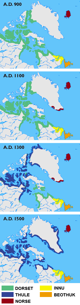
English: Maps showing the different cultures in Greenland, Labrador, Newfoundland and the Canadian arctic islands in the years 900, 1100, 1300 and 1500. The green colour shows the Dorset Culture, blue the Thule Culture, red Norse Culture, yellow Innu and orange Beothuk.
Español: Culturas árticas. Mapas mostrando las diferentes culturas en Groenlandia, Labrador, Newfoundland y el Ártico canadiense en los años 900, 1100, 1300 y 1500. El color verde muestra la Cultura Dorset, el azul la Cultura Thule, en rojo Cultura Nórdica, en amarillo Innu y naranja Beothuk. Distribución cultural cercana a Groenlandia a través del tiempo.
Suomi: Thulen kulttuuri korvasi aiemman Dorsetin kulttuurin Pohjois-Amerikan seudun arktisilla alueilla.
Français : Histoire des cultures articques (900-1500). Expansion territoriale de différentes cultures dans l'Arctique.
Íslenska: Fólksfluttningar á árunum 900 til 1500. Græni liturinn sýnir Dorset-fólk, blái Thule-inuíta, rauði norræna menn, guli Innu-indjána og appelsínugule Beothuk-indjána.
Italiano: La mappa mostra le differenti civiltà che vissero in Groenlandia, Labrador, Newfoundland e nelle isole artiche del Canada negli anni 900, 1100, 1300 e 1500. Verde:Civiltà Dorset, blu: Civiltà Thule, rosso:Civiltà nordica, Giallo: Innu e arancione: Beothuk.
日本語: 900年、1100年、1300年、1500年時点での、アイスランド、グリーンランド、ラブラドル半島、ニューファンドランド島、その他カナダの北極圏の島における民族の移り変わりの推定図。緑色がドーセット文化、青がトゥーレ文化、赤がノース人、黄色がイヌ族、オレンジがベオスック族. 緑:ドーセット (Dorset culture) 、黄:インヌ (Innu) 、青:トゥーレ、橙:ベオサック (Beothuk) 、茶:ノース.
Lietuvių: Arkties kultūrų kaita.
Македонски: Карта на различните култури на Гренланд, Лабрадор, Њуфаундленд и канадските поларни острови во 900, 1100, 1300 и 1500 г.; зелено: дорсетска култура, сино: тулска култура, црвено: нордиска култура, жолто: Ину, портокалово: Беотуци.
Nederlands: Bewoning Groenland: Donkerrood zijn de "Noormannen" , alle anderen zijn Skrælingar.
Norsk bokmål: Historiske kulturer i arktiske Nord-Amerika.
Русский: Карта культур северной Канады и Гренландии (900—1500 гг.).
Svenska: Nordbor och skrälingar 900-1500. Grönt = Dorsetkulturen. Blått = Thulekulturen. Rött = Nordmän. Gult = Innu. Orange = Beothuk.
Türkçe: Kutup bölgesi yerel halklarının dönemlere göre yaşadıkları yerler; ESKİMO (Dorset ve Thule), KIZILDERİLİ (Innu ve Beothuk), İSKANDİNAV (Norse). Arktika kültürleri.
Українська: Культури Гренландії й північної Канади у 900 - 1500 роках н.е.
中文:公元(A.D.)900年至1500年间北极地区各种文化消长对比,绿色的是多尔塞特文化,而蓝色的是图尔文化。. |
||
| Date | |||
| Source |
Own work based on: Grønlands forhistorie, editor. Hans Christian Gulløv, Gyldendal 2005, ISBN 87-02-01724-5 National Museum of Natural History, Arctic Studies Center [1] |
||
| Author | Masae | ||
| Other versions |

.png)
.png)
Licensing
I, the copyright holder of this work, hereby publish it under the following licenses:

|
Permission is granted to copy, distribute and/or modify this document under the terms of the GNU Free Documentation License, Version 1.2 or any later version published by the Free Software Foundation; with no Invariant Sections, no Front-Cover Texts, and no Back-Cover Texts. A copy of the license is included in the section entitled GNU Free Documentation License. |
| This file is licensed under the Creative Commons Attribution-Share Alike 3.0 Unported license. | ||
| ||
| This licensing tag was added to this file as part of the GFDL licensing update. |
This file is licensed under the
Creative Commons Attribution-Share Alike
2.5 Generic,
2.0 Generic and
1.0 Generic license.
- You are free:
- to share – to copy, distribute and transmit the work
- to remix – to adapt the work
- Under the following conditions:
- attribution – You must give appropriate credit, provide a link to the license, and indicate if changes were made. You may do so in any reasonable manner, but not in any way that suggests the licensor endorses you or your use.
- share alike – If you remix, transform, or build upon the material, you must distribute your contributions under the same or compatible license as the original.
You may select the license of your choice.
File history
Click on a date/time to view the file as it appeared at that time.
| Date/Time | Thumbnail | Dimensions | User | Comment | |
|---|---|---|---|---|---|
| current | 14:46, 20 September 2010 |
| 259 × 989 (251 KB) | Kmusser | a touch of smoothing |
| 14:33, 20 September 2010 |
| 259 × 989 (209 KB) | Gringer | more colourblind-friendly | |
| 16:59, 6 June 2010 |
| 259 × 989 (228 KB) | Beao | Tweak. | |
| 07:46, 6 December 2006 |
| 259 × 989 (205 KB) | Masae~commonswiki | == Summary == {{Information |Description=Maps showing the different cultures in Greenland, Labrador, Newfoundland and the Canadian artic islands in the years 900, 1100, 1300 and 1500. The green colour shows the Dorset Culture, blue the Thule Culture, red | |
| 15:56, 29 November 2006 |
| 259 × 989 (205 KB) | Masae~commonswiki | {{Information |Description=Maps showing the different cultures in Greenland, Labrador, Newfoundland and the Canadian artic islands. |Source=Own work |Date=29 November 2006 |Author=Masae |Permission= |other_versions= }} |
File usage
The following pages on the English Wikipedia use this file (pages on other projects are not listed):
Global file usage
The following other wikis use this file:
- Usage on ar.wikipedia.org
- Usage on ba.wikipedia.org
- Usage on be.wikipedia.org
- Usage on bg.wikipedia.org
- Usage on ca.wikipedia.org
- Usage on da.wikipedia.org
- Usage on da.wikibooks.org
- Usage on de.wikipedia.org
- Usage on en.wikivoyage.org
- Usage on es.wikipedia.org
- Usage on et.wikipedia.org
- Usage on eu.wikipedia.org
- Usage on fa.wikipedia.org
- Usage on fi.wikipedia.org
- Usage on fr.wikipedia.org
- Usage on gl.wikipedia.org
- Usage on hu.wikipedia.org
- Usage on hy.wikipedia.org
- Usage on id.wikipedia.org
- Usage on io.wikipedia.org
- Usage on is.wikipedia.org
- Usage on it.wikipedia.org
- Usage on ja.wikipedia.org
- Usage on ko.wikipedia.org
View more global usage of this file.
Metadata
Size of this preview:
157 × 600 pixels. Other resolution:
259 × 989 pixels.
Original file (259 × 989 pixels, file size: 251 KB, MIME type: image/png)
| This is a file from the
Wikimedia Commons. Information from its
description page there is shown below. Commons is a freely licensed media file repository. You can help. |
Summary
| Description |
Català: Les diferents cultures establertes a l'Àrtic entre els anys 900 i 1500. Cultures de l'Àrtic entre els anys 900 i 1500.
Dansk: Grønland omkring 1500. [redigér] Kulturer i forhistorisk tid. Kortene viser de forskellige kulturers tilstedeværelse i Grønland, Labrador, Newfoundland og de Canadiske arktiske øer i årene 900, 1100, 1300 og 1500. Norse=Nordboer. Historiske kulturer i arktiske Nord-Amerika.
Deutsch: Besiedlung Grönlands: Dunkelrot sind die Nordmänner, alle anderen sind Skrælingar. Besiedlung Grönlands von 900 bis 1500.
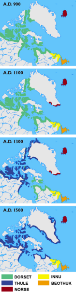
English: Maps showing the different cultures in Greenland, Labrador, Newfoundland and the Canadian arctic islands in the years 900, 1100, 1300 and 1500. The green colour shows the Dorset Culture, blue the Thule Culture, red Norse Culture, yellow Innu and orange Beothuk.
Español: Culturas árticas. Mapas mostrando las diferentes culturas en Groenlandia, Labrador, Newfoundland y el Ártico canadiense en los años 900, 1100, 1300 y 1500. El color verde muestra la Cultura Dorset, el azul la Cultura Thule, en rojo Cultura Nórdica, en amarillo Innu y naranja Beothuk. Distribución cultural cercana a Groenlandia a través del tiempo.
Suomi: Thulen kulttuuri korvasi aiemman Dorsetin kulttuurin Pohjois-Amerikan seudun arktisilla alueilla.
Français : Histoire des cultures articques (900-1500). Expansion territoriale de différentes cultures dans l'Arctique.
Íslenska: Fólksfluttningar á árunum 900 til 1500. Græni liturinn sýnir Dorset-fólk, blái Thule-inuíta, rauði norræna menn, guli Innu-indjána og appelsínugule Beothuk-indjána.
Italiano: La mappa mostra le differenti civiltà che vissero in Groenlandia, Labrador, Newfoundland e nelle isole artiche del Canada negli anni 900, 1100, 1300 e 1500. Verde:Civiltà Dorset, blu: Civiltà Thule, rosso:Civiltà nordica, Giallo: Innu e arancione: Beothuk.
日本語: 900年、1100年、1300年、1500年時点での、アイスランド、グリーンランド、ラブラドル半島、ニューファンドランド島、その他カナダの北極圏の島における民族の移り変わりの推定図。緑色がドーセット文化、青がトゥーレ文化、赤がノース人、黄色がイヌ族、オレンジがベオスック族. 緑:ドーセット (Dorset culture) 、黄:インヌ (Innu) 、青:トゥーレ、橙:ベオサック (Beothuk) 、茶:ノース.
Lietuvių: Arkties kultūrų kaita.
Македонски: Карта на различните култури на Гренланд, Лабрадор, Њуфаундленд и канадските поларни острови во 900, 1100, 1300 и 1500 г.; зелено: дорсетска култура, сино: тулска култура, црвено: нордиска култура, жолто: Ину, портокалово: Беотуци.
Nederlands: Bewoning Groenland: Donkerrood zijn de "Noormannen" , alle anderen zijn Skrælingar.
Norsk bokmål: Historiske kulturer i arktiske Nord-Amerika.
Русский: Карта культур северной Канады и Гренландии (900—1500 гг.).
Svenska: Nordbor och skrälingar 900-1500. Grönt = Dorsetkulturen. Blått = Thulekulturen. Rött = Nordmän. Gult = Innu. Orange = Beothuk.
Türkçe: Kutup bölgesi yerel halklarının dönemlere göre yaşadıkları yerler; ESKİMO (Dorset ve Thule), KIZILDERİLİ (Innu ve Beothuk), İSKANDİNAV (Norse). Arktika kültürleri.
Українська: Культури Гренландії й північної Канади у 900 - 1500 роках н.е.
中文:公元(A.D.)900年至1500年间北极地区各种文化消长对比,绿色的是多尔塞特文化,而蓝色的是图尔文化。. |
||
| Date | |||
| Source |
Own work based on: Grønlands forhistorie, editor. Hans Christian Gulløv, Gyldendal 2005, ISBN 87-02-01724-5 National Museum of Natural History, Arctic Studies Center [1] |
||
| Author | Masae | ||
| Other versions |
Licensing
I, the copyright holder of this work, hereby publish it under the following licenses:
|
|
Permission is granted to copy, distribute and/or modify this document under the terms of the GNU Free Documentation License, Version 1.2 or any later version published by the Free Software Foundation; with no Invariant Sections, no Front-Cover Texts, and no Back-Cover Texts. A copy of the license is included in the section entitled GNU Free Documentation License. |
| This file is licensed under the Creative Commons Attribution-Share Alike 3.0 Unported license. | ||
| ||
| This licensing tag was added to this file as part of the GFDL licensing update. |
This file is licensed under the
Creative Commons Attribution-Share Alike
2.5 Generic,
2.0 Generic and
1.0 Generic license.
- You are free:
- to share – to copy, distribute and transmit the work
- to remix – to adapt the work
- Under the following conditions:
- attribution – You must give appropriate credit, provide a link to the license, and indicate if changes were made. You may do so in any reasonable manner, but not in any way that suggests the licensor endorses you or your use.
- share alike – If you remix, transform, or build upon the material, you must distribute your contributions under the same or compatible license as the original.
You may select the license of your choice.
File history
Click on a date/time to view the file as it appeared at that time.
| Date/Time | Thumbnail | Dimensions | User | Comment | |
|---|---|---|---|---|---|
| current | 14:46, 20 September 2010 |
| 259 × 989 (251 KB) | Kmusser | a touch of smoothing |
| 14:33, 20 September 2010 |
| 259 × 989 (209 KB) | Gringer | more colourblind-friendly | |
| 16:59, 6 June 2010 |
| 259 × 989 (228 KB) | Beao | Tweak. | |
| 07:46, 6 December 2006 |
| 259 × 989 (205 KB) | Masae~commonswiki | == Summary == {{Information |Description=Maps showing the different cultures in Greenland, Labrador, Newfoundland and the Canadian artic islands in the years 900, 1100, 1300 and 1500. The green colour shows the Dorset Culture, blue the Thule Culture, red | |
| 15:56, 29 November 2006 |
| 259 × 989 (205 KB) | Masae~commonswiki | {{Information |Description=Maps showing the different cultures in Greenland, Labrador, Newfoundland and the Canadian artic islands. |Source=Own work |Date=29 November 2006 |Author=Masae |Permission= |other_versions= }} |
File usage
The following pages on the English Wikipedia use this file (pages on other projects are not listed):
Global file usage
The following other wikis use this file:
- Usage on ar.wikipedia.org
- Usage on ba.wikipedia.org
- Usage on be.wikipedia.org
- Usage on bg.wikipedia.org
- Usage on ca.wikipedia.org
- Usage on da.wikipedia.org
- Usage on da.wikibooks.org
- Usage on de.wikipedia.org
- Usage on en.wikivoyage.org
- Usage on es.wikipedia.org
- Usage on et.wikipedia.org
- Usage on eu.wikipedia.org
- Usage on fa.wikipedia.org
- Usage on fi.wikipedia.org
- Usage on fr.wikipedia.org
- Usage on gl.wikipedia.org
- Usage on hu.wikipedia.org
- Usage on hy.wikipedia.org
- Usage on id.wikipedia.org
- Usage on io.wikipedia.org
- Usage on is.wikipedia.org
- Usage on it.wikipedia.org
- Usage on ja.wikipedia.org
- Usage on ko.wikipedia.org
View more global usage of this file.