Size of this preview:
732 × 600 pixels. Other resolutions:
293 × 240 pixels |
586 × 480 pixels |
937 × 768 pixels |
1,250 × 1,024 pixels |
2,499 × 2,048 pixels |
3,500 × 2,868 pixels.
Original file (3,500 × 2,868 pixels, file size: 3.72 MB, MIME type: image/png)
| This is a file from the
Wikimedia Commons. Information from its
description page there is shown below. Commons is a freely licensed media file repository. You can help. |
| Description |
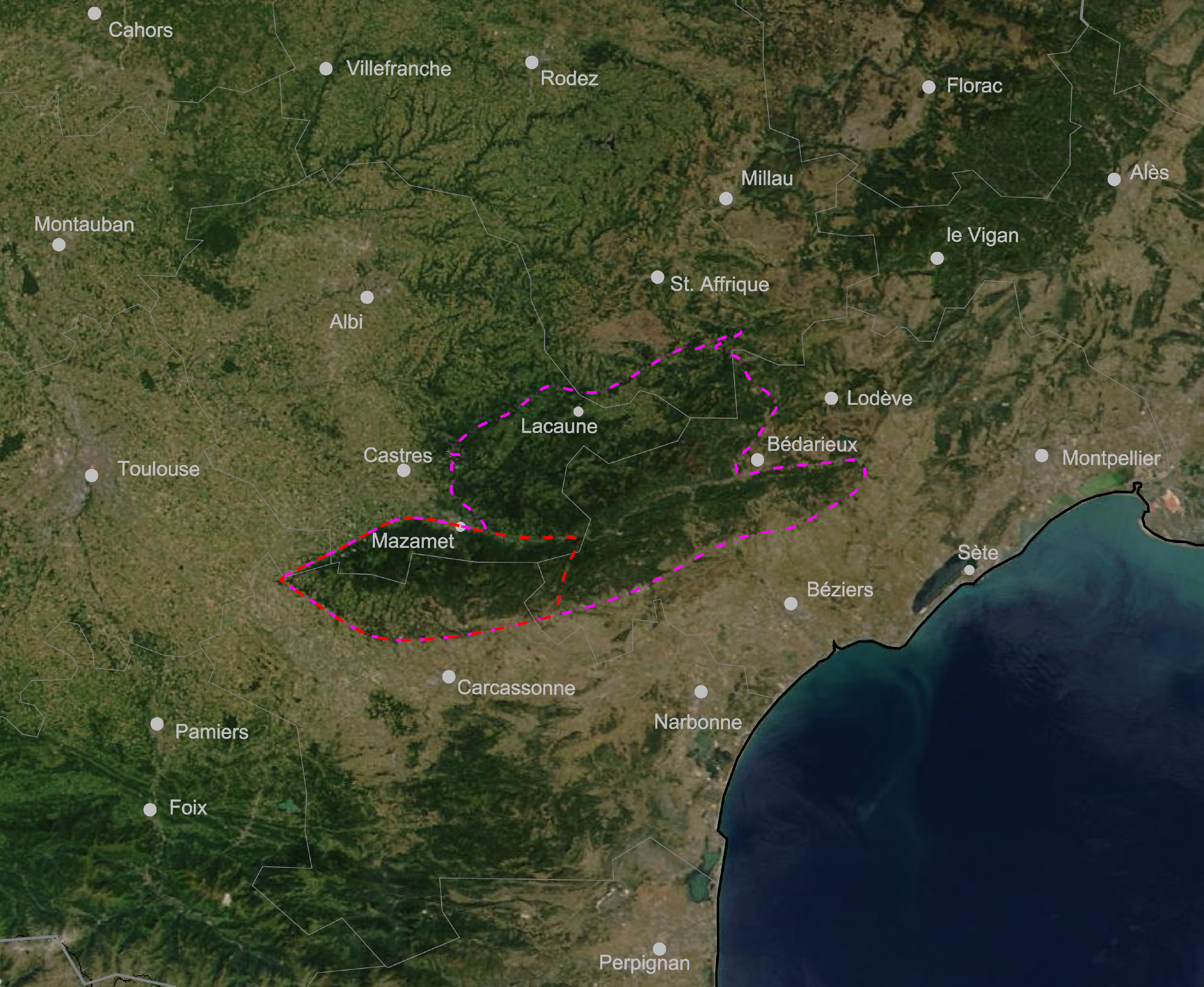
English: Outline of the
Montagne Noire. Geographic extent in red, geologic extent in magenta. Departements in grey Deutsch: Umriss der
Montagne Noire. Geographische Ausdehnung in rot, geologische Ausdehnung in magenta. Departementgrenzen in grau Français : La
Montagne Noire en photo satéllite. Étendue géographique en rouge, étendue géologique en magenta. Limites des département en gris |
| Date | |
| Source | Drawn on Satellite image of France in August 2002.jpg |
| Author | Jo Weber |
| This file is in the public domain in the United States because it was solely created by NASA. NASA copyright policy states that "NASA material is not protected by copyright unless noted". (See Template:PD-USGov, NASA copyright policy page or JPL Image Use Policy.) | ||
 |
Warnings:
|
| |
This work has been released into the
public domain by its author,
Jo Weber, at the
English Wikipedia project. This applies worldwide. In case this is not legally possible: |
File history
Click on a date/time to view the file as it appeared at that time.
| Date/Time | Thumbnail | Dimensions | User | Comment | |
|---|---|---|---|---|---|
| current | 19:42, 2 May 2008 |
| 3,500 × 2,868 (3.72 MB) | Jo Weber | Correction of geographical extent |
| 18:26, 2 May 2008 |
 | 3,762 × 3,083 (5.38 MB) | Jo Weber | ||
| 18:23, 2 May 2008 |
 | 4,180 × 3,425 (4.3 MB) | Jo Weber | {{Information |Description={{en|Outline of the '' Montagne Noire}}{{de|Umriss der '' Montagne Noire}}{{fr|La '' Montagne Noire en photo satéllite}} |Source=Drawn on [[:Image:Satellite_ima |
File usage
The following pages on the English Wikipedia use this file (pages on other projects are not listed):
Global file usage
The following other wikis use this file:
- Usage on ca.wikipedia.org
- Usage on de.wikipedia.org
- Usage on eo.wikipedia.org
- Usage on fr.wikipedia.org
- Usage on nl.wikipedia.org
- Usage on oc.wikipedia.org
Size of this preview:
732 × 600 pixels. Other resolutions:
293 × 240 pixels |
586 × 480 pixels |
937 × 768 pixels |
1,250 × 1,024 pixels |
2,499 × 2,048 pixels |
3,500 × 2,868 pixels.
Original file (3,500 × 2,868 pixels, file size: 3.72 MB, MIME type: image/png)
| This is a file from the
Wikimedia Commons. Information from its
description page there is shown below. Commons is a freely licensed media file repository. You can help. |
| Description |
English: Outline of the
Montagne Noire. Geographic extent in red, geologic extent in magenta. Departements in grey Deutsch: Umriss der
Montagne Noire. Geographische Ausdehnung in rot, geologische Ausdehnung in magenta. Departementgrenzen in grau Français : La
Montagne Noire en photo satéllite. Étendue géographique en rouge, étendue géologique en magenta. Limites des département en gris |
| Date | |
| Source | Drawn on Satellite image of France in August 2002.jpg |
| Author | Jo Weber |
| This file is in the public domain in the United States because it was solely created by NASA. NASA copyright policy states that "NASA material is not protected by copyright unless noted". (See Template:PD-USGov, NASA copyright policy page or JPL Image Use Policy.) | ||
|
Warnings:
|
| |
This work has been released into the
public domain by its author,
Jo Weber, at the
English Wikipedia project. This applies worldwide. In case this is not legally possible: |
File history
Click on a date/time to view the file as it appeared at that time.
| Date/Time | Thumbnail | Dimensions | User | Comment | |
|---|---|---|---|---|---|
| current | 19:42, 2 May 2008 |
| 3,500 × 2,868 (3.72 MB) | Jo Weber | Correction of geographical extent |
| 18:26, 2 May 2008 |
| 3,762 × 3,083 (5.38 MB) | Jo Weber | ||
| 18:23, 2 May 2008 |
| 4,180 × 3,425 (4.3 MB) | Jo Weber | {{Information |Description={{en|Outline of the '' Montagne Noire}}{{de|Umriss der '' Montagne Noire}}{{fr|La '' Montagne Noire en photo satéllite}} |Source=Drawn on [[:Image:Satellite_ima |
File usage
The following pages on the English Wikipedia use this file (pages on other projects are not listed):
Global file usage
The following other wikis use this file:
- Usage on ca.wikipedia.org
- Usage on de.wikipedia.org
- Usage on eo.wikipedia.org
- Usage on fr.wikipedia.org
- Usage on nl.wikipedia.org
- Usage on oc.wikipedia.org