No higher resolution available.
AnatoliaAncientRegions.png (800 × 518 pixels, file size: 75 KB, MIME type: image/png)
| This is a file from the
Wikimedia Commons. Information from its
description page there is shown below. Commons is a freely licensed media file repository. You can help. |
Summary
| Description |
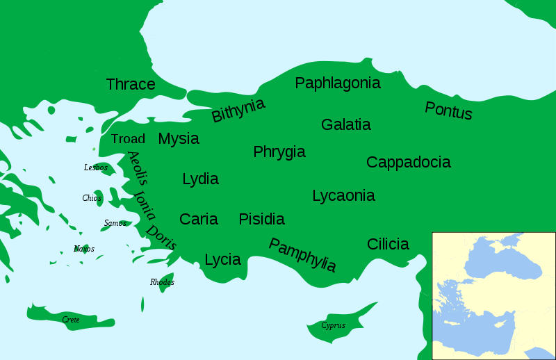
English: Political map of Asia Minor in 500 BC
Nederlands: Politieke kaart van klein Azië in 500 AD |
| Date | |
| Source | Asia_Minor_Political_500BC.svg |
| Author | Labberté K.J. |
| Permission ( Reusing this file) |
Derivative works of this file: File:Anatolia Ancient Regions base.svg |
| Other versions |
Derivative works of this file: Political map of Asia Minor in 500 BC in Masry.PNG
|


.svg)


| This is a
retouched picture, which means that it has been digitally altered from its original version. Modifications: Increased legibility, slight corrections. The original can be viewed here:
Asia Minor Political 500BC.svg:
|
Licensing
I, the copyright holder of this work, hereby publish it under the following licenses:
This file is licensed under the
Creative Commons
Attribution-Share Alike 3.0 Unported license.
- You are free:
- to share – to copy, distribute and transmit the work
- to remix – to adapt the work
- Under the following conditions:
- attribution – You must give appropriate credit, provide a link to the license, and indicate if changes were made. You may do so in any reasonable manner, but not in any way that suggests the licensor endorses you or your use.
- share alike – If you remix, transform, or build upon the material, you must distribute your contributions under the same or compatible license as the original.

|
Permission is granted to copy, distribute and/or modify this document under the terms of the GNU Free Documentation License, Version 1.2 or any later version published by the Free Software Foundation; with no Invariant Sections, no Front-Cover Texts, and no Back-Cover Texts. A copy of the license is included in the section entitled GNU Free Documentation License. |
You may select the license of your choice.
File history
Click on a date/time to view the file as it appeared at that time.
| Date/Time | Thumbnail | Dimensions | User | Comment | |
|---|---|---|---|---|---|
| current | 17:03, 3 December 2009 |
| 800 × 518 (75 KB) | Labberté K.J. | {{Information |Description={{en|1=Political map of Asia Minor in 500 BC}} {{nl|1=Politieke kaart van klein Azië in 500 AD}} |Source= Asia_Minor_Political_500BC.svg |Author= Labberté K.J. |Date=2009-12-03 |Permission=Derivative wo |
File usage
The following pages on the English Wikipedia use this file (pages on other projects are not listed):
Global file usage
The following other wikis use this file:
- Usage on fr.wikipedia.org
- Usage on ko.wikipedia.org
- Usage on nl.wikipedia.org
No higher resolution available.
AnatoliaAncientRegions.png (800 × 518 pixels, file size: 75 KB, MIME type: image/png)
| This is a file from the
Wikimedia Commons. Information from its
description page there is shown below. Commons is a freely licensed media file repository. You can help. |
Summary
| Description |
English: Political map of Asia Minor in 500 BC
Nederlands: Politieke kaart van klein Azië in 500 AD |
| Date | |
| Source | Asia_Minor_Political_500BC.svg |
| Author | Labberté K.J. |
| Permission ( Reusing this file) |
Derivative works of this file: File:Anatolia Ancient Regions base.svg |
| Other versions |
Derivative works of this file: Political map of Asia Minor in 500 BC in Masry.PNG
|
| This is a
retouched picture, which means that it has been digitally altered from its original version. Modifications: Increased legibility, slight corrections. The original can be viewed here:
Asia Minor Political 500BC.svg:
|
Licensing
I, the copyright holder of this work, hereby publish it under the following licenses:
This file is licensed under the
Creative Commons
Attribution-Share Alike 3.0 Unported license.
- You are free:
- to share – to copy, distribute and transmit the work
- to remix – to adapt the work
- Under the following conditions:
- attribution – You must give appropriate credit, provide a link to the license, and indicate if changes were made. You may do so in any reasonable manner, but not in any way that suggests the licensor endorses you or your use.
- share alike – If you remix, transform, or build upon the material, you must distribute your contributions under the same or compatible license as the original.
|
|
Permission is granted to copy, distribute and/or modify this document under the terms of the GNU Free Documentation License, Version 1.2 or any later version published by the Free Software Foundation; with no Invariant Sections, no Front-Cover Texts, and no Back-Cover Texts. A copy of the license is included in the section entitled GNU Free Documentation License. |
You may select the license of your choice.
File history
Click on a date/time to view the file as it appeared at that time.
| Date/Time | Thumbnail | Dimensions | User | Comment | |
|---|---|---|---|---|---|
| current | 17:03, 3 December 2009 |
| 800 × 518 (75 KB) | Labberté K.J. | {{Information |Description={{en|1=Political map of Asia Minor in 500 BC}} {{nl|1=Politieke kaart van klein Azië in 500 AD}} |Source= Asia_Minor_Political_500BC.svg |Author= Labberté K.J. |Date=2009-12-03 |Permission=Derivative wo |
File usage
The following pages on the English Wikipedia use this file (pages on other projects are not listed):
Global file usage
The following other wikis use this file:
- Usage on fr.wikipedia.org
- Usage on ko.wikipedia.org
- Usage on nl.wikipedia.org