
Original file (4,128 × 3,096 pixels, file size: 8.19 MB, MIME type: image/jpeg)
| This is a file from the
Wikimedia Commons. Information from its
description page there is shown below. Commons is a freely licensed media file repository. You can help. |
Summary
| Description |
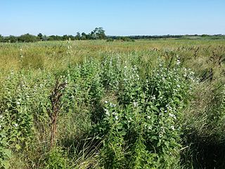
Deutsch: Habitat
Taxonym: Althaea officinalis ss Fischer et al. EfÖLS 2008
ISBN
978-3-85474-187-9 English: Habitat Taxonym: Althaea officinalis ss Fischer et al. EfÖLS 2008
ISBN
978-3-85474-187-9 |
| Date | |
| Source | Own work |
| Author | Stefan.lefnaer |
| Camera location |
| View this and other nearby images on: OpenStreetMap |
|
|---|
Licensing
- You are free:
- to share – to copy, distribute and transmit the work
- to remix – to adapt the work
- Under the following conditions:
- attribution – You must give appropriate credit, provide a link to the license, and indicate if changes were made. You may do so in any reasonable manner, but not in any way that suggests the licensor endorses you or your use.
- share alike – If you remix, transform, or build upon the material, you must distribute your contributions under the same or compatible license as the original.
File history
Click on a date/time to view the file as it appeared at that time.
| Date/Time | Thumbnail | Dimensions | User | Comment | |
|---|---|---|---|---|---|
| current | 18:18, 5 August 2016 |
| 4,128 × 3,096 (8.19 MB) | Stefan.lefnaer | User created page with UploadWizard |
File usage
Metadata
Original file (4,128 × 3,096 pixels, file size: 8.19 MB, MIME type: image/jpeg)
| This is a file from the
Wikimedia Commons. Information from its
description page there is shown below. Commons is a freely licensed media file repository. You can help. |
Summary
| Description |
Deutsch: Habitat
Taxonym: Althaea officinalis ss Fischer et al. EfÖLS 2008
ISBN
978-3-85474-187-9 English: Habitat Taxonym: Althaea officinalis ss Fischer et al. EfÖLS 2008
ISBN
978-3-85474-187-9 |
| Date | |
| Source | Own work |
| Author | Stefan.lefnaer |
| Camera location |
| View this and other nearby images on: OpenStreetMap |
|
|---|
Licensing
- You are free:
- to share – to copy, distribute and transmit the work
- to remix – to adapt the work
- Under the following conditions:
- attribution – You must give appropriate credit, provide a link to the license, and indicate if changes were made. You may do so in any reasonable manner, but not in any way that suggests the licensor endorses you or your use.
- share alike – If you remix, transform, or build upon the material, you must distribute your contributions under the same or compatible license as the original.
File history
Click on a date/time to view the file as it appeared at that time.
| Date/Time | Thumbnail | Dimensions | User | Comment | |
|---|---|---|---|---|---|
| current | 18:18, 5 August 2016 |
| 4,128 × 3,096 (8.19 MB) | Stefan.lefnaer | User created page with UploadWizard |