Photos • Location


Size of this preview:
800 × 576 pixels. Other resolutions:
320 × 230 pixels |
640 × 461 pixels |
1,024 × 737 pixels |
1,280 × 922 pixels |
2,560 × 1,843 pixels |
8,000 × 5,760 pixels.
Original file (8,000 × 5,760 pixels, file size: 37.8 MB, MIME type: image/jpeg)
| This is a file from the
Wikimedia Commons. Information from its
description page there is shown below. Commons is a freely licensed media file repository. You can help. |
Summary
| Description |
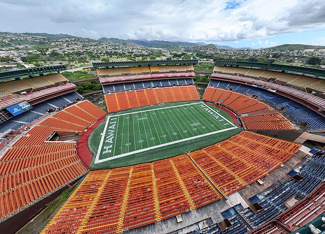
English: Aerial view of Aloha Stadium in a state of abandonment just months before a planned demolition |
| Date | |
| Source | Own work |
| Author | Quintin Soloviev |
| Camera location |
| View this and other nearby images on: OpenStreetMap |
|
|---|
Licensing
I, the copyright holder of this work, hereby publish it under the following license:
This file is licensed under the
Creative Commons
Attribution 4.0 International license.
- You are free:
- to share – to copy, distribute and transmit the work
- to remix – to adapt the work
- Under the following conditions:
- attribution – You must give appropriate credit, provide a link to the license, and indicate if changes were made. You may do so in any reasonable manner, but not in any way that suggests the licensor endorses you or your use.
File history
Click on a date/time to view the file as it appeared at that time.
| Date/Time | Thumbnail | Dimensions | User | Comment | |
|---|---|---|---|---|---|
| current | 08:37, 19 March 2024 |
| 8,000 × 5,760 (37.8 MB) | Quintinsoloviev | Uploaded own work with UploadWizard |
File usage
The following pages on the English Wikipedia use this file (pages on other projects are not listed):
Global file usage
The following other wikis use this file:
- Usage on nl.wikipedia.org
- Usage on pt.wikipedia.org
Metadata
Size of this preview:
800 × 576 pixels. Other resolutions:
320 × 230 pixels |
640 × 461 pixels |
1,024 × 737 pixels |
1,280 × 922 pixels |
2,560 × 1,843 pixels |
8,000 × 5,760 pixels.
Original file (8,000 × 5,760 pixels, file size: 37.8 MB, MIME type: image/jpeg)
| This is a file from the
Wikimedia Commons. Information from its
description page there is shown below. Commons is a freely licensed media file repository. You can help. |
Summary
| Description |
English: Aerial view of Aloha Stadium in a state of abandonment just months before a planned demolition |
| Date | |
| Source | Own work |
| Author | Quintin Soloviev |
| Camera location |
| View this and other nearby images on: OpenStreetMap |
|
|---|
Licensing
I, the copyright holder of this work, hereby publish it under the following license:
This file is licensed under the
Creative Commons
Attribution 4.0 International license.
- You are free:
- to share – to copy, distribute and transmit the work
- to remix – to adapt the work
- Under the following conditions:
- attribution – You must give appropriate credit, provide a link to the license, and indicate if changes were made. You may do so in any reasonable manner, but not in any way that suggests the licensor endorses you or your use.
File history
Click on a date/time to view the file as it appeared at that time.
| Date/Time | Thumbnail | Dimensions | User | Comment | |
|---|---|---|---|---|---|
| current | 08:37, 19 March 2024 |
| 8,000 × 5,760 (37.8 MB) | Quintinsoloviev | Uploaded own work with UploadWizard |
File usage
The following pages on the English Wikipedia use this file (pages on other projects are not listed):
Global file usage
The following other wikis use this file:
- Usage on nl.wikipedia.org
- Usage on pt.wikipedia.org