
Size of this PNG preview of this SVG file:
358 × 284 pixels. Other resolutions:
303 × 240 pixels |
605 × 480 pixels |
968 × 768 pixels |
1,280 × 1,015 pixels |
2,560 × 2,031 pixels.
Original file (SVG file, nominally 358 × 284 pixels, file size: 63 KB)
| This is a file from the
Wikimedia Commons. Information from its
description page there is shown below. Commons is a freely licensed media file repository. You can help. |
Summary
| Description |
Deutsch: Flugplan von
Air-France-Flug 447. Die rote durchgehende Linie zeigt die bereits geflogende Route, die gestrichelte den geplanten Flug nach dem Verschwinden vom Radar.
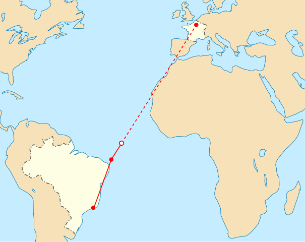
English: Flight path of Air France Flight 447 on 31 May/1 June. The solid red line shows actual route, the dashed line is the planned route after the last transmission heard.
Français : Trajet du vol Air France 447 qui s'est déroulé durant la nuit du 31 mai/1er juin. La ligne rouge continue montre le trajet effectivement effectué, et la ligne pontillé le reste du plan de vol après le dernier contact radar.
Português: Plano de voo para o avião da
Air France - Voo 447 - feito na madrugada de 31 de maio para 1 de junho. A linha vermelha contínua mostra a rota que o avião deveria seguir, e a linha tracejada é a rota prevista para depois do ponto onde o radar perdeu contato com o avião. |
| Date | |
| Source | Self-made in Inkscape, based on File:Air France Flight 447 path.svg |
| Author | Mysid |
| Other versions |
Derivative works of this file: |
Licensing
| I, the copyright holder of this work, release this work into the
public domain. This applies worldwide. In some countries this may not be legally possible; if so: I grant anyone the right to use this work for any purpose, without any conditions, unless such conditions are required by law. |
File history
Click on a date/time to view the file as it appeared at that time.
| Date/Time | Thumbnail | Dimensions | User | Comment | |
|---|---|---|---|---|---|
| current | 09:06, 3 June 2009 |
| 358 × 284 (63 KB) | Mysid | straight lines |
| 09:01, 3 June 2009 |
 | 358 × 284 (63 KB) | Mysid | plotting the location of the last transmission heard | |
| 15:05, 2 June 2009 |
 | 358 × 284 (62 KB) | Mysid | == Summary == {{Information |Description={{en|1=Flight path of Air France Flight 447 on 31 May/1 June. The solid red line shows actual route, the dashed line is the planned route after the last radar contact.}} |Source=Self-made in Inkscape, based on [[:F |
File usage
The following pages on the English Wikipedia use this file (pages on other projects are not listed):
Global file usage
The following other wikis use this file:
- Usage on ar.wikipedia.org
- Usage on az.wikipedia.org
- Usage on be.wikipedia.org
- Usage on eo.wikipedia.org
- Usage on es.wikipedia.org
- Usage on es.wikinews.org
- Usage on fi.wikipedia.org
- Usage on fr.wikipedia.org
- Usage on fr.wikinews.org
- Usage on ko.wikipedia.org
- Usage on no.wikipedia.org
- Usage on pl.wikipedia.org
- Usage on pt.wikipedia.org
- Usage on ru.wikipedia.org
- Usage on sh.wikipedia.org
- Usage on sr.wikipedia.org
- Usage on sv.wikipedia.org
- Usage on ta.wikinews.org
- Usage on vi.wikipedia.org
- Usage on www.wikidata.org
- Usage on wuu.wikipedia.org
Size of this PNG preview of this SVG file:
358 × 284 pixels. Other resolutions:
303 × 240 pixels |
605 × 480 pixels |
968 × 768 pixels |
1,280 × 1,015 pixels |
2,560 × 2,031 pixels.
Original file (SVG file, nominally 358 × 284 pixels, file size: 63 KB)
| This is a file from the
Wikimedia Commons. Information from its
description page there is shown below. Commons is a freely licensed media file repository. You can help. |
Summary
| Description |
Deutsch: Flugplan von
Air-France-Flug 447. Die rote durchgehende Linie zeigt die bereits geflogende Route, die gestrichelte den geplanten Flug nach dem Verschwinden vom Radar.
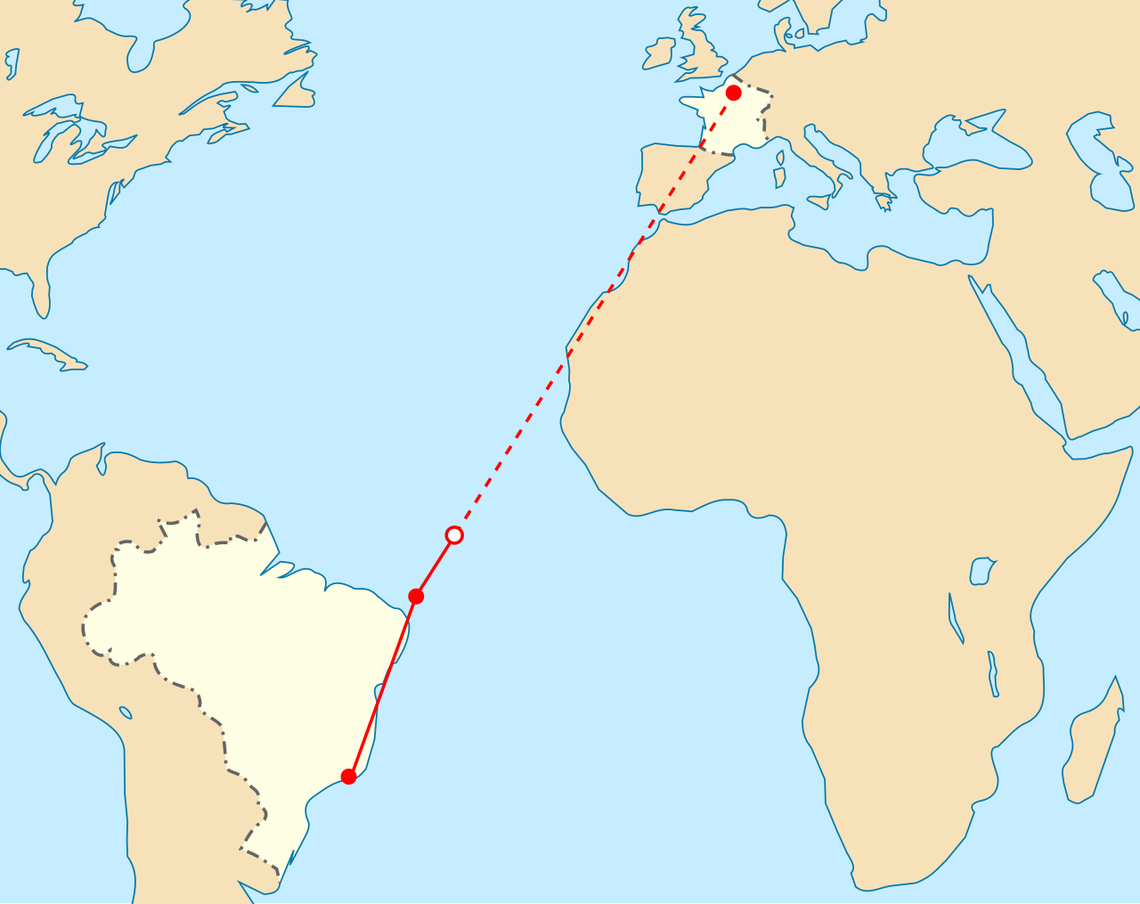
English: Flight path of Air France Flight 447 on 31 May/1 June. The solid red line shows actual route, the dashed line is the planned route after the last transmission heard.
Français : Trajet du vol Air France 447 qui s'est déroulé durant la nuit du 31 mai/1er juin. La ligne rouge continue montre le trajet effectivement effectué, et la ligne pontillé le reste du plan de vol après le dernier contact radar.
Português: Plano de voo para o avião da
Air France - Voo 447 - feito na madrugada de 31 de maio para 1 de junho. A linha vermelha contínua mostra a rota que o avião deveria seguir, e a linha tracejada é a rota prevista para depois do ponto onde o radar perdeu contato com o avião. |
| Date | |
| Source | Self-made in Inkscape, based on File:Air France Flight 447 path.svg |
| Author | Mysid |
| Other versions |
Derivative works of this file: |
Licensing
| I, the copyright holder of this work, release this work into the
public domain. This applies worldwide. In some countries this may not be legally possible; if so: I grant anyone the right to use this work for any purpose, without any conditions, unless such conditions are required by law. |
File history
Click on a date/time to view the file as it appeared at that time.
| Date/Time | Thumbnail | Dimensions | User | Comment | |
|---|---|---|---|---|---|
| current | 09:06, 3 June 2009 |
| 358 × 284 (63 KB) | Mysid | straight lines |
| 09:01, 3 June 2009 |
| 358 × 284 (63 KB) | Mysid | plotting the location of the last transmission heard | |
| 15:05, 2 June 2009 |
| 358 × 284 (62 KB) | Mysid | == Summary == {{Information |Description={{en|1=Flight path of Air France Flight 447 on 31 May/1 June. The solid red line shows actual route, the dashed line is the planned route after the last radar contact.}} |Source=Self-made in Inkscape, based on [[:F |
File usage
The following pages on the English Wikipedia use this file (pages on other projects are not listed):
Global file usage
The following other wikis use this file:
- Usage on ar.wikipedia.org
- Usage on az.wikipedia.org
- Usage on be.wikipedia.org
- Usage on eo.wikipedia.org
- Usage on es.wikipedia.org
- Usage on es.wikinews.org
- Usage on fi.wikipedia.org
- Usage on fr.wikipedia.org
- Usage on fr.wikinews.org
- Usage on ko.wikipedia.org
- Usage on no.wikipedia.org
- Usage on pl.wikipedia.org
- Usage on pt.wikipedia.org
- Usage on ru.wikipedia.org
- Usage on sh.wikipedia.org
- Usage on sr.wikipedia.org
- Usage on sv.wikipedia.org
- Usage on ta.wikinews.org
- Usage on vi.wikipedia.org
- Usage on www.wikidata.org
- Usage on wuu.wikipedia.org