
Size of this preview:
673 × 599 pixels. Other resolutions:
270 × 240 pixels |
539 × 480 pixels |
863 × 768 pixels |
1,150 × 1,024 pixels |
2,300 × 2,048 pixels |
2,808 × 2,500 pixels.
Original file (2,808 × 2,500 pixels, file size: 4.16 MB, MIME type: image/jpeg)
| This is a file from the
Wikimedia Commons. Information from its
description page there is shown below. Commons is a freely licensed media file repository. You can help. |
Summary
| Description |
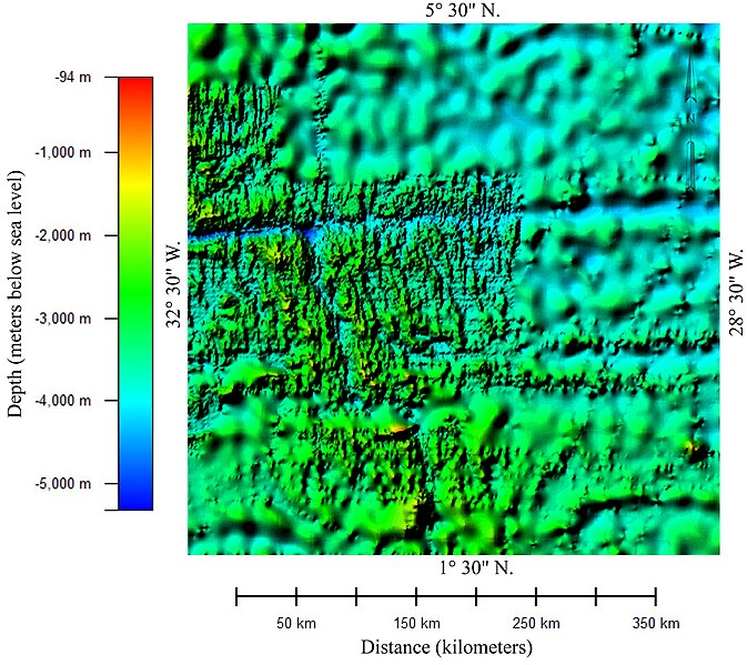
English: Color relief map of the bathymetry of the part of Atlantic Ocean in which Air France Flight 447 crashed. The image shows two different data sets with different resolution. The areas showing detailed bathymetry were mapped using multibeam bathmetry sonar. The areas showing very generalized bathmetry were mapped using high-density satellite altimetry.
This image was prepared from General Bathymetric Chart of the Oceans (GEBCO) compiled by the British Oceanographic Centre. The 30 arc-second gridded bathymetric data was downloaded from "Gridded bathymetric data sets" at
http://www.bodc.ac.uk/data/online_delivery/gebco/. Image was prepared using Global Mapper 8.0 and Adobe Illustrator CS2.
Esperanto: La kolora reliefa mapo de
batimetrio de la parto de la Atlantiko kie kraŝis la
Flugo Air France 447.
Français : Relief bathymétrique en couleur de la portion de l'océan Atlantique dans laquelle a disparu le vol Air France 447. L'image montre deux ensembles de données avec des résolutions différentes. Les zones de bathymétrie de détail ont été cartographiées à l'aide d'un sonar multifaisceaux. Les zones montrant la bathymétrie d'ensemble ont été relevées par un radar altimétrique de haute précision embarqué sur un satellite.
Português: Um mapa
batimétrico de parte do
Oceano Atlântico na região onde o
Voo Air France 447 desapareceu. A imagem mostra dois conjuntos distintos de dados com resoluções diferentes. A área que mostra a batimetria detalhada, mais nítida, foi feita utilizando sonares batimétricos. A área mostrando dados batimétricos mais generalizados foram feitos utilizando satélites altimétricos de alta densidade. Este mapa foi preparado com base na Tabela Geral Batimétrica dos Oceanos (GEBCO, da sigla em inglês) feita pelo Centro Britânico de Oceanografia. Os dados foram gravados de
http://www.bodc.ac.uk/data/online_delivery/gebco/. A imagem foi feita utilizando o software Global Mapper 8.0 e o Adobe Illustrator CS2.
Deutsch: Bathymetrie eines Teil des Atlaniks mit der möglichen Absturzstelle des Flugzeuges des Fluges Air France 447. Durch Sonarabtastung des Meeresbodens druch Satelliten entand diese Reliefkarte unter Zugrundelgung des General Bathymetric Chart of the Oceans [GEBCO] des British Oceanographic Centre. |
| Date | |
| Source | Own work |
| Author | Paradoxides |
Licensing
I, the copyright holder of this work, hereby publish it under the following licenses:
This file is licensed under the
Creative Commons
Attribution-Share Alike 3.0 Unported license.
- You are free:
- to share – to copy, distribute and transmit the work
- to remix – to adapt the work
- Under the following conditions:
- attribution – You must give appropriate credit, provide a link to the license, and indicate if changes were made. You may do so in any reasonable manner, but not in any way that suggests the licensor endorses you or your use.
- share alike – If you remix, transform, or build upon the material, you must distribute your contributions under the same or compatible license as the original.

|
Permission is granted to copy, distribute and/or modify this document under the terms of the GNU Free Documentation License, Version 1.2 or any later version published by the Free Software Foundation; with no Invariant Sections, no Front-Cover Texts, and no Back-Cover Texts. A copy of the license is included in the section entitled GNU Free Documentation License. |
You may select the license of your choice.
File history
Click on a date/time to view the file as it appeared at that time.
| Date/Time | Thumbnail | Dimensions | User | Comment | |
|---|---|---|---|---|---|
| current | 04:05, 6 June 2009 |
| 2,808 × 2,500 (4.16 MB) | Paradoxides~commonswiki | Replaced previous image because longitude text clipped on right edge. |
| 02:44, 6 June 2009 |
 | 2,803 × 2,500 (4.16 MB) | Paradoxides~commonswiki | Added captions to clarify scales on mmap | |
| 02:29, 6 June 2009 |
 | 1,311 × 1,198 (1.81 MB) | Paradoxides~commonswiki | {{Information |Description={{en|1=Color relief map of the bathymetry of the part of Atlantic Ocean in which Air France Flight crashed. The image shows two different data sets with different resolution. The areas showing detailed bathymetry were mapped usi |
File usage
The following pages on the English Wikipedia use this file (pages on other projects are not listed):
Global file usage
The following other wikis use this file:
- Usage on de.wikipedia.org
- Usage on eo.wikipedia.org
- Usage on fr.wikipedia.org
- Usage on sv.wikipedia.org
- Usage on www.wikidata.org
Metadata
Size of this preview:
673 × 599 pixels. Other resolutions:
270 × 240 pixels |
539 × 480 pixels |
863 × 768 pixels |
1,150 × 1,024 pixels |
2,300 × 2,048 pixels |
2,808 × 2,500 pixels.
Original file (2,808 × 2,500 pixels, file size: 4.16 MB, MIME type: image/jpeg)
| This is a file from the
Wikimedia Commons. Information from its
description page there is shown below. Commons is a freely licensed media file repository. You can help. |
Summary
| Description |
English: Color relief map of the bathymetry of the part of Atlantic Ocean in which Air France Flight 447 crashed. The image shows two different data sets with different resolution. The areas showing detailed bathymetry were mapped using multibeam bathmetry sonar. The areas showing very generalized bathmetry were mapped using high-density satellite altimetry.
This image was prepared from General Bathymetric Chart of the Oceans (GEBCO) compiled by the British Oceanographic Centre. The 30 arc-second gridded bathymetric data was downloaded from "Gridded bathymetric data sets" at
http://www.bodc.ac.uk/data/online_delivery/gebco/. Image was prepared using Global Mapper 8.0 and Adobe Illustrator CS2.
Esperanto: La kolora reliefa mapo de
batimetrio de la parto de la Atlantiko kie kraŝis la
Flugo Air France 447.
Français : Relief bathymétrique en couleur de la portion de l'océan Atlantique dans laquelle a disparu le vol Air France 447. L'image montre deux ensembles de données avec des résolutions différentes. Les zones de bathymétrie de détail ont été cartographiées à l'aide d'un sonar multifaisceaux. Les zones montrant la bathymétrie d'ensemble ont été relevées par un radar altimétrique de haute précision embarqué sur un satellite.
Português: Um mapa
batimétrico de parte do
Oceano Atlântico na região onde o
Voo Air France 447 desapareceu. A imagem mostra dois conjuntos distintos de dados com resoluções diferentes. A área que mostra a batimetria detalhada, mais nítida, foi feita utilizando sonares batimétricos. A área mostrando dados batimétricos mais generalizados foram feitos utilizando satélites altimétricos de alta densidade. Este mapa foi preparado com base na Tabela Geral Batimétrica dos Oceanos (GEBCO, da sigla em inglês) feita pelo Centro Britânico de Oceanografia. Os dados foram gravados de
http://www.bodc.ac.uk/data/online_delivery/gebco/. A imagem foi feita utilizando o software Global Mapper 8.0 e o Adobe Illustrator CS2.
Deutsch: Bathymetrie eines Teil des Atlaniks mit der möglichen Absturzstelle des Flugzeuges des Fluges Air France 447. Durch Sonarabtastung des Meeresbodens druch Satelliten entand diese Reliefkarte unter Zugrundelgung des General Bathymetric Chart of the Oceans [GEBCO] des British Oceanographic Centre. |
| Date | |
| Source | Own work |
| Author | Paradoxides |
Licensing
I, the copyright holder of this work, hereby publish it under the following licenses:
This file is licensed under the
Creative Commons
Attribution-Share Alike 3.0 Unported license.
- You are free:
- to share – to copy, distribute and transmit the work
- to remix – to adapt the work
- Under the following conditions:
- attribution – You must give appropriate credit, provide a link to the license, and indicate if changes were made. You may do so in any reasonable manner, but not in any way that suggests the licensor endorses you or your use.
- share alike – If you remix, transform, or build upon the material, you must distribute your contributions under the same or compatible license as the original.
|
|
Permission is granted to copy, distribute and/or modify this document under the terms of the GNU Free Documentation License, Version 1.2 or any later version published by the Free Software Foundation; with no Invariant Sections, no Front-Cover Texts, and no Back-Cover Texts. A copy of the license is included in the section entitled GNU Free Documentation License. |
You may select the license of your choice.
File history
Click on a date/time to view the file as it appeared at that time.
| Date/Time | Thumbnail | Dimensions | User | Comment | |
|---|---|---|---|---|---|
| current | 04:05, 6 June 2009 |
| 2,808 × 2,500 (4.16 MB) | Paradoxides~commonswiki | Replaced previous image because longitude text clipped on right edge. |
| 02:44, 6 June 2009 |
| 2,803 × 2,500 (4.16 MB) | Paradoxides~commonswiki | Added captions to clarify scales on mmap | |
| 02:29, 6 June 2009 |
| 1,311 × 1,198 (1.81 MB) | Paradoxides~commonswiki | {{Information |Description={{en|1=Color relief map of the bathymetry of the part of Atlantic Ocean in which Air France Flight crashed. The image shows two different data sets with different resolution. The areas showing detailed bathymetry were mapped usi |
File usage
The following pages on the English Wikipedia use this file (pages on other projects are not listed):
Global file usage
The following other wikis use this file:
- Usage on de.wikipedia.org
- Usage on eo.wikipedia.org
- Usage on fr.wikipedia.org
- Usage on sv.wikipedia.org
- Usage on www.wikidata.org