
Size of this preview:
800 × 486 pixels. Other resolutions:
320 × 195 pixels |
640 × 389 pixels |
1,024 × 622 pixels |
1,280 × 778 pixels |
2,560 × 1,556 pixels |
15,200 × 9,239 pixels.
Original file (15,200 × 9,239 pixels, file size: 16.32 MB, MIME type: image/png)
| This is a file from the
Wikimedia Commons. Information from its
description page there is shown below. Commons is a freely licensed media file repository. You can help. |
Summary
| Warning | The original file is very high-resolution. It might not load properly or could cause your browser to freeze when opened at full size. |
|---|
| Description |
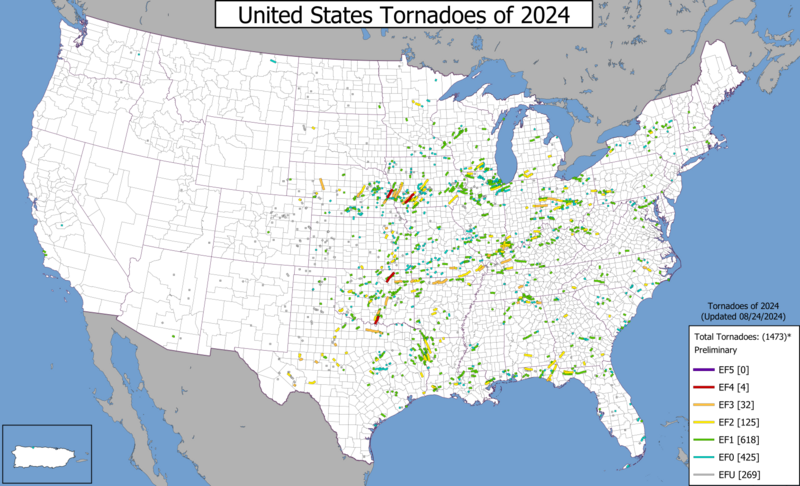
English: Map of United States tornado tracks during 2024. Data sourced from storm surveys conducted by regional NWS offices. |
| Date | |
| Source | Own work |
| Author | Supportstorm |
Licensing
I, the copyright holder of this work, hereby publish it under the following license:
| This file is made available under the Creative Commons CC0 1.0 Universal Public Domain Dedication. | |
| The person who associated a work with this deed has dedicated the work to the
public domain by waiving all of their rights to the work worldwide under copyright law, including all related and neighboring rights, to the extent allowed by law. You can copy, modify, distribute and perform the work, even for commercial purposes, all without asking permission.
|
File history
Click on a date/time to view the file as it appeared at that time.
| Date/Time | Thumbnail | Dimensions | User | Comment | |
|---|---|---|---|---|---|
| current | 03:40, 16 July 2024 |
| 15,200 × 9,239 (16.32 MB) | Supportstorm | Updated (07/15/2024) |
| 06:55, 15 June 2024 |
 | 15,200 × 9,239 (16.1 MB) | Supportstorm | Updated (06/14/2024) | |
| 05:10, 29 May 2024 |
 | 15,200 × 9,239 (15.96 MB) | Supportstorm | Updated (05/28/2024) | |
| 05:38, 24 May 2024 |
 | 15,200 × 9,239 (15.75 MB) | Supportstorm | Updated (2024/05/23) | |
| 23:52, 29 March 2024 |
 | 15,200 × 9,239 (14.83 MB) | Supportstorm | Fixed typo | |
| 23:02, 29 March 2024 |
 | 15,200 × 9,239 (14.83 MB) | Supportstorm | Updated (03/29/2024) | |
| 05:13, 27 February 2024 |
 | 15,200 × 9,239 (14.59 MB) | Supportstorm | == {{int:filedesc}} == {{LargeImage}} {{Information |description ={{en|1=Map of United States tornado tracks during 2024. Data sourced from storm surveys conducted by regional NWS offices.}} |date =2024-02-27 |source ={{own}} |author = Supportstorm }} == {{int:license-header}} == {{self|Cc-zero}} Category:Tornadoes of 2024 Category:2024 maps of the United States Category:Tornado track maps |
File usage
The following pages on the English Wikipedia use this file (pages on other projects are not listed):
Metadata
Size of this preview:
800 × 486 pixels. Other resolutions:
320 × 195 pixels |
640 × 389 pixels |
1,024 × 622 pixels |
1,280 × 778 pixels |
2,560 × 1,556 pixels |
15,200 × 9,239 pixels.
Original file (15,200 × 9,239 pixels, file size: 16.32 MB, MIME type: image/png)
| This is a file from the
Wikimedia Commons. Information from its
description page there is shown below. Commons is a freely licensed media file repository. You can help. |
Summary
| Warning | The original file is very high-resolution. It might not load properly or could cause your browser to freeze when opened at full size. |
|---|
| Description |
English: Map of United States tornado tracks during 2024. Data sourced from storm surveys conducted by regional NWS offices. |
| Date | |
| Source | Own work |
| Author | Supportstorm |
Licensing
I, the copyright holder of this work, hereby publish it under the following license:
| This file is made available under the Creative Commons CC0 1.0 Universal Public Domain Dedication. | |
| The person who associated a work with this deed has dedicated the work to the
public domain by waiving all of their rights to the work worldwide under copyright law, including all related and neighboring rights, to the extent allowed by law. You can copy, modify, distribute and perform the work, even for commercial purposes, all without asking permission.
|
File history
Click on a date/time to view the file as it appeared at that time.
| Date/Time | Thumbnail | Dimensions | User | Comment | |
|---|---|---|---|---|---|
| current | 03:40, 16 July 2024 |
| 15,200 × 9,239 (16.32 MB) | Supportstorm | Updated (07/15/2024) |
| 06:55, 15 June 2024 |
| 15,200 × 9,239 (16.1 MB) | Supportstorm | Updated (06/14/2024) | |
| 05:10, 29 May 2024 |
| 15,200 × 9,239 (15.96 MB) | Supportstorm | Updated (05/28/2024) | |
| 05:38, 24 May 2024 |
| 15,200 × 9,239 (15.75 MB) | Supportstorm | Updated (2024/05/23) | |
| 23:52, 29 March 2024 |
| 15,200 × 9,239 (14.83 MB) | Supportstorm | Fixed typo | |
| 23:02, 29 March 2024 |
| 15,200 × 9,239 (14.83 MB) | Supportstorm | Updated (03/29/2024) | |
| 05:13, 27 February 2024 |
| 15,200 × 9,239 (14.59 MB) | Supportstorm | == {{int:filedesc}} == {{LargeImage}} {{Information |description ={{en|1=Map of United States tornado tracks during 2024. Data sourced from storm surveys conducted by regional NWS offices.}} |date =2024-02-27 |source ={{own}} |author = Supportstorm }} == {{int:license-header}} == {{self|Cc-zero}} Category:Tornadoes of 2024 Category:2024 maps of the United States Category:Tornado track maps |
File usage
The following pages on the English Wikipedia use this file (pages on other projects are not listed):