
Original file (845 × 910 pixels, file size: 209 KB, MIME type: image/jpeg)
| This is a file from the
Wikimedia Commons. Information from its
description page there is shown below. Commons is a freely licensed media file repository. You can help. |
Summary
| Description |
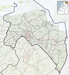
Nederlands: Referentiekaart van Provincie Groningen, met indeling van gemeenten (2010) en impressie van het landschap.
Door Jan-Willem van Aalst, samengesteld uit publiek beschikbare geo-data:
|
| Source | Own work |
| Author | Janwillemvanaalst |
Licensing
- You are free:
- to share – to copy, distribute and transmit the work
- to remix – to adapt the work
- Under the following conditions:
- attribution – You must give appropriate credit, provide a link to the license, and indicate if changes were made. You may do so in any reasonable manner, but not in any way that suggests the licensor endorses you or your use.
- share alike – If you remix, transform, or build upon the material, you must distribute your contributions under the same or compatible license as the original.
File history
Click on a date/time to view the file as it appeared at that time.
| Date/Time | Thumbnail | Dimensions | User | Comment | |
|---|---|---|---|---|---|
| current | 20:17, 15 January 2010 |
| 845 × 910 (209 KB) | Janwillemvanaalst | {{Information |Description={{nl|1=Referentiekaart van Provincie Groningen, met indeling van gemeenten (2010) en impressie van het landschap. Door Jan-Willem van Aalst, samengesteld uit publiek beschikbare geo-data: * Referentie-ondergrond (kustlijn, stede |
File usage
More than 100 pages use this file. The following list shows the first 100 pages that use this file only. A full list is available.
- Adorp
- Aduard
- Agodorp
- Appingedam
- Bad Nieuweschans
- Baflo
- Barnflair
- Bedum
- Beerta
- Bellingwolde
- Bierum
- Biessum
- Borgsweer
- Bourtange
- Buinerveen
- Burgemeester Beinsdorp
- De Langeleegte
- De Maten
- Denemarken
- Eemshaven
- Eenrum
- Ellersinghuizen
- Eppenhuizen
- Euroborg
- Ezinge
- Farmsum
- Fraeylemaborg
- Godlinze
- Grijpskerk
- Groninger Museum
- Haren, Groningen
- Harkstede
- Harpel
- Hebrecht
- Heiligerlee
- Hellum
- Holwierde
- Hoogezand
- Hoogkerk
- Jipsingboertange
- Jipsinghuizen
- Kantens
- Kloosterburen
- Krewerd
- Kropswolde
- Laude, Netherlands
- Laudermarke
- Leek, Netherlands
- Leens
- Loppersum
- Losdorp
- Lutjegast
- Martenshoek
- Marum
- Meeden
- Meedhuizen
- Menkemaborg
- Middelstum
- Midwolda
- Munnekemoer
- Muntendam
- Nieuwe Pekela
- Nieuwolda
- Noordlaren
- Opende
- Pallert
- Pieterburen
- Roodeschool
- Rottum, Groningen
- Sappemeer
- Sauwerd
- Scheemda
- Sellingen
- Sellingerbeetse
- Spijk, Groningen
- Stadion Oosterpark
- Stakenborg
- Ten Boer
- Ter Apel
- Ter Apelkanaal
- Ter Wisch
- Termunten
- Termunterzijl
- Uithuizen
- Uithuizermeeden
- Uitwierde
- Ulrum
- Usquert
- Veele
- Vlagtwedde
- Vlagtwedder-Veldhuis
- Wagenborgen
- Warffum
- Warfhuizen
- Weite
- Weiwerd
- Wildervank
- Winschoten
- Woldendorp
- Wollinghuizen
View more links to this file.
Global file usage
The following other wikis use this file:
- Usage on ar.wikipedia.org
- Usage on azb.wikipedia.org
- Usage on ceb.wikipedia.org
- Usage on fa.wikipedia.org
- ادراپ
- هت زانت
- ترمونترزیل
- آیتهایزن
- آیتهایزرمیدن
- میدهایزن
- بلاوهاستاد
- بلینگولده
- مونتندام
- آودهاسخانس
- واخنبورخن
- آیتویرده
- فیلرفین
- فریسهلو
- زیلدیک
- رودهاسخول
- نوردپلدرزیل
- ریدربروخ
- وستردیپستردالن
- وارفهایزن
- وارفوم
- خارنورد
- ودرفیر
- میدلستوم
- استرنیلاند
- بورخرکمپانی
- هوخهزاند
- بلیهام
- نوردلارن
- خودلینزه
- وینسخوتن
- اوسکوئرت
- اولروم
- استوم
- انستوده
- خریپسکرک
- هیلیخرلی
- وستینگه
- وینهویر
- زیریپ
- ولدندورپ
- مارتنسهوک
- ابرخوم
- خلیمن
- منسینگهویر
- دورکورد
- دینهمارکن
View more global usage of this file.
Metadata
Original file (845 × 910 pixels, file size: 209 KB, MIME type: image/jpeg)
| This is a file from the
Wikimedia Commons. Information from its
description page there is shown below. Commons is a freely licensed media file repository. You can help. |
Summary
| Description |
Nederlands: Referentiekaart van Provincie Groningen, met indeling van gemeenten (2010) en impressie van het landschap.
Door Jan-Willem van Aalst, samengesteld uit publiek beschikbare geo-data:
|
| Source | Own work |
| Author | Janwillemvanaalst |
Licensing
- You are free:
- to share – to copy, distribute and transmit the work
- to remix – to adapt the work
- Under the following conditions:
- attribution – You must give appropriate credit, provide a link to the license, and indicate if changes were made. You may do so in any reasonable manner, but not in any way that suggests the licensor endorses you or your use.
- share alike – If you remix, transform, or build upon the material, you must distribute your contributions under the same or compatible license as the original.
File history
Click on a date/time to view the file as it appeared at that time.
| Date/Time | Thumbnail | Dimensions | User | Comment | |
|---|---|---|---|---|---|
| current | 20:17, 15 January 2010 |
| 845 × 910 (209 KB) | Janwillemvanaalst | {{Information |Description={{nl|1=Referentiekaart van Provincie Groningen, met indeling van gemeenten (2010) en impressie van het landschap. Door Jan-Willem van Aalst, samengesteld uit publiek beschikbare geo-data: * Referentie-ondergrond (kustlijn, stede |
File usage
More than 100 pages use this file. The following list shows the first 100 pages that use this file only. A full list is available.
- Adorp
- Aduard
- Agodorp
- Appingedam
- Bad Nieuweschans
- Baflo
- Barnflair
- Bedum
- Beerta
- Bellingwolde
- Bierum
- Biessum
- Borgsweer
- Bourtange
- Buinerveen
- Burgemeester Beinsdorp
- De Langeleegte
- De Maten
- Denemarken
- Eemshaven
- Eenrum
- Ellersinghuizen
- Eppenhuizen
- Euroborg
- Ezinge
- Farmsum
- Fraeylemaborg
- Godlinze
- Grijpskerk
- Groninger Museum
- Haren, Groningen
- Harkstede
- Harpel
- Hebrecht
- Heiligerlee
- Hellum
- Holwierde
- Hoogezand
- Hoogkerk
- Jipsingboertange
- Jipsinghuizen
- Kantens
- Kloosterburen
- Krewerd
- Kropswolde
- Laude, Netherlands
- Laudermarke
- Leek, Netherlands
- Leens
- Loppersum
- Losdorp
- Lutjegast
- Martenshoek
- Marum
- Meeden
- Meedhuizen
- Menkemaborg
- Middelstum
- Midwolda
- Munnekemoer
- Muntendam
- Nieuwe Pekela
- Nieuwolda
- Noordlaren
- Opende
- Pallert
- Pieterburen
- Roodeschool
- Rottum, Groningen
- Sappemeer
- Sauwerd
- Scheemda
- Sellingen
- Sellingerbeetse
- Spijk, Groningen
- Stadion Oosterpark
- Stakenborg
- Ten Boer
- Ter Apel
- Ter Apelkanaal
- Ter Wisch
- Termunten
- Termunterzijl
- Uithuizen
- Uithuizermeeden
- Uitwierde
- Ulrum
- Usquert
- Veele
- Vlagtwedde
- Vlagtwedder-Veldhuis
- Wagenborgen
- Warffum
- Warfhuizen
- Weite
- Weiwerd
- Wildervank
- Winschoten
- Woldendorp
- Wollinghuizen
View more links to this file.
Global file usage
The following other wikis use this file:
- Usage on ar.wikipedia.org
- Usage on azb.wikipedia.org
- Usage on ceb.wikipedia.org
- Usage on fa.wikipedia.org
- ادراپ
- هت زانت
- ترمونترزیل
- آیتهایزن
- آیتهایزرمیدن
- میدهایزن
- بلاوهاستاد
- بلینگولده
- مونتندام
- آودهاسخانس
- واخنبورخن
- آیتویرده
- فیلرفین
- فریسهلو
- زیلدیک
- رودهاسخول
- نوردپلدرزیل
- ریدربروخ
- وستردیپستردالن
- وارفهایزن
- وارفوم
- خارنورد
- ودرفیر
- میدلستوم
- استرنیلاند
- بورخرکمپانی
- هوخهزاند
- بلیهام
- نوردلارن
- خودلینزه
- وینسخوتن
- اوسکوئرت
- اولروم
- استوم
- انستوده
- خریپسکرک
- هیلیخرلی
- وستینگه
- وینهویر
- زیریپ
- ولدندورپ
- مارتنسهوک
- ابرخوم
- خلیمن
- منسینگهویر
- دورکورد
- دینهمارکن
View more global usage of this file.