
Original file (1,275 × 1,650 pixels, file size: 495 KB, MIME type: image/jpeg)
| This is a file from the
Wikimedia Commons. Information from its
description page there is shown below. Commons is a freely licensed media file repository. You can help. |
Summary
| Description |
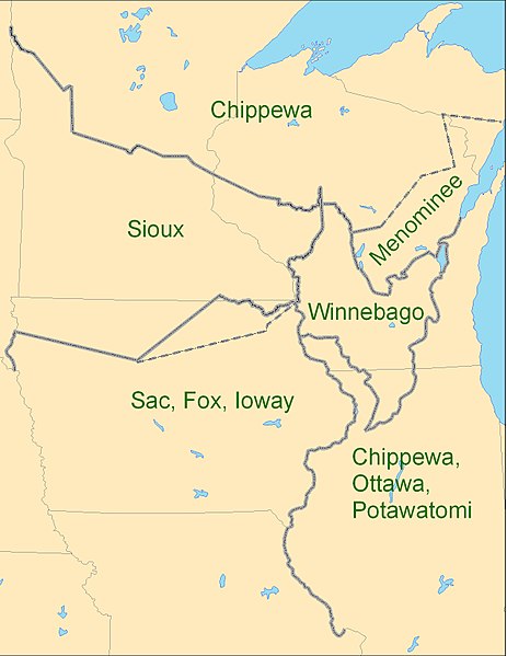
English: Map showing the boundaries between the Sioux (
Dakota), Chippewa (
Ojibwe), Winnebago (
Ho-chunk), Menominee (
Menomini), Sauk and Fox (
Sac and Fox Nation),
Ioway, and the Chippewa-Ottawa-Potawatomi (
Council of Three Fires) as per 1825
Treaty of Prairie du Chien |
| Date | |
| Source | Own work |
| Author | CJLippert |
Due to uncertainty of Menominee and Ioway boundaries, the parties agreed to adjustments to the 1825-established Prairie du Chien Line once the Menominee and Ioway have determined their boundaries. The adjustment lines shown as dashed boundaries.
Licensing
- You are free:
- to share – to copy, distribute and transmit the work
- to remix – to adapt the work
- Under the following conditions:
- attribution – You must give appropriate credit, provide a link to the license, and indicate if changes were made. You may do so in any reasonable manner, but not in any way that suggests the licensor endorses you or your use.
File history
Click on a date/time to view the file as it appeared at that time.
| Date/Time | Thumbnail | Dimensions | User | Comment | |
|---|---|---|---|---|---|
| current | 19:26, 3 September 2009 |
| 1,275 × 1,650 (495 KB) | CJLippert | {{Information |Description={{en|1=Map showing the boundaries between the Sioux ( w:Dakota), Chippewa ( w:Ojibwe), Winnebago ( w:Ho-chunk), Menominee ( w:Menomini), Sauk and Fox ( w:Sac and Fox Nation), w:Ioway, and the Chippewa-Ottawa-P |
File usage
Global file usage
The following other wikis use this file:
- Usage on ca.wikipedia.org
- Usage on en.wikiversity.org
- Usage on es.wikipedia.org
- Usage on fr.wikipedia.org
- Usage on hr.wikipedia.org
- Usage on nl.wikipedia.org
- Usage on oc.wikipedia.org
- Usage on sv.wikipedia.org
- Usage on uk.wikipedia.org
Original file (1,275 × 1,650 pixels, file size: 495 KB, MIME type: image/jpeg)
| This is a file from the
Wikimedia Commons. Information from its
description page there is shown below. Commons is a freely licensed media file repository. You can help. |
Summary
| Description |
English: Map showing the boundaries between the Sioux (
Dakota), Chippewa (
Ojibwe), Winnebago (
Ho-chunk), Menominee (
Menomini), Sauk and Fox (
Sac and Fox Nation),
Ioway, and the Chippewa-Ottawa-Potawatomi (
Council of Three Fires) as per 1825
Treaty of Prairie du Chien |
| Date | |
| Source | Own work |
| Author | CJLippert |
Due to uncertainty of Menominee and Ioway boundaries, the parties agreed to adjustments to the 1825-established Prairie du Chien Line once the Menominee and Ioway have determined their boundaries. The adjustment lines shown as dashed boundaries.
Licensing
- You are free:
- to share – to copy, distribute and transmit the work
- to remix – to adapt the work
- Under the following conditions:
- attribution – You must give appropriate credit, provide a link to the license, and indicate if changes were made. You may do so in any reasonable manner, but not in any way that suggests the licensor endorses you or your use.
File history
Click on a date/time to view the file as it appeared at that time.
| Date/Time | Thumbnail | Dimensions | User | Comment | |
|---|---|---|---|---|---|
| current | 19:26, 3 September 2009 |
| 1,275 × 1,650 (495 KB) | CJLippert | {{Information |Description={{en|1=Map showing the boundaries between the Sioux ( w:Dakota), Chippewa ( w:Ojibwe), Winnebago ( w:Ho-chunk), Menominee ( w:Menomini), Sauk and Fox ( w:Sac and Fox Nation), w:Ioway, and the Chippewa-Ottawa-P |
File usage
Global file usage
The following other wikis use this file:
- Usage on ca.wikipedia.org
- Usage on en.wikiversity.org
- Usage on es.wikipedia.org
- Usage on fr.wikipedia.org
- Usage on hr.wikipedia.org
- Usage on nl.wikipedia.org
- Usage on oc.wikipedia.org
- Usage on sv.wikipedia.org
- Usage on uk.wikipedia.org