
Size of this preview:
800 × 568 pixels. Other resolutions:
320 × 227 pixels |
640 × 454 pixels |
810 × 575 pixels.
Original file (810 × 575 pixels, file size: 865 KB, MIME type: image/png)
| This is a file from the
Wikimedia Commons. Information from its
description page there is shown below. Commons is a freely licensed media file repository. You can help. |
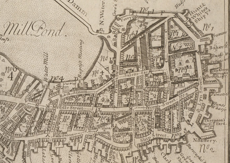
| Description | Detail of 1743 map of Boston by William Price, showing the North End and vicinity. |
| Date | |
| Source | Boston Public Library / http://maps.bpl.org/details_10913 |
| Author | William Price |
|
This work is in the public domain in its country of origin and other countries and areas where the copyright term is the author's life plus 100 years or fewer. | |
| This file has been identified as being free of known restrictions under copyright law, including all related and neighboring rights. | |
File history
Click on a date/time to view the file as it appeared at that time.
| Date/Time | Thumbnail | Dimensions | User | Comment | |
|---|---|---|---|---|---|
| current | 15:46, 18 October 2009 |
| 810 × 575 (865 KB) | M2545 | {{Information |Description=Detail of 1743 map of Boston by William Price, showing the North End and vicinity. |Source=http://maps.bpl.org/details_10913/?dl_pp=1&mtid=5 |Date=1743 |Author=Price |Permission= |other_versions= }} [[Category:Old maps of Boston |
File usage
The following pages on the English Wikipedia use this file (pages on other projects are not listed):
Size of this preview:
800 × 568 pixels. Other resolutions:
320 × 227 pixels |
640 × 454 pixels |
810 × 575 pixels.
Original file (810 × 575 pixels, file size: 865 KB, MIME type: image/png)
| This is a file from the
Wikimedia Commons. Information from its
description page there is shown below. Commons is a freely licensed media file repository. You can help. |
| Description | Detail of 1743 map of Boston by William Price, showing the North End and vicinity. |
| Date | |
| Source | Boston Public Library / http://maps.bpl.org/details_10913 |
| Author | William Price |
|
This work is in the public domain in its country of origin and other countries and areas where the copyright term is the author's life plus 100 years or fewer. | |
| This file has been identified as being free of known restrictions under copyright law, including all related and neighboring rights. | |
File history
Click on a date/time to view the file as it appeared at that time.
| Date/Time | Thumbnail | Dimensions | User | Comment | |
|---|---|---|---|---|---|
| current | 15:46, 18 October 2009 |
| 810 × 575 (865 KB) | M2545 | {{Information |Description=Detail of 1743 map of Boston by William Price, showing the North End and vicinity. |Source=http://maps.bpl.org/details_10913/?dl_pp=1&mtid=5 |Date=1743 |Author=Price |Permission= |other_versions= }} [[Category:Old maps of Boston |
File usage
The following pages on the English Wikipedia use this file (pages on other projects are not listed):