Photos • Location


Size of this preview:
800 √ó 532 pixels. Other resolutions:
320 √ó 213 pixels |
640 √ó 425 pixels |
1,024 √ó 680 pixels |
1,280 √ó 851 pixels |
2,560 √ó 1,701 pixels |
4,912 √ó 3,264 pixels.
Original file (4,912 √ó 3,264 pixels, file size: 8.43 MB, MIME type: image/jpeg)
| This is a file from the
Wikimedia Commons. Information from its
description page there is shown below. Commons is a freely licensed media file repository. You can help. |
Summary
| Description |
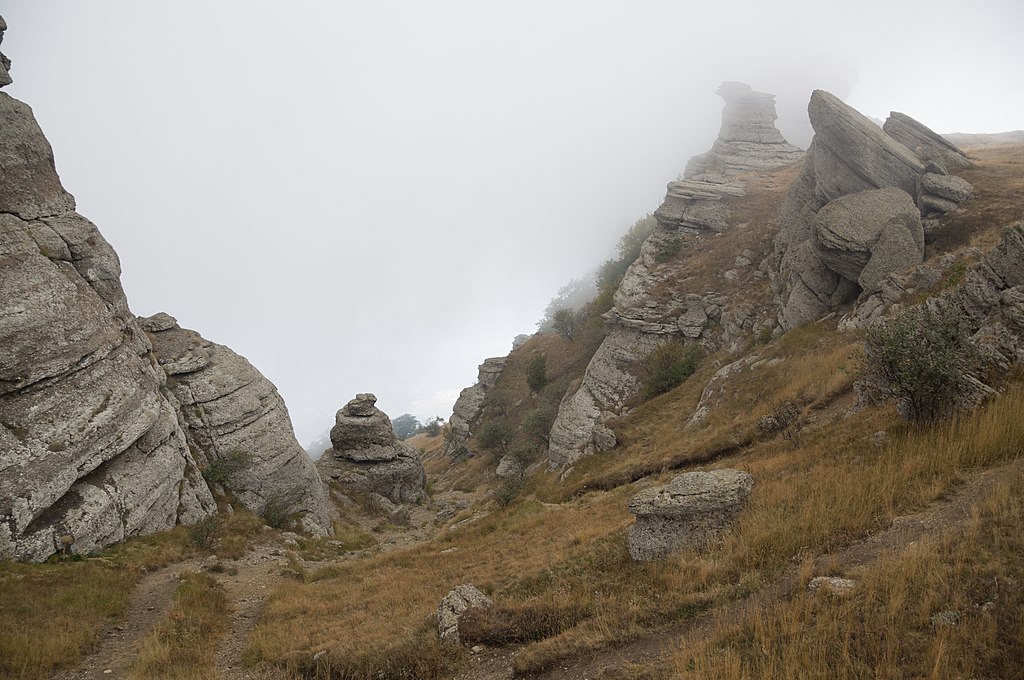
–†—É—Ā—Ā–ļ–ł–Ļ: "–Ē–ĺ–Ľ–ł–Ĺ–į –Ņ—Ä–ł–≤–ł–ī–Ķ–Ĺ–ł–Ļ", –£—Ä–ĺ—á–ł—Č–Ķ –ł –≥–Ķ–ĺ–Ľ–ĺ–≥–ł—á–Ķ—Ā–ļ–ł–Ļ –Ņ–į–ľ—Ź—ā–Ĺ–ł–ļ –Ē–Ķ–ľ–Ķ—Ä–ī–∂–ł, –ö—Ä—č–ľ. –§–ĺ—Ä–ľ—č –≤—č–≤–Ķ—ā—Ä–ł–≤–į–Ĺ–ł—Ź –≤–Ķ—Ä—Ö–Ĺ–Ķ—é—Ä—Ā–ļ–ł—Ö –ļ–ĺ–Ĺ–≥–Ľ–ĺ–ľ–Ķ—Ä–į—ā–ĺ–≤. –í–ĺ–∑—Ä–į—Ā—ā –Ĺ–Ķ–ļ–ĺ—ā–ĺ—Ä—č—Ö –≥—Ä–į–Ĺ–ł—ā–Ĺ—č—Ö –≤–į–Ľ—É–Ĺ–ĺ–≤ - –Ņ–ĺ—Ä—Ź–ī–ļ–į 1 –ľ–ł–Ľ–Ľ–ł–į—Ä–ī–į –Ľ–Ķ—ā.
English: Demerdzhi, Crimea. A place of frequent fog, haze and special atmospheric and lighting conditions. The rocky valley is formed of the conglomerates of sandstone, limestone, quartzite and pink granite. Like many other Crimean mountain ridges Demerdzhi was formed in Late Jurassic some 150 million years ago but it is believed that some granite magma intrusions are up to 1 billion years old (Tonian Neoproterozoic).
|
||
| Date | Taken on 13 September 2014, 16:09:14 | ||
| Source | Own work | ||
| Author | Vyacheslav Argenberg |
| Camera location |
| View this and other nearby images on: OpenStreetMap |
|
|---|

|
This image was taken by
Vyacheslav Argenberg
If you have any questions, comments or queries, please contact me. |

|
Licensing
Vyacheslav Argenberg, the copyright holder of this work, hereby publishes it under the following license:
This file is licensed under the
Creative Commons
Attribution 4.0 International license.
Attribution: © Vyacheslav Argenberg /
http://www.vascoplanet.com/
- You are free:
- to share ‚Äď to copy, distribute and transmit the work
- to remix ‚Äď to adapt the work
- Under the following conditions:
- attribution ‚Äď You must give appropriate credit, provide a link to the license, and indicate if changes were made. You may do so in any reasonable manner, but not in any way that suggests the licensor endorses you or your use.
|
|
This image was uploaded as part of
Wiki Loves Earth 2020.
|
 |
File history
Click on a date/time to view the file as it appeared at that time.
| Date/Time | Thumbnail | Dimensions | User | Comment | |
|---|---|---|---|---|---|
| current | 20:20, 27 June 2020 |
| 4,912 √ó 3,264 (8.43 MB) | Argenberg | Uploaded own work with UploadWizard |
File usage
The following pages on the English Wikipedia use this file (pages on other projects are not listed):
Metadata
Size of this preview:
800 √ó 532 pixels. Other resolutions:
320 √ó 213 pixels |
640 √ó 425 pixels |
1,024 √ó 680 pixels |
1,280 √ó 851 pixels |
2,560 √ó 1,701 pixels |
4,912 √ó 3,264 pixels.
Original file (4,912 √ó 3,264 pixels, file size: 8.43 MB, MIME type: image/jpeg)
| This is a file from the
Wikimedia Commons. Information from its
description page there is shown below. Commons is a freely licensed media file repository. You can help. |
Summary
| Description |
–†—É—Ā—Ā–ļ–ł–Ļ: "–Ē–ĺ–Ľ–ł–Ĺ–į –Ņ—Ä–ł–≤–ł–ī–Ķ–Ĺ–ł–Ļ", –£—Ä–ĺ—á–ł—Č–Ķ –ł –≥–Ķ–ĺ–Ľ–ĺ–≥–ł—á–Ķ—Ā–ļ–ł–Ļ –Ņ–į–ľ—Ź—ā–Ĺ–ł–ļ –Ē–Ķ–ľ–Ķ—Ä–ī–∂–ł, –ö—Ä—č–ľ. –§–ĺ—Ä–ľ—č –≤—č–≤–Ķ—ā—Ä–ł–≤–į–Ĺ–ł—Ź –≤–Ķ—Ä—Ö–Ĺ–Ķ—é—Ä—Ā–ļ–ł—Ö –ļ–ĺ–Ĺ–≥–Ľ–ĺ–ľ–Ķ—Ä–į—ā–ĺ–≤. –í–ĺ–∑—Ä–į—Ā—ā –Ĺ–Ķ–ļ–ĺ—ā–ĺ—Ä—č—Ö –≥—Ä–į–Ĺ–ł—ā–Ĺ—č—Ö –≤–į–Ľ—É–Ĺ–ĺ–≤ - –Ņ–ĺ—Ä—Ź–ī–ļ–į 1 –ľ–ł–Ľ–Ľ–ł–į—Ä–ī–į –Ľ–Ķ—ā.
English: Demerdzhi, Crimea. A place of frequent fog, haze and special atmospheric and lighting conditions. The rocky valley is formed of the conglomerates of sandstone, limestone, quartzite and pink granite. Like many other Crimean mountain ridges Demerdzhi was formed in Late Jurassic some 150 million years ago but it is believed that some granite magma intrusions are up to 1 billion years old (Tonian Neoproterozoic).
|
||
| Date | Taken on 13 September 2014, 16:09:14 | ||
| Source | Own work | ||
| Author | Vyacheslav Argenberg |
| Camera location |
| View this and other nearby images on: OpenStreetMap |
|
|---|
|
|
This image was taken by
Vyacheslav Argenberg
If you have any questions, comments or queries, please contact me. |
|
Licensing
Vyacheslav Argenberg, the copyright holder of this work, hereby publishes it under the following license:
This file is licensed under the
Creative Commons
Attribution 4.0 International license.
Attribution: © Vyacheslav Argenberg /
http://www.vascoplanet.com/
- You are free:
- to share ‚Äď to copy, distribute and transmit the work
- to remix ‚Äď to adapt the work
- Under the following conditions:
- attribution ‚Äď You must give appropriate credit, provide a link to the license, and indicate if changes were made. You may do so in any reasonable manner, but not in any way that suggests the licensor endorses you or your use.
|
|
This image was uploaded as part of
Wiki Loves Earth 2020.
|
|
File history
Click on a date/time to view the file as it appeared at that time.
| Date/Time | Thumbnail | Dimensions | User | Comment | |
|---|---|---|---|---|---|
| current | 20:20, 27 June 2020 |
| 4,912 √ó 3,264 (8.43 MB) | Argenberg | Uploaded own work with UploadWizard |
File usage
The following pages on the English Wikipedia use this file (pages on other projects are not listed):