
Size of this PNG preview of this SVG file:
563 × 600 pixels. Other resolutions:
225 × 240 pixels |
451 × 480 pixels |
721 × 768 pixels |
961 × 1,024 pixels |
1,923 × 2,048 pixels |
600 × 639 pixels.
Original file (SVG file, nominally 600 × 639 pixels, file size: 62 KB)
| This is a file from the
Wikimedia Commons. Information from its
description page there is shown below. Commons is a freely licensed media file repository. You can help. |
Summary
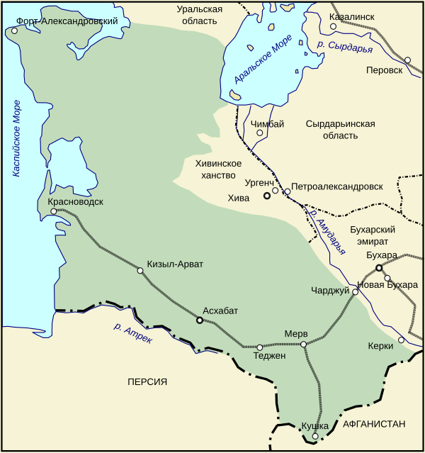
| Description | Закаспийская область в 1900 году. |
| Date | 15 December 2006 (original upload date) |
| Source | No machine-readable source provided. Own work assumed (based on copyright claims). |
| Author | No machine-readable author provided. Wassily assumed (based on copyright claims). |
Licensing
I, the copyright holder of this work, hereby publish it under the following license:

|
Permission is granted to copy, distribute and/or modify this document under the terms of the GNU Free Documentation License, Version 1.2 or any later version published by the Free Software Foundation; with no Invariant Sections, no Front-Cover Texts, and no Back-Cover Texts. A copy of the license is included in the section entitled GNU Free Documentation License. |
| This file is licensed under the Creative Commons Attribution-Share Alike 3.0 Unported license. | ||
| ||
| This licensing tag was added to this file as part of the GFDL licensing update. |
File history
Click on a date/time to view the file as it appeared at that time.
| Date/Time | Thumbnail | Dimensions | User | Comment | |
|---|---|---|---|---|---|
| current | 12:16, 30 October 2007 |
| 600 × 639 (62 KB) | WarXboT | minor fixes |
| 12:15, 30 October 2007 |
 | 277 × 292 (62 KB) | WarXboT | minor fixes | |
| 12:25, 15 December 2006 |
 | 277 × 292 (60 KB) | Wassily | ||
| 11:40, 15 December 2006 |
 | 277 × 292 (60 KB) | Wassily | Закаспийская область в 1900 году. Category:SVG карты на русском Category:Historical maps of the empire of Russia {{self|GFDL}} |
File usage
The following pages on the English Wikipedia use this file (pages on other projects are not listed):
Global file usage
The following other wikis use this file:
- Usage on fr.wikipedia.org
- Usage on ja.wikipedia.org
- Usage on ka.wikipedia.org
- Usage on kk.wikipedia.org
- Usage on ko.wikipedia.org
- Usage on nl.wikipedia.org
- Usage on pt.wikipedia.org
- Usage on ru.wikipedia.org
- Usage on tr.wikipedia.org
- Usage on uk.wikipedia.org
- Usage on uz.wikipedia.org
- Usage on vi.wikipedia.org
- Usage on www.wikidata.org
- Usage on zh.wikipedia.org
Size of this PNG preview of this SVG file:
563 × 600 pixels. Other resolutions:
225 × 240 pixels |
451 × 480 pixels |
721 × 768 pixels |
961 × 1,024 pixels |
1,923 × 2,048 pixels |
600 × 639 pixels.
Original file (SVG file, nominally 600 × 639 pixels, file size: 62 KB)
| This is a file from the
Wikimedia Commons. Information from its
description page there is shown below. Commons is a freely licensed media file repository. You can help. |
Summary
| Description | Закаспийская область в 1900 году. |
| Date | 15 December 2006 (original upload date) |
| Source | No machine-readable source provided. Own work assumed (based on copyright claims). |
| Author | No machine-readable author provided. Wassily assumed (based on copyright claims). |
Licensing
I, the copyright holder of this work, hereby publish it under the following license:
|
|
Permission is granted to copy, distribute and/or modify this document under the terms of the GNU Free Documentation License, Version 1.2 or any later version published by the Free Software Foundation; with no Invariant Sections, no Front-Cover Texts, and no Back-Cover Texts. A copy of the license is included in the section entitled GNU Free Documentation License. |
| This file is licensed under the Creative Commons Attribution-Share Alike 3.0 Unported license. | ||
| ||
| This licensing tag was added to this file as part of the GFDL licensing update. |
File history
Click on a date/time to view the file as it appeared at that time.
| Date/Time | Thumbnail | Dimensions | User | Comment | |
|---|---|---|---|---|---|
| current | 12:16, 30 October 2007 |
| 600 × 639 (62 KB) | WarXboT | minor fixes |
| 12:15, 30 October 2007 |
| 277 × 292 (62 KB) | WarXboT | minor fixes | |
| 12:25, 15 December 2006 |
| 277 × 292 (60 KB) | Wassily | ||
| 11:40, 15 December 2006 |
| 277 × 292 (60 KB) | Wassily | Закаспийская область в 1900 году. Category:SVG карты на русском Category:Historical maps of the empire of Russia {{self|GFDL}} |
File usage
The following pages on the English Wikipedia use this file (pages on other projects are not listed):
Global file usage
The following other wikis use this file:
- Usage on fr.wikipedia.org
- Usage on ja.wikipedia.org
- Usage on ka.wikipedia.org
- Usage on kk.wikipedia.org
- Usage on ko.wikipedia.org
- Usage on nl.wikipedia.org
- Usage on pt.wikipedia.org
- Usage on ru.wikipedia.org
- Usage on tr.wikipedia.org
- Usage on uk.wikipedia.org
- Usage on uz.wikipedia.org
- Usage on vi.wikipedia.org
- Usage on www.wikidata.org
- Usage on zh.wikipedia.org