Feda | |
|---|---|
Village | |
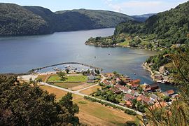
.jpg) View of the village | |
 Feda Location of the village  Feda Feda (Norway) | |
| Coordinates: 58°15′58″N 06°49′08″E / 58.26611°N 6.81889°E | |
| Country | Norway |
| Region | Southern Norway |
| County | Agder |
| District | Lister |
| Municipality | Kvinesdal |
| Area | |
| • Total | 0.49 km2 (0.19 sq mi) |
| Elevation | 7 m (23 ft) |
| Population (2015)
[1] | |
| • Total | 404 |
| • Density | 824/km2 (2,130/sq mi) |
| Time zone | UTC+01:00 ( CET) |
| • Summer ( DST) | UTC+02:00 ( CEST) |
| Post Code | 4485 Feda |
Feda is a village in Kvinesdal municipality in Agder county, Norway. The village is located on the north side of the Fedafjorden, about 10 kilometres (6.2 mi) southwest of the village of Liknes and about 12 kilometres (7.5 mi) east of the town of Flekkefjord. The 0.49-square-kilometre (120-acre) village has a population (2015) of 404, giving the village a population density of 824 inhabitants per square kilometre (2,130/sq mi). [1] [3]
The European route E39 highway passes through the village. Feda is home to the static inverter plant of HVDC NorNed. The station was built close to an existing electrical substation. Feda Church is located in the village, serving the southern part of the Kvinesdal municipality.
From 1900 to 1963 Feda was the administrative centre of Feda municipality.
Name
The municipality (originally the parish) is named after the old "Fede" farm. The name of the farm comes from the river Fedaelva which flows into the Fedafjorden near the farm. [4]
Notable people
Media gallery
-
 View of Feda from the bridge across the Fedafjorden
 -
 View of Feda
 -
 Mouth of the Fedaelva at the Fedafjorden

.jpg)

References
- ^ a b c Statistisk sentralbyrå (1 January 2015). "Urban settlements. Population and area, by municipality".
- ^ "Feda, Kvinesdal (Vest-Agder)". yr.no. Retrieved 14 September 2016.
- ^ Store norske leksikon. "Feda – tettsted" (in Norwegian). Retrieved 14 September 2016.
- ^ Rygh, Oluf (1912). Norske gaardnavne: Lister og Mandals amt (in Norwegian) (9 ed.). Kristiania, Norge: W. C. Fabritius & sønners bogtrikkeri. p. 279.
External links
- Weather information for Feda Archived 28 December 2018 at the Wayback Machine (in Norwegian)
| International | |
|---|---|
| National | |
Feda | |
|---|---|
Village | |
|
View of the village | |
Feda Location of the village Feda Feda (Norway) | |
| Coordinates: 58°15′58″N 06°49′08″E / 58.26611°N 6.81889°E | |
| Country | Norway |
| Region | Southern Norway |
| County | Agder |
| District | Lister |
| Municipality | Kvinesdal |
| Area | |
| • Total | 0.49 km2 (0.19 sq mi) |
| Elevation | 7 m (23 ft) |
| Population (2015)
[1] | |
| • Total | 404 |
| • Density | 824/km2 (2,130/sq mi) |
| Time zone | UTC+01:00 ( CET) |
| • Summer ( DST) | UTC+02:00 ( CEST) |
| Post Code | 4485 Feda |
Feda is a village in Kvinesdal municipality in Agder county, Norway. The village is located on the north side of the Fedafjorden, about 10 kilometres (6.2 mi) southwest of the village of Liknes and about 12 kilometres (7.5 mi) east of the town of Flekkefjord. The 0.49-square-kilometre (120-acre) village has a population (2015) of 404, giving the village a population density of 824 inhabitants per square kilometre (2,130/sq mi). [1] [3]
The European route E39 highway passes through the village. Feda is home to the static inverter plant of HVDC NorNed. The station was built close to an existing electrical substation. Feda Church is located in the village, serving the southern part of the Kvinesdal municipality.
From 1900 to 1963 Feda was the administrative centre of Feda municipality.
Name
The municipality (originally the parish) is named after the old "Fede" farm. The name of the farm comes from the river Fedaelva which flows into the Fedafjorden near the farm. [4]
Notable people
Media gallery
-
View of Feda from the bridge across the Fedafjorden
-
View of Feda
-
Mouth of the Fedaelva at the Fedafjorden
References
- ^ a b c Statistisk sentralbyrå (1 January 2015). "Urban settlements. Population and area, by municipality".
- ^ "Feda, Kvinesdal (Vest-Agder)". yr.no. Retrieved 14 September 2016.
- ^ Store norske leksikon. "Feda – tettsted" (in Norwegian). Retrieved 14 September 2016.
- ^ Rygh, Oluf (1912). Norske gaardnavne: Lister og Mandals amt (in Norwegian) (9 ed.). Kristiania, Norge: W. C. Fabritius & sønners bogtrikkeri. p. 279.
External links
- Weather information for Feda Archived 28 December 2018 at the Wayback Machine (in Norwegian)
| International | |
|---|---|
| National | |