Farmhaven, Mississippi | |
|---|---|
 Farmhaven  Farmhaven | |
| Coordinates: 32°38′51″N 89°48′38″W / 32.64750°N 89.81056°W | |
| Country | United States |
| State | Mississippi |
| County | Madison |
| Elevation | 374 ft (114 m) |
| Time zone | UTC-6 ( Central (CST)) |
| • Summer ( DST) | UTC-5 (CDT) |
| ZIP code | 39046 |
| Area code | 601 |
| GNIS feature ID | 669914 [1] |
Farmhaven is an unincorporated community located in Madison County, Mississippi. Farmhaven is approximately 13 miles (21 km) east of Sharon and approximately 5 miles (8.0 km) west of Carthage on Pat Luckett Road situated between Mississippi Highway 16 and the Natchez Trace Parkway.
Farmhaven is located within the Jackson Metropolitan Statistical Area.
Notable people
- Evie Dennis, United States Olympic Committee vice president from 1981 to 1988 [2]
- Flonzie Brown Wright, civil rights activist [3]
References
- ^ U.S. Geological Survey Geographic Names Information System: Farmhaven, Madison County, Mississippi
- ^ "Dr. Evie Dennis". usatf.org. Retrieved May 20, 2023.
- ^ "Flonzie Brown Wright's Biography". The HistoryMakers. December 13, 2017. Retrieved October 21, 2022.
Municipalities and communities of
Madison County, Mississippi, United States | ||
|---|---|---|
| Cities | 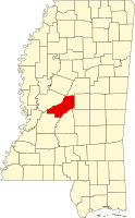 | |
| Town | ||
| CDPs | ||
|
Other communities | ||
| Ghost town | ||
| Footnotes | ‡This populated place also has portions in an adjacent county or counties | |
|
| This Madison County, Mississippi state location article is a stub. You can help Wikipedia by expanding it. |
Farmhaven, Mississippi | |
|---|---|
Farmhaven Farmhaven | |
| Coordinates: 32°38′51″N 89°48′38″W / 32.64750°N 89.81056°W | |
| Country | United States |
| State | Mississippi |
| County | Madison |
| Elevation | 374 ft (114 m) |
| Time zone | UTC-6 ( Central (CST)) |
| • Summer ( DST) | UTC-5 (CDT) |
| ZIP code | 39046 |
| Area code | 601 |
| GNIS feature ID | 669914 [1] |
Farmhaven is an unincorporated community located in Madison County, Mississippi. Farmhaven is approximately 13 miles (21 km) east of Sharon and approximately 5 miles (8.0 km) west of Carthage on Pat Luckett Road situated between Mississippi Highway 16 and the Natchez Trace Parkway.
Farmhaven is located within the Jackson Metropolitan Statistical Area.
Notable people
- Evie Dennis, United States Olympic Committee vice president from 1981 to 1988 [2]
- Flonzie Brown Wright, civil rights activist [3]
References
- ^ U.S. Geological Survey Geographic Names Information System: Farmhaven, Madison County, Mississippi
- ^ "Dr. Evie Dennis". usatf.org. Retrieved May 20, 2023.
- ^ "Flonzie Brown Wright's Biography". The HistoryMakers. December 13, 2017. Retrieved October 21, 2022.
Municipalities and communities of
Madison County, Mississippi, United States | ||
|---|---|---|
| Cities | | |
| Town | ||
| CDPs | ||
|
Other communities | ||
| Ghost town | ||
| Footnotes | ‡This populated place also has portions in an adjacent county or counties | |
|
| This Madison County, Mississippi state location article is a stub. You can help Wikipedia by expanding it. |