Photos • Location
(Redirected from
Fannystelle, Manitoba)
This article needs additional citations for
verification. (April 2021) |
Fannystelle | |
|---|---|
 Sacred Heart Of Jesus Roman Catholic Church, Fannystelle, Manitoba | |
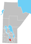
Location of Fannystelle in
Manitoba | |
| Coordinates: 49°44′41″N 97°46′40″W / 49.74472°N 97.77778°W | |
| Country | |
| Province | |
| Region | Central Plains Region |
| Census Division | No. 9 |
| Government | |
| • Governing Body | Rural Municipality of Grey Council |
| • MP | Branden Leslie |
| • MLA | Lauren Stone |
| Time zone | UTC−6 ( CST) |
| • Summer ( DST) | UTC−5 ( CDT) |
| Postal Code | R0G 0P0 |
| Area code(s) | 204, 431 |
| NTS Map | 062H12 |
| GNBC Code | GAHZY |
Fannystelle is an unincorporated settlement in southcentral Manitoba, Canada. It is situated on Provincial Trunk Highway 2 approximately 48 kilometers (30 miles) west of Winnipeg [1] in the Rural Municipality of Grey.
- ^ Government of Canada, Natural Resources Canada. "Place names - Search Results". www4.nrcan.gc.ca.
(Redirected from
Fannystelle, Manitoba)
This article needs additional citations for
verification. (April 2021) |
Fannystelle | |
|---|---|
 Sacred Heart Of Jesus Roman Catholic Church, Fannystelle, Manitoba | |
Location of Fannystelle in
Manitoba | |
| Coordinates: 49°44′41″N 97°46′40″W / 49.74472°N 97.77778°W | |
| Country | |
| Province | |
| Region | Central Plains Region |
| Census Division | No. 9 |
| Government | |
| • Governing Body | Rural Municipality of Grey Council |
| • MP | Branden Leslie |
| • MLA | Lauren Stone |
| Time zone | UTC−6 ( CST) |
| • Summer ( DST) | UTC−5 ( CDT) |
| Postal Code | R0G 0P0 |
| Area code(s) | 204, 431 |
| NTS Map | 062H12 |
| GNBC Code | GAHZY |
Fannystelle is an unincorporated settlement in southcentral Manitoba, Canada. It is situated on Provincial Trunk Highway 2 approximately 48 kilometers (30 miles) west of Winnipeg [1] in the Rural Municipality of Grey.
- ^ Government of Canada, Natural Resources Canada. "Place names - Search Results". www4.nrcan.gc.ca.

