You can help expand this article with text translated from
the corresponding article in French. (May 2010) Click [show] for important translation instructions.
|
| Falaën Castle | |
|---|---|
| Onhaye, Wallonia, Belgium | |
 | |
| Coordinates | 50°17′28″N 4°48′43″E / 50.291°N 4.812°E |
| Type | Castle |
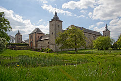
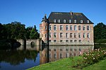
Falaën Castle is a château-ferme, or fortified farmhouse, in the village of Falaën, municipality of Onhaye, province of Namur, Wallonia, Belgium. The castle was built between 1670 and 1673 by the Polchet Family to protect themselves from traveling bands of brigands. In the 18th century it was passed to Coppin family. It was then held for another two centuries until being sold to the Delhaye Family, sometime during the 20th century. [1]
- ^ "Castles.nl - Falaën Castle". www.castles.nl. Retrieved 2023-08-26.
-
 Media related to
Château-ferme de Falaën at Wikimedia Commons
You can help expand this article with text translated from
the corresponding article in French. (May 2010) Click [show] for important translation instructions.
|
| Falaën Castle | |
|---|---|
| Onhaye, Wallonia, Belgium | |
 | |
| Coordinates | 50°17′28″N 4°48′43″E / 50.291°N 4.812°E |
| Type | Castle |
Falaën Castle is a château-ferme, or fortified farmhouse, in the village of Falaën, municipality of Onhaye, province of Namur, Wallonia, Belgium. The castle was built between 1670 and 1673 by the Polchet Family to protect themselves from traveling bands of brigands. In the 18th century it was passed to Coppin family. It was then held for another two centuries until being sold to the Delhaye Family, sometime during the 20th century. [1]
- ^ "Castles.nl - Falaën Castle". www.castles.nl. Retrieved 2023-08-26.
-
 Media related to
Château-ferme de Falaën at Wikimedia Commons


