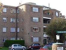
Fairacres is a Grade II listed four-storey apartment block at Roehampton Lane, Roehampton, London. [1]
It was built in 1936 by the architects Anthony Minoprio (1900–1988) and Hugh Spencely (1900–1983), for the property developer Charles Kearley. The block of 64 flats in a semi-elliptical arc is modern in style with 1930s curved walls, but traditional in construction. It is very little altered since being built. [1]
There are six acres of private gardens, overlooking the Roehampton Club grounds (and with a secure private entrance) and Richmond Park beyond. Each flat was built with 3–5 bedrooms, 2–3 bathrooms, drawing room, dining room and servant's quarters. [2]
- ^ a b Historic England. "Fairacres (1065482)". National Heritage List for England. Retrieved 3 April 2015.
- ^ "1930–1950". Fairacres.info. Retrieved 4 April 2014.