Photos • Location

Former airport.
Esperadinha Airport | |||||||||||
|---|---|---|---|---|---|---|---|---|---|---|---|
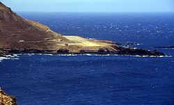
 The airport in 1994 | |||||||||||
| Summary | |||||||||||
| Airport type | Public | ||||||||||
| Serves | Brava island | ||||||||||
| Location | |||||||||||
| Opened | 1992 | ||||||||||
| Closed | 2004 | ||||||||||
| Elevation AMSL | 64 ft / 20 m | ||||||||||
| Coordinates | 14°51′51.6″N 24°44′45.5″W / 14.864333°N 24.745972°W | ||||||||||
| Map | |||||||||||
| Runways | |||||||||||
| |||||||||||
Esperadinha Airport ( IATA: BVR, ICAO: GVBR) was a public use airport located near the hamlet of Esperadinha, northwestern Brava, Cape Verde. It opened in 1992 and operated until 2004, when it was closed due to persistent dangerous high winds.

See also
References
- ^ Airport record for Esperadinha Airport at Landings.com. Retrieved 2013-08-25
- ^ Google (2013-08-25). "location of Esperadinha Airport" (Map). Google Maps. Google. Retrieved 2013-08-25.
External links
- Airport record for Esperadinha Airport Archived 2015-04-02 at the Wayback Machine at Landings.com
Esperadinha Airport | |||||||||||
|---|---|---|---|---|---|---|---|---|---|---|---|
 The airport in 1994 | |||||||||||
| Summary | |||||||||||
| Airport type | Public | ||||||||||
| Serves | Brava island | ||||||||||
| Location | |||||||||||
| Opened | 1992 | ||||||||||
| Closed | 2004 | ||||||||||
| Elevation AMSL | 64 ft / 20 m | ||||||||||
| Coordinates | 14°51′51.6″N 24°44′45.5″W / 14.864333°N 24.745972°W | ||||||||||
| Map | |||||||||||
| Runways | |||||||||||
| |||||||||||
Esperadinha Airport ( IATA: BVR, ICAO: GVBR) was a public use airport located near the hamlet of Esperadinha, northwestern Brava, Cape Verde. It opened in 1992 and operated until 2004, when it was closed due to persistent dangerous high winds.

See also
References
- ^ Airport record for Esperadinha Airport at Landings.com. Retrieved 2013-08-25
- ^ Google (2013-08-25). "location of Esperadinha Airport" (Map). Google Maps. Google. Retrieved 2013-08-25.
External links
- Airport record for Esperadinha Airport Archived 2015-04-02 at the Wayback Machine at Landings.com

