 Elikalpeni Bank | |
| Geography | |
|---|---|
| Location | Arabian Sea |
| Coordinates | 11°12′N 73°58′E / 11.20°N 73.96°E |
| Type | Submerged bank |
| Archipelago | Lakshadweep |
| Adjacent to | Indian Ocean |
| Total islands | 0 |
| Area | 0 km2 (0 sq mi) [1] |
| Highest elevation | −10.4 m (-34.1 ft) |
| Administration | |
| Territory | Union territory of Lakshadweep |
| District | Lakshadweep |
| Island group | Aminidivi |
| Tehsils of India | Aminidivi |
| Subdivisions of India | Amini Island |
| Demographics | |
| Population | 0 (2014) |
| Pop. density | 0/km2 (0/sq mi) |
| Ethnic groups | Malayali, Mahls |
| Additional information | |
| Time zone | |
| ISO code | IN-LD-00 [2] |
| Official website |
www |
| Avg. summer temperature | 32.0 °C (89.6 °F) |
| Avg. winter temperature | 28.0 °C (82.4 °F) |
Elikalpeni Bank is a submerged bank or sunken atoll belonging to the Amindivi Subgroup of islands of the Union Territory of Lakshadweep, India. [3]
Geography
Elikalpeni Bank has a minimum depth of 10.4 m and is located 57 km northeast of Androth [4] at 11°12′N 73°58′E / 11.200°N 73.967°E. [5]
Elikalpeni Bank is the easternmost geographic feature of the Lakshadweep Archipelago, although other little researched banks with depths of as little as 18.3 m lie about 32 km east of Elikalpeni. [4] It has a lagoon area of 95.91 km2 (37.03 sq mi).
Image gallery
-
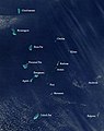 Satellite picture showing the atolls of the Lakshadweep except for Minicoy
 -
 Map
Map


References
- ^ "Islandwise Area and Population - 2011 Census" (PDF). Government of Lakshadweep. Archived from the original (PDF) on 22 July 2016.
- ^ Registration Plate Numbers added to ISO Code
- ^ Hydrographic Description (Indian Ocean Pilot)
- ^ a b Prostar Sailing Directions 2005 India & Bay of Bengal Enroute, National Geospatial-intelligence Agency
- ^ GEBCO Gazeteer of undersea feature names
External links
- Elikalpeni Bank, India
- List of Atolls Archived 13 August 2012 at the Wayback Machine
- Sources towards a history of the Laccadive Islands
|
| This article related to a location in the Indian union territory of Lakshadweep Islands is a stub. You can help Wikipedia by expanding it. |
Elikalpeni Bank | |
| Geography | |
|---|---|
| Location | Arabian Sea |
| Coordinates | 11°12′N 73°58′E / 11.20°N 73.96°E |
| Type | Submerged bank |
| Archipelago | Lakshadweep |
| Adjacent to | Indian Ocean |
| Total islands | 0 |
| Area | 0 km2 (0 sq mi) [1] |
| Highest elevation | −10.4 m (-34.1 ft) |
| Administration | |
| Territory | Union territory of Lakshadweep |
| District | Lakshadweep |
| Island group | Aminidivi |
| Tehsils of India | Aminidivi |
| Subdivisions of India | Amini Island |
| Demographics | |
| Population | 0 (2014) |
| Pop. density | 0/km2 (0/sq mi) |
| Ethnic groups | Malayali, Mahls |
| Additional information | |
| Time zone | |
| ISO code | IN-LD-00 [2] |
| Official website |
www |
| Avg. summer temperature | 32.0 °C (89.6 °F) |
| Avg. winter temperature | 28.0 °C (82.4 °F) |
Elikalpeni Bank is a submerged bank or sunken atoll belonging to the Amindivi Subgroup of islands of the Union Territory of Lakshadweep, India. [3]
Geography
Elikalpeni Bank has a minimum depth of 10.4 m and is located 57 km northeast of Androth [4] at 11°12′N 73°58′E / 11.200°N 73.967°E. [5]
Elikalpeni Bank is the easternmost geographic feature of the Lakshadweep Archipelago, although other little researched banks with depths of as little as 18.3 m lie about 32 km east of Elikalpeni. [4] It has a lagoon area of 95.91 km2 (37.03 sq mi).
Image gallery
-
Satellite picture showing the atolls of the Lakshadweep except for Minicoy
-
Map
References
- ^ "Islandwise Area and Population - 2011 Census" (PDF). Government of Lakshadweep. Archived from the original (PDF) on 22 July 2016.
- ^ Registration Plate Numbers added to ISO Code
- ^ Hydrographic Description (Indian Ocean Pilot)
- ^ a b Prostar Sailing Directions 2005 India & Bay of Bengal Enroute, National Geospatial-intelligence Agency
- ^ GEBCO Gazeteer of undersea feature names
External links
- Elikalpeni Bank, India
- List of Atolls Archived 13 August 2012 at the Wayback Machine
- Sources towards a history of the Laccadive Islands
|
| This article related to a location in the Indian union territory of Lakshadweep Islands is a stub. You can help Wikipedia by expanding it. |