Photos • Location
El Mechira
المشيرة | |
|---|---|
Commune and town | |
 | |
| Country | |
| Province | Mila Province |
| Area | |
| • Total | 74.22 sq mi (192.22 km2) |
| Population (2008) | |
| • Total | 12,908 |
| Time zone | UTC+1 ( CET) |
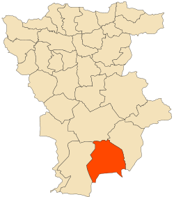
El Mechira is a town and commune in Mila Province, Algeria. At the 1998 census it had a population of 11,683. [1]
36°00′37″N 6°13′53″E / 36.010247°N 6.231267°E
El Mechira
المشيرة | |
|---|---|
Commune and town | |
 | |
| Country | |
| Province | Mila Province |
| Area | |
| • Total | 74.22 sq mi (192.22 km2) |
| Population (2008) | |
| • Total | 12,908 |
| Time zone | UTC+1 ( CET) |
El Mechira is a town and commune in Mila Province, Algeria. At the 1998 census it had a population of 11,683. [1]
36°00′37″N 6°13′53″E / 36.010247°N 6.231267°E
