Eger District
Egri járás | |
|---|---|
 Coat of arms | |
 Eger District within Hungary and Heves County. | |
| Country | |
| County | Heves |
| District seat | Eger |
| Area | |
| • Total | 602.05 km2 (232.45 sq mi) |
| • Rank | 3rd in Heves |
| Population (2011 census) | |
| • Total | 87,939 |
| • Rank | 1st in Heves |
| • Density | 146/km2 (380/sq mi) |
Eger ( Hungarian: Egri járás) is a district in eastern part of Heves County. Eger is also the name of the town where the district seat is found. The district is located in the Northern Hungary Statistical Region. This district lies between of Bükk Mountains and Mátra Mountains geographical region.
Geography
Eger District borders with Bélapátfalva District to the north, Mezőkövesd District ( Borsod-Abaúj-Zemplén County) to the east, Füzesabony District to the south, Gyöngyös District and Pétervására District to the west. The number of the inhabited places in Eger District is 22.
Municipalities
The district has 1 urban county, 1 town and 20 villages. (ordered by population, as of 1 January 2012) [1]
- Andornaktálya (2,740)
- Bátor (407)
- Demjén (590)
- Eger (56,166) – district and county seat
- Egerbakta (1,434)
- Egerbocs (531)
- Egercsehi (1,377)
- Egerszalók (1,886)
- Egerszólát (1,062)
- Feldebrő (1,021)
- Felsőtárkány (3,358)
- Hevesaranyos (582)
- Kerecsend (2,304)
- Maklár (2,398)
- Nagytálya (844)
- Noszvaj (1,857)
- Novaj (1,390)
- Ostoros (2,670)
- Szarvaskő (385)
- Szúcs (401)
- Tarnaszentmária (225)
- Verpelét (3,812)
The bolded municipalities are cities.
Demographics
Religion in Eger District (2011 census)
In 2011, it had a population of 87,939 and the population density was 146/km2.
| Year | County population [2] | Change |
|---|---|---|
| 2011 | 87,939 | n/a |
Ethnicity
Besides the Hungarian majority, the main minorities are the Roma (approx. 4,000), German (600), Romanian (150) and Slovak (100).
Total population (2011 census): 87,939
Ethnic groups (2011 census):
[3] Identified themselves: 80,504 persons:
- Hungarians: 74,703 (92.79%)
- Gypsies: 3,712 (4.61%)
- Others and indefinable: 2,089 (2.59%)
Approx. 7,500 persons in Eger District did not declare their ethnic group at the 2011 census.
Religion
Religious adherence in the county according to 2011 census: [4]
- Catholic – 40,397 ( Roman Catholic – 39,948; Greek Catholic – 441);
- Reformed – 5,241;
- Evangelical – 281;
- other religions – 1,501;
- Non-religious – 13,897;
- Atheism – 1,465;
- Undeclared – 25,157.
Gallery
-
 Eger, the Hungarian Athens
 -
 Earthwork of Verpelét
 -

-
 Spa in Egerszalók
 -

-
 Szépasszony Valley in Eger
 -
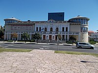 Géza Gárdonyi Theater (Eger)
 -
 Roman Catholic Church in Feldebrő
.jpg)


_2.jpg)


_(5655._sz%C3%A1m%C3%BA_m%C5%B1eml%C3%A9k)_2.jpg)
See also
References
- ^ A KSH 2012. évi helységnévkönyve
- ^ népesség.com, "Egri járás népessége"
- ^ 4.1.6.1 A népesség nemzetiség szerint, 2011, (in Hungarian) [1]
- ^ 4.1.7.1 A népesség vallás, felekezet szerint, 2011, (in Hungarian) [2]
External links
| City with county rights (1) |
| |
|---|---|---|
| Town (1) | ||
| Villages (20) | ||
47°54′00″N 20°22′00″E / 47.9000°N 20.3667°E
|
| This Heves county location article is a stub. You can help Wikipedia by expanding it. |
Eger District
Egri járás | |
|---|---|
|
Coat of arms | |
|
Eger District within Hungary and Heves County. | |
| Country | |
| County | Heves |
| District seat | Eger |
| Area | |
| • Total | 602.05 km2 (232.45 sq mi) |
| • Rank | 3rd in Heves |
| Population (2011 census) | |
| • Total | 87,939 |
| • Rank | 1st in Heves |
| • Density | 146/km2 (380/sq mi) |
Eger ( Hungarian: Egri járás) is a district in eastern part of Heves County. Eger is also the name of the town where the district seat is found. The district is located in the Northern Hungary Statistical Region. This district lies between of Bükk Mountains and Mátra Mountains geographical region.
Geography
Eger District borders with Bélapátfalva District to the north, Mezőkövesd District ( Borsod-Abaúj-Zemplén County) to the east, Füzesabony District to the south, Gyöngyös District and Pétervására District to the west. The number of the inhabited places in Eger District is 22.
Municipalities
The district has 1 urban county, 1 town and 20 villages. (ordered by population, as of 1 January 2012) [1]
- Andornaktálya (2,740)
- Bátor (407)
- Demjén (590)
- Eger (56,166) – district and county seat
- Egerbakta (1,434)
- Egerbocs (531)
- Egercsehi (1,377)
- Egerszalók (1,886)
- Egerszólát (1,062)
- Feldebrő (1,021)
- Felsőtárkány (3,358)
- Hevesaranyos (582)
- Kerecsend (2,304)
- Maklár (2,398)
- Nagytálya (844)
- Noszvaj (1,857)
- Novaj (1,390)
- Ostoros (2,670)
- Szarvaskő (385)
- Szúcs (401)
- Tarnaszentmária (225)
- Verpelét (3,812)
The bolded municipalities are cities.
Demographics
Religion in Eger District (2011 census)
In 2011, it had a population of 87,939 and the population density was 146/km2.
| Year | County population [2] | Change |
|---|---|---|
| 2011 | 87,939 | n/a |
Ethnicity
Besides the Hungarian majority, the main minorities are the Roma (approx. 4,000), German (600), Romanian (150) and Slovak (100).
Total population (2011 census): 87,939
Ethnic groups (2011 census):
[3] Identified themselves: 80,504 persons:
- Hungarians: 74,703 (92.79%)
- Gypsies: 3,712 (4.61%)
- Others and indefinable: 2,089 (2.59%)
Approx. 7,500 persons in Eger District did not declare their ethnic group at the 2011 census.
Religion
Religious adherence in the county according to 2011 census: [4]
- Catholic – 40,397 ( Roman Catholic – 39,948; Greek Catholic – 441);
- Reformed – 5,241;
- Evangelical – 281;
- other religions – 1,501;
- Non-religious – 13,897;
- Atheism – 1,465;
- Undeclared – 25,157.
Gallery
-
Eger, the Hungarian Athens
-
Earthwork of Verpelét
-
-
Spa in Egerszalók
-
-
Szépasszony Valley in Eger
-
Géza Gárdonyi Theater (Eger)
-
Roman Catholic Church in Feldebrő
See also
References
- ^ A KSH 2012. évi helységnévkönyve
- ^ népesség.com, "Egri járás népessége"
- ^ 4.1.6.1 A népesség nemzetiség szerint, 2011, (in Hungarian) [1]
- ^ 4.1.7.1 A népesség vallás, felekezet szerint, 2011, (in Hungarian) [2]
External links
| City with county rights (1) |
| |
|---|---|---|
| Town (1) | ||
| Villages (20) | ||
47°54′00″N 20°22′00″E / 47.9000°N 20.3667°E
|
| This Heves county location article is a stub. You can help Wikipedia by expanding it. |