This article needs additional citations for
verification. (August 2019) |
Edavanna | |
|---|---|
Town | |
 Edavanna Town | |
| Coordinates: 11°12′55″N 76°08′29″E / 11.2154°N 76.1413°E | |
| Country | |
| State | Kerala |
| District | Malappuram |
| Area | |
| • Total | 49.13 km2 (18.97 sq mi) |
| Languages | |
| • Official | Malayalam, English |
| Time zone | UTC+5:30 ( IST) |
| PIN | 676541 |
| Telephone code | 0483 |
| Vehicle registration | KL-10 |
| Website | http://lsgkerala.in/edavannapanchayat |
Edavanna is a town situated in Eranad Taluk of Malappuram District, Kerala, South India. The town is situated on Calicut– Nilambur– Gudalur state highway and near the banks of the Chaliyar River. The Koyilandy-Edavanna state highway ends here. Edavanna is part of the Eranad Assembly constituency and Wayanad Lok Sabha constituency.
References
External links
![]() Media related to
Edavanna at Wikimedia Commons
Media related to
Edavanna at Wikimedia Commons
This article needs additional citations for
verification. (August 2019) |
Edavanna | |
|---|---|
Town | |
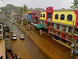
 Edavanna Town | |
| Coordinates: 11°12′55″N 76°08′29″E / 11.2154°N 76.1413°E | |
| Country | |
| State | Kerala |
| District | Malappuram |
| Area | |
| • Total | 49.13 km2 (18.97 sq mi) |
| Languages | |
| • Official | Malayalam, English |
| Time zone | UTC+5:30 ( IST) |
| PIN | 676541 |
| Telephone code | 0483 |
| Vehicle registration | KL-10 |
| Website | http://lsgkerala.in/edavannapanchayat |
Edavanna is a town situated in Eranad Taluk of Malappuram District, Kerala, South India. The town is situated on Calicut– Nilambur– Gudalur state highway and near the banks of the Chaliyar River. The Koyilandy-Edavanna state highway ends here. Edavanna is part of the Eranad Assembly constituency and Wayanad Lok Sabha constituency.
References
External links
![]() Media related to
Edavanna at Wikimedia Commons
Media related to
Edavanna at Wikimedia Commons