Photos • Location
From Wikipedia, the free encyclopedia
Municipality in the state of São Paulo in Brazil
For the Brazilian footballer, see
Echaporã (footballer).
Municipality in Southeast, Brazil
Echaporã | |
|---|---|
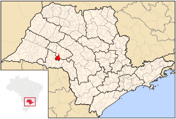
 Location in São Paulo state | |
| Coordinates: 22°25′46″S 50°12′2″W / 22.42944°S 50.20056°W / -22.42944; -50.20056 | |
| Country | Brazil |
| Region | Southeast |
| State | São Paulo |
| Area | |
| • Total | 516 km2 (199 sq mi) |
| Population (2020
[1]) | |
| • Total | 6,064 |
| • Density | 12/km2 (30/sq mi) |
| Time zone | UTC−3 ( BRT) |
Echaporã is a municipality in the state of São Paulo in Brazil. The population is 6,064 (2020 est.) in an area of 516 km². [2] The elevation is 700 m.
Notable people
- Roberta Murgo (born 1987), Brazilian model
References
Capital:
São Paulo | |||||||||||||||||||||
| |||||||||||||||||||||
| |||||||||||||||||||||
| |||||||||||||||||||||
| |||||||||||||||||||||
| |||||||||||||||||||||
| |||||||||||||||||||||
| |||||||||||||||||||||
| |||||||||||||||||||||
| |||||||||||||||||||||
| |||||||||||||||||||||
| |||||||||||||||||||||
| |||||||||||||||||||||
| |||||||||||||||||||||
| |||||||||||||||||||||
Retrieved from "
https://en.wikipedia.org/?title=Echaporã&oldid=1133825264"
From Wikipedia, the free encyclopedia
Municipality in the state of São Paulo in Brazil
For the Brazilian footballer, see
Echaporã (footballer).
Municipality in Southeast, Brazil
Echaporã | |
|---|---|
 Location in São Paulo state | |
| Coordinates: 22°25′46″S 50°12′2″W / 22.42944°S 50.20056°W / -22.42944; -50.20056 | |
| Country | Brazil |
| Region | Southeast |
| State | São Paulo |
| Area | |
| • Total | 516 km2 (199 sq mi) |
| Population (2020
[1]) | |
| • Total | 6,064 |
| • Density | 12/km2 (30/sq mi) |
| Time zone | UTC−3 ( BRT) |
Echaporã is a municipality in the state of São Paulo in Brazil. The population is 6,064 (2020 est.) in an area of 516 km². [2] The elevation is 700 m.
Notable people
- Roberta Murgo (born 1987), Brazilian model
References
Capital:
São Paulo | |||||||||||||||||||||
| |||||||||||||||||||||
| |||||||||||||||||||||
| |||||||||||||||||||||
| |||||||||||||||||||||
| |||||||||||||||||||||
| |||||||||||||||||||||
| |||||||||||||||||||||
| |||||||||||||||||||||
| |||||||||||||||||||||
| |||||||||||||||||||||
| |||||||||||||||||||||
| |||||||||||||||||||||
| |||||||||||||||||||||
| |||||||||||||||||||||
| |||||||||||||||||||||
Retrieved from "
https://en.wikipedia.org/?title=Echaporã&oldid=1133825264"


