You can help expand this article with text translated from
the corresponding article in German. (February 2024) Click [show] for important translation instructions.
|
| East TimorŌĆōIndonesia border | |
|---|---|
 Map of the East TimorŌĆōIndonesia border | |
| Characteristics | |
| Entities | |
| Length | 253 km (157 mi) |
| Enclave and exclaves | Oecusse |
| History | |
| Established | 25 June 1914 Court of Arbitration's award |
| Current shape | 2002 East Timor independence |
| Treaties |
Treaty of Lisbon of 1859 1999 East Timorese independence referendum |
The East TimorŌĆōIndonesia border is the international border between East Timor and Indonesia. The border consists of two non-contiguous sections totalling 253 km (157 m) in length, the larger section of which divides the island of Timor in two. [1] The demarcation of the border between Indonesia and East Timor has been fought over by various parties for 350 years. The first attempts to define it precisely were made by the colonial powers of the Netherlands and Portugal with the Treaty of Lisbon in 1859, but it was not until the Permanent Court of Arbitration's award of 25 June 1914 that the final land border between them on the island of Timor was established. It largely coincides with today's border between the state of East Timor (Timor-Leste), which only gained its final independence in 2002, and West Timor, which belongs to Indonesia, but was still disputed on some points until 2019. [2]
Description

Western (Oecusse) section
The Municipality of Oecusse forms an exclave of East Timor in Indonesian West Timor (part of East Nusa Tenggara province). The border starts in the west at the coast of the Savu Sea, proceeding overland to the south to the Noel Besi River, which it then follows south, then east, then south. The border then turns east overland briefly, before turning to the north, utilising various rivers such as the Ekan, Sonau and Bilomi, before proceeding northwards overland to the Savu coast.
Eastern section
The border between Indonesia and the main part of East Timor starts in the north at the Savu Sea coast, and proceeds south and then east via the Talu river. It then turns south along the Malibacu river, and then west along the Tafara river, then south along the Massin river down to the coast at the Timor Sea.
History
Colonization
The division of the island of Timor dates to the colonial period. During the 15thŌĆō16th centuries both the Netherlands and Portugal began taking an interest in the Spice Islands of modern Indonesia. [3] The Portuguese first landed on Timor in 1512 and established their first settlement in Lifau in western Timor in 1556. The Dutch followed shortly after, but did not establish themselves in the west of the island until 1640[ citation needed] when the Dutch started to occupy the western half of the island as part of its Dutch East Indies colony. [3] In 1642, the Portuguese conquered the island's spiritual centre at Wehale, after which most Timorese rulers ( Liurai) recognised Portugal's dominance. Thus,[ citation needed] Portugal started to occupy the eastern half of Timor and declared the creation of Portuguese Timor. [4] [5] In 1656, the Dutch conquered the Portuguese base at Kupang. In 1749, an attempted reconquest by the Portuguese failed at the Battle of Penfui, whereupon most rulers in the west signed treaties with the Dutch East India Company. Among them was a certain Jacinto Correa, King of Wewiku-Wehale and Grand Prince of Belu, who also signed the dubious Treaty of Paravicini on behalf of many territories in central Timor. Fortunately for the Portuguese, Wehale was no longer powerful enough to draw the local rulers to the side of the Dutch. Thus the eastern former vassals of Wehale remained under the flag of Portugal, while Wehale itself fell under Dutch rule. The result was a permanent dispute over the boundaries of the spheres of influence of the colonial powers. [5]
Negotiations between the colonial powers in the 19th century

In 1851, the Portuguese governor Jos├® Joaquim Lopes de Lima reached an agreement with the Dutch on the division of the colonies in the Lesser Sunda Islands. However, this was not authorised by Lisbon, which is why the agreements were only confirmed in the Treaty of Lisbon in 1859 after new negotiations from 1854. On 20 April 1859 a treaty was signed (ratified 1860) which formally divided the island between the Netherlands and Portugal, with a border based on existing Timorese states which were assigned to either Portugal or the Netherlands. [3] [6] However, the exact course of the border was still unclear, and with Portuguese Noimuti and Dutch Maucatar, there was also one enclave each of the colonial power without access to the sea on the side of the competitor.
On 10 June 1893, An additional treaty, the Lisbon Convention, was then signed between the governments, with the intention of creating favourable conditions "for the development of civilisation and trade" and for the dissolution of the still existing enclaves (ratified 1894). A commission of experts was to be convened for the new demarcation of borders. If difficulties arose, a mediator was to be called in. The commission visited Timor and came to an agreement on most of the border between 1898 and 1899. The problem with the enclaves of Noimuti and Maucatar remained unresolved. The original reason of the Dutch for this round of negotiations was the desire for a right of first refusal for East Timor. [3] There were rumours that Russia and Germany wanted to establish a coal station in Portuguese Timor, respectively that the colony would be exchanged for the recognition of Portuguese claims in Africa with Germany, France or England. [7] In fact, on 30 August 1898, Germany and Britain agreed in the Angola Treaty on a joint bond for the heavily indebted Portugal, for which the Portuguese colonies were intended as a pledge. In the event of insolvency, Portuguese Timor would have fallen to Germany. As early as 1899, however, the treaty was undermined by the extension of the British guarantee of protection for Portugal and all its possessions. [3]
In 1897, fighting broke out over Lamaknen between Lamaquitos, which was under Portuguese sovereignty, and Dutch-dominated Lakmaras. [8] In Lakmaras itself, skirmishes between the two colonial forces resulted in casualties. [9] Between 23 June and 3 July 1902, there was another conference in The Hague. [3] It was argued whether Oe-Cusse Ambeno was part of the Lisbon Convention on the exchange of enclaves or not. Portugal objected, saying that the area had a coastal course and therefore did not fall under the definition of an enclave. [10] The Dutch claim to Maucatar had previously been based on their suzerainty over Lakmaras, which created a link to Maucatar. In the meantime, however, Lakmaras had become a subject of the Empire of Lamaquitos in the Portuguese sphere of power and Maucatar would have to fall to Portugal as an enclave according to the previous agreements. [7] [9] [11] On the other hand, the Tahakay Empire (Tahakai, Tafakay, Takay) had in the meantime fallen to the Lamaknen Empire. Tahakay, however, belonged to the Portuguese sphere of influence, Lamaknen to the Dutch. Portugal resisted this loss in the negotiations and therefore now demanded the entire Dutch territories in central Timor. [9] A compromise was reached with the Hague Convention of 1 October 1904. Portugal was to receive the Dutch enclave of Maucatar in exchange for the Portuguese enclave of Noimuti and the border areas of Tahakay, Tamira Ailala (Tamiru Ailala) and Lamaknen. The disputed territories in the east of Oe-Cusse Ambeno were granted to the Dutch. The border was defined from the confluence of the No├©l Bilomi and O├© Sunan, following the Thalweg path of the O├© Sunan, continuing through Nipani and Kelali (Keli) to the source of the No├©l Meto, and following its valley path to its mouth. In addition, the Dutch now secured the right of first refusal for East Timor. Portugal ratified the treaty until 1909, but then a dispute arose over the demarcation of the eastern border of Oe-Cusse Ambeno. [12] In 1910, the Netherlands took advantage of the confused situation after the fall of the Portuguese monarchy to seize Lakmaras again with European and Javanese troops. [13]
Problems with surveying

Between 1 and 10 June 1909, a commission carried out a survey of the eastern boundary of Oecussi-Ambeno, but could not agree on the correct course and decided to transfer the open questions back to their governments. [7]
The commission had started surveying in the north on the coast and followed the course of the No├©l Meto southwards. Its source served as a measuring point. However, the way to the source was blocked by steep cliffs that could not be overcome, so the surveyors decided to survey only the areas to the north and south. Thus, an area between the source of the No├©l Meto in the north and the course of the No├©l Bilomi in the south was missing. Discrepancies arose first in the north. On the 1904 map (Annex III), the name Kelali was found with Keli in brackets. The Dutch assigned this mark to the summit of Mount Kelali. This lies to the west of the No├©l Meto between two pointed rocks and was given by the inhabitants of the Dutch Tumbaba as the border to the Portuguese Ambeno. Instead, the Portuguese asked to follow the valley paths east of it. [7]
In the southern part, the commission investigated the demarcation along the course of the Nono Nisi (Nise) on 17 June 1909, then further along the course of the No├©l Bilomi, finally arriving at the point where the 1899 expedition had finished its work. The point was marked on the 1904 map as the confluence of the No├©l Bilomi and the O├© Sunan. The present commission found two northern tributaries here, but neither of them had the name O├© Sunan. The Dutch explained this by saying that the area between the tributaries was called Sunan and that there was actually no tributary named O├© Sunan, although the confluence was the starting point of the boundary demarcation on the 1899 and 1904 maps. The Portuguese noted that there was a river further east called O├© Sunan or Oil Sunan, which was not a tributary of the No├©l Bilomi, but whose source was in the "very close to the No├©l Bilomi". Finally, the commission agreed that there is no tributary called O├© Sunan on the No├©l Bilomi, but that the river changes its name. The Portuguese stressed that this meant that the No├©l Bilomi still existed. [7]
The Dutch delegation explained that the Bilomi had changed names in this region. "Yes, the river exists," the Portuguese replied, "but, according to indigenous tradition, it bears the name of the area it is crossing". Finally, the Portuguese delegation added, not very far from the north bank of the Bilomis stands Mount Kinapua. On its opposite slope, the O├© Sunan flows towards the north. It was only necessary to follow this river course, then up the Noi Fulan river to its source and finally connect it with the source of the No├©l Meto, which had already been recognised by the joint commission. [7]
However, the Dutch felt that there was no point in pursuing the survey of this river, as both Mount Kinapua and the border area that would be created under the Portuguese proposal were outside the territory contested in 1899. Mount Tasonal appears on the 1899 map on the farthest eastern boundary of the then Portuguese claims, which were rejected by the 1904 Agreement. In this respect, a border area going even further east is out of the question. There were numerous areas of the boundary which the two sides were unable to come to agreement on, prompting a further conference held at The Hague in 1902. A treaty was subsequently signed on 1 October 1904 (ratified 1908) which created the modern boundary, removing a number of enclaves whilst leaving the exclave of Oecusse as part of Portuguese Timor. [3]
However, whilst demarcating the boundary on the ground in 1909, the two sides were unable to agree to the alignment of the eastern section of the Oecusse boundary. [3] The Joint Commission interrupted its work here and the question, meanwhile taken over by the diplomatic services, caused endless correspondence between the cabinets in The Hague and Lisbon. Out of this correspondence came the 1913 Convention, which gave an arbitrator the right to decide, according to the "facts supplied by the two parties" and "on the basis of general fundamental rights, how the boundary from the No├©l Bilomi to the source of the No├©l Metos, in accordance with Article 3, Number 10 of the Den Hagen Agreement of 1 October 1904... should run." [7]
As the governments could not agree, it was decided to refer the matter Permanent Court of Arbitration in 1913. [3]
Court of Arbitration in The Hague
The Portuguese point of view

The Portuguese government made the following points: [7]
- The tributary to the No├©l Bilomi called O├© Sunan, which was at the point where the work was stopped in 1899, or which is indicated in the contract and map of 1904, does not exist.
- Instead, further east there is a river called O├© Sunan, which is not a tributary of the No├©l Bilomi, but has its source near its north loop at Mount Kinapua. The mountain and the O├© Sunan are considered by many local rulers to be the border point between the Portuguese Ambeno and the Dutch territories of Tumbaba and Amakono. A stream flows from Kinapua towards No├©l Bilomi, so the peak can serve as a link between the two watercourses.
- according to the indigenous rulers, the Ambeno border runs east along the O├© Sunan and north along the Ni Fullan river. To the west of the Kelali and Netton mountains lies Oecussi, which indisputably belongs to Portugal. A map by a private citizen published in Batavia even refers to the entire area claimed by the Netherlands as Ambeno.
- The treaty of 1859 is based on the principle that the native kingdoms should not be divided. Ambeno, however, will be divided with the Dutch proposed border demarcation and the inhabitants will be deprived of their pastures and fields which would then be in Dutch territory.
- there is no evidence that the boundary to be demarcated should necessarily start at the point where the demarcation work was suspended in 1899 due to hostilities between the natives and where the maps show the confluence of the Bilomi and O├© Sunan rivers, but which is not at that location. There are two streams at this place, the Kamboun and the Nono-Offi. Why follow the course of the Kamboun to the north instead of the Nono-Offi, which comes from the northeast and joins the Bilomi at this point?
- In the view of the Portuguese government, it was only desirable to give the Boundary Commissioners a sketch, using the 1899 and 1904 maps, for the purpose of fixing ideas, and as a vague and simple indication of what was to be settled later.
- The real intention of the signatories to the 1904 Treaty was to follow the course of the O├© Sunan where it actually lies, that is, much further east. In terms of the treaty, therefore, nothing prevents the Bilomi from rising to the point closest to the source of the true O├© Sunan, a source so close to the course of the Bilomi that it is almost a tributary.
- the line proposed by the Netherlands to "cross as far as possible Nipani and Kelali (Keli)" according to the 1904 treaty does not cross Nipani but only touches the Fatu Nipani, i.e. the western end of the Nipani. Therefore, it does not correspond to the 1904 plan.
- the line proposed by the Netherlands is not a natural boundary, while the line proposed by Portugal follows watercourses for almost its entire length.
The Dutch point of view


The main arguments of the government of the Netherlands can be summarized as follows: [7]
- The 1859 Treaty does not mandate that native territories should not be partitioned or parceled out. On the contrary, it assigned to Portugal the state of Ambeno "wherever the Portuguese flag is set there", but does not thereby prohibit the partition of an indigenous state, but calls for the partition of the state of Ambeno precisely by saying: "The Netherlands cede to Portugal ... that part of the state of Ambenu or Ambeno which for several years has flown the Portuguese flag."
- There is no uncertainty as to the place where the border commissioners ceased in 1899. This point served as the basis for the 1902 negotiations and was marked on the map (Annex III) signed by the negotiating parties at that time to be attached to the draft treaty. This 1902 draft became the 1904 Treaty. From this point, and from no other point, begins the line AC, which was recognised in 1902 as a duly constituted boundary (Map Annex I). This line AC extends northwards from this point to the source of the river No├©l Meto, and the boundary was then to follow this watercourse to its mouth in the sea to the north.
- The location of the source of the No├©l Meto was recognised differently in 1909: A marker was placed there by mutual agreement. The discussion concerned only the elevation between this source and point A, which was at the place where the commissioners stopped in 1899.
- On the official map of 1899 (Appendix IV), as on the official map of 1904 (Appendix III), a tributary to which the name O├© Sunan was given by a mistake which the Netherlands do not dispute, is shown as coming from the north to the point in question. This tributary, which in reality bears the name of Kabun among the Tumbabas and that of L├©os among the Ambenos, is entirely in accordance with the intention of the contracting parties, which was that a tributary coming from the north should take the direction of AC from point A. The mistake in the name has less significance, since the watercourses in this region very often have several names or change their names or bear the name of the country they cross: the region east of the Kabun or L├©os (the O├© Sunan of 1904) has the name Hue Son, according to the Portuguese government, a similar sound, and the name Sunan according to the Dutch commissioners, which could explain the mistake of the commissioners.
- The native rulers of Amakono (Dutch) declared (Joint Commission meeting of 21 February 1899) that their land comprised the entire region lying between O├© Sunan, Nipani, Kelali-Keli and No├©l Meto (to the west), the Sea of Timor (to the north), the No├©l Boll Bass, the Humusu and Kin Napua mountains (to the east), Tasona, the No├©l Boho and the No├©l Bilomi (to the south). The western boundary described in 1899 between the Dutch Amakono and the Portuguese Ambeno is that established by the 1904 Treaty. The O├© Sunan that appears there can only be the watercourse that was mistakenly entered in the official maps of 1899 and 1904 by mutual agreement, i.e. a watercourse to the west of the disputed territory and not the alleged O├© Sunan to which Portugal now refers and which lies on the eastern border of the disputed territory. The 1904 Treaty assigned this disputed territory to the Netherlands. The border is therefore supposed to be on the watercourse to the west, whatever it is called.
- The proof that Portugal in 1899 and 1904 could not have taken into account the eastern stream, to which it now gives the name of O├© Sunan, is the fact that its Commissioners in the meeting of 21. February 1899 proposed as a boundary a line beginning at the point where the stream now called O├© Sunan joins the Bilomi, and then following the No├©l Bilomi eastwards to Nunkala├» (then crossing Tasona and going north from Kin Napua to Humusu and to the source of the No├©l Boll Bass, the course of which would have served as the boundary to its mouth at sea). This Portuguese proposal of 1899 would be incomprehensible if it were a different river from the one that appears on the official maps of 1899 and 1904 under the name O├© Sunan. How could it be a different O├© Sunan river that lies to the east of Nunkala├», since the Nunkala├» in fact lies to the west and not to the east of this new O├© Sunan discovered by the Portuguese?
- Two recent investigations launched by the Dutch authorities on Timor also confirmed that no river named O├© Sunan rises on Mount Kinapua. The stream, which rises on the northern slope at some distance from the summit, is named Poeamesse and Noilpolan and flows into the No├©l Manama, the Ni Fullan of the Portuguese maps, at Fatoe Metassa (the Fatu Mutassa of the Portuguese).
- Although the line proposed by the Netherlands does not cross the territory of Nipani, the 1904 Treaty does not require this. It provides that the line connecting the source of the O├© Sunan and the source of the No├©l Meto should cross "Nipani as far as possible". Since the area to be delimited was unexplored, the words "as far as possible" were justified. In fact, the line proposed by the Netherlands, if it crosses the Nipani area at all, crosses the western extremity called Fatu Nipani. Now, according to statements recorded in the process of demarcation on 21 February 1899, the natives designated the O├© Sunan, Nipani, Kelali and the No├©l Meto as the eastern boundary of Oe-Cusse Ambeno (Portuguese) and the western boundary of Amakono (Dutch). They thought of the rocky Fatu Nipani, as the western end of Nipani.
- The border proposed by the Dutch is a natural border formed by a mountain range that completely separates the watercourses. In the years from 1902 to 1904, it was never prescribed or recommended to follow watercourses alone for demarcation. And on the northern boundary of Oe-Cusse Ambeno, especially where the boundary line runs from the catchment of one river to the other, arrangements were made at many places.
- It will also be sufficient to mark the boundary on the ridge line proposed by the Netherlands for a few metres.
- The survey that Portugal is submitting itself calls for surveys in the region around Mount Kinapua, between the Bilomi and the alleged new O├© Sunan and elsewhere in the region, between the source of the No├©l Meto and the stream to which the Portuguese have given the name Ni-Fullan, that is, at both ends of the Portuguese surveys.
- The boundary line that Portugal proposes today repeats its claims of 1899 and 1902 in this region. It is now undisputed that by adopting the A C line at the 1902 Conference and incorporating it into the 1904 Treaty, Portugal ceded the territory to which it had previously laid claim. Accordingly, it cannot renew its claim to the same territory today.
The Arbitration

Article 3, number 10, of the Convention concluded at The Hague, October 1, 1904, concerning the delimitation of Dutch and Portuguese possessions in the Island of Timor, ought to be interpreted in conformity with the conclusions of the Royal Government of the Netherlands as to the boundary from the No├©l Bilomi as far as the source of the Noel Meto; consequently there will be a survey of that part of the frontier on the basis of the map at 1/50,000 annexed under No. IV of the first Memorial deposited with the arbitrator by the Dutch Government. A reproduction of this map signed by the arbitrator is appended as annex VII to the present award of which it shall be an integral part.
Expenses, fixed at 2,000 francs, have been deducted from the sum of 4,000 francs placed in the hands of the arbitrator in execution of art. 8 of the compromis of April 3, 1913; the remainder, or 2,000 francs, will be remitted in equal shares to the two Parties and against receipt, at the time of the notification of the award.
Seal of the Permanent Court of Arbitration Done in triplicate of which one copy shall be delivered, against receipt by the Secretary General of the International Bureau of the Permanent Court of Arbitration at The Hague, to His Excellency the Minister of Foreign Affairs of the Netherlands to serve as notification to the Royal Government of the Netherlands, and of which the second shall be delivered on the same day and in the same manner to His Excellency the Envoy Extraordinary and Minister Plenipotentiary of the Portuguese Republic to H.M. the Queen of the Netherlands, to serve as notification to the Government of the Portuguese Republic. The third shall be deposited in the archives of the International Bureau of the Permanent Court of Arbitration.
Paris, June 25, 1914.
ŌĆö The Hague, On the boundaries in the Island of Timor, Netherlands v. Portugal
The Swiss judge Charles ├ēdouard Lardy of the Permanent Court of Arbitration in The Hague thus ended a centuries-old dispute in favour of the Netherlands on 26 June 1914. [3] In 1915 various overland sections of the boundary were demarcated on the ground by erecting boundary posts. [3]
-
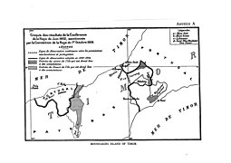 Annex A. For simplicity and clarity, some maps have been combined.
 -
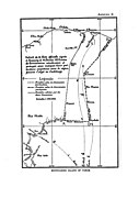 Annex B. Combines the maps of 1899 and 1904, in which the A and C lines coincided.
 -
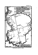 Annex C


Decolonization

In 1949, the Dutch possessions on and around Timor became independent as part of Indonesia, while Portuguese Timor initially remained an overseas province. [3] It was only after the Carnation Revolution of 1974, which removed the dictatorship of Marcello Caetano, that Portugal began to decolonise its possessions. [3] In East Timor, a civil war broke out between the two largest parties, which Indonesia used to occupy the border area. Under the threat of total invasion, the victorious FRETILIN declared the independence of the Democratic Republic of East Timor on 28 November 1975, but only nine days later Indonesia openly began to annex and occupy East Timor, reforming it under the province of Timor Timur (which uses the same border prior to the invasion without any changes). [3] [14]
The following 24 years of occupation and guerrilla warfare cost the lives of nearly 200,000 people. Finally, in 1999, under pressure from the international community, a referendum was held in which the population had the choice between independence and belonging to Indonesia as an autonomous province. 78.5 % opted for independence. East Timor came under UN administration and was finally granted independence on 20 May 2002. [3] [15] [16]
Current situation


As late as 2001, members of the Indonesian military warned that East Timor's independence could cause secessionist movements in West Timor. East Timorese separatists and irredentists have received local support in West Timor, including from the local Catholic diocese of Atambua. [17] The aim is to unite the two parts of the island into an independent " Greater Timor". In 2005, a local commission again warned against a "Great Timor grouping" in West Timor. [18] However, such a grouping did not appear in the general public and neither the government nor the major parties in East and West Timor pursue such a policy.
The current land border between East Timor and Indonesia is 268.8 km long. 149.1 km of this is the border between the main territory of East Timor and its western neighbour, the rest is the border around the East Timorese exclave of Oe-Cusse Ambeno. In order to agree on the course of the border, the Dutch-Portuguese border demarcation was used as a guideline, in accordance with the legal principle " Uti possidetis". [19] Since 8 April 2005, 97% of the border had been defined with 907 coordinate points. Still in dispute was the affiliation of the small uninhabited island of Batek Island (Fatu Sinai), 37 hectares between the East Timorese village of Memo (Suco Tapo/Memo) and the Indonesian Dilumil ( Lamaknen district, Belu Regency), where it was not possible to agree on the location of the river median of the Mathiaca (Malibaca) over a length of 2.2 km [19] and areas around the exclave of Oe-Cusse Ambeno ( Área Cruz with 142.7 hectares in Passabe, Citrana triangle in Nitibe) as well as the exact modalities of a corridor from Oe-Cusse Ambeno to the main state territory. Since 2010, there has been a special pass for traffic in the border area. In Naktuka, however, there have been repeated attacks by Indonesian soldiers on the local population since the end of 2009. [20] [21] On 21 June 2013, the dispute over the area near Dilumil/Memo was settled. [19]
The claims to the island of Fatu Sinai had allegedly been abandoned by East Timor at this point. The two territories on the border of the Oe-Cusse Ambeno exclave remained as points of contention. On 23 July 2019, following a meeting between East Timor's chief negotiator Xanana Gusm├Żo and Wiranto, Indonesia's Coordinating Minister for Political, Legal and Security Affairs, it was stated that agreement had now been reached on the course of the country's border. Negotiations on maritime borders, which had been ongoing since 2015, continued. [22] [23]
On 21 January 2022, Gusm├Żo reported to the Foreign Affairs, Defence and Security Commission of the National Parliament on the status of the negotiations. Now Naktuka and Fatu Sinai were again part of the negotiations. Negotiations on maritime borders from Batugade to Atauro and from Atauro to Jaco were also ongoing. [24]
Border crossings from East Timor's main territory to Indonesia exist at Mota'ain, near the north coast, and Motamasin, on the south coast to Indonesia's West Timor. There is no regular bus service. From Oe-Cusse Ambeno, border crossings at Napan/ Bobometo ( Oesilo administrative post), Sacato/ Wini and Passabe lead to West Timor. However, only Bobometo and Sacato are legal crossings. [25]
Border crossings


- Wini (IDN) ŌĆō Sacato (sometimes spelled Sakato) (TLS) [26]
- Motamasin (IDN) ŌĆō Salele (TLS) [27] [28]
- Mota'ain (IDN) ŌĆō Batugade (TLS) [27]
Gallery
-
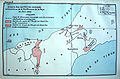
 Map of boundary changes made in 1904
 -
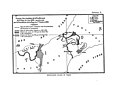
 1902 boundary map
 -
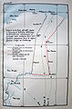
 1914 arbitration map
 -
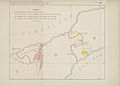
 1914 arbitration map, showing conflicting Dutch and Portuguese claims in eastern Oecusse

See also
References
- ^ "Indonesia". CIA World Factbook. Retrieved 19 September 2020.
- ^ Office of Assistant to Deputy Cabinet Secretary for State Documents & Translation (23 July 2019). "Indonesia, Timor-Leste Finalize Agreement on Land Borders". Cabinet Secretariat of the Republic of Indonesia. Retrieved 14 July 2023.
- ^ a b c d e f g h i j k l m n o Deeley, Neil (2001), The International Boundaries of East Timor, IBRU, University of Durham, retrieved 22 September 2020
- ^ Sousa, Ivo Carneiro de (2001). "The Portuguese Colonization and the Problem of East Timorese Nationalism". Lusotopie. 2001: 183ŌĆō194. Archived from the original on 23 November 2006.
- ^ a b "Gunn (1999), Timor Lorosae: 500 years (Macau: Livros do Oriente)" (PDF). p. 80. Archived from the original (PDF) on 24 March 2009. Retrieved 25 April 2009.
- ^ Tratado de demarca├¦├Żo e troca de algumas possess├Ąes portuguezas e neerlandezas no Archipelago de Solor e Timor entre sua magestade el-rei de Portugal e sua magestade el-rei dos Paizes Baixos assignado em Lisboa pelos respectivos plenipotenciarios aos 20 de abril de 1859 (in Portuguese). Lisboa: Imprensa Nacional. 1861 – via Google Books. (French text and Portuguese translation)
- ^ a b c d e f g h i The Hague. "Island of Timor: Award (Boundaries in the Island of Timor) | Netherlands versus Portugal". The Hague Justice Portal. Archived from the original on 22 Feb 2013. Retrieved 14 July 2023.
- ^ Schapper: Finding Bunaq. S. 171.
- ^ a b c Schapper, Antoinette (2011). "Crossing the border Historical and linguistic divides among the Bunaq in central Timor". Wacana, Journal of the Humanities of Indonesia. 13 (1): 29. ISSN 2407-6899.
- ^ Gunn, S. 77.
- ^ Schapper: Finding Bunaq. S. 174.
- ^ Gunn, S. 77.
- ^ Gunn, S. 92.
- ^ Ricklefs, M. C. (1991). A History of Modern Indonesia Since c. 1300 (2nd ed.). MacMillan. p. 301. ISBN 978-0-333-57689-2.
- ^ "New Country, East Timor, Is Born; UN, Which Aided Transition, Vows Continued Help". UN News Centre. 19 May 2002. Archived from the original on 10 July 2011. Retrieved 17 February 2008.
- ^ "UN General Assembly Admits Timor-Leste as 191st Member". UN News Centre. 27 September 2002. Archived from the original on 18 December 2007. Retrieved 17 February 2008.
- ^ "TNI Warns of W. Timor Rebels". Jakarta Post. 18 December 2001. Retrieved 2023-07-14 – via www.etan.org.
- ^ "Officials wary of Great Timor State". Jakarta Post. 26 February 2005. Retrieved 2023-07-14 – via www.etan.org.
- ^ a b c Fauzia Qinvi, Rida; Sutisna, Sobar; Widodo, Pujo (2018). "Diplomasi Pertahanan Dalam Penyelesaian Unresolved Segment Di Perbatasan Darat Indonesia ŌĆō Republik Demokratik Timor Leste (RDTL) (Studi Kasus Unresolved Segment Dilumil ŌĆō Memo)". Jurnal Diplomasi Pertahanan. 4 (1). Retrieved 14 July 2023.
- ^ "Grenzstreitigkeiten zwischen Indonesien und Timor-Leste drohen zu eskalieren ŌĆō Wikinews, die freie Nachrichtenquelle". de.wikinews.org (in German). Retrieved 2023-07-14.
- ^ Amarullah, Amril (7 November 2009). "Indonesia - E Timor under Borderline Dispute | TNI troops assigned to the field would obey the agreement on temporary borderline". VIVAnews. Archived from the original on 2010-02-25. Retrieved 2023-07-14.
- ^ Lusa (RTP) (2019-07-23). "Timor-Leste e Indon├®sia chegam a acordo para defini├¦├Żo de fronteira terrestre". R├Īdio e Televis├Żo de Portugal (in Portuguese). Retrieved 2023-07-14.
- ^ Parlina, Ina (27 August 2015). "RI, Timor Leste agree to resolve border problems, boost ties". The Jakarta Post. Retrieved 2023-07-14.
- ^ "Xanana aprezenta progresu negosiasaun fronteira mar├Łtima no terrestre ba PN". GMN TV. 21 January 2022. Archived from the original on 2022-07-06. Retrieved 2023-07-14 – via Archive.org.
- ^ Sutisna, Sobar; Handoyo, Sri (January 2006). "Delineation and Demarcation surveys of the land border in Timor: Indonesian perspective, Center for Boundary Mapping,". The National Agency for Surveys and Mapping of Indonesia.
- ^ "Jokowi Resmikan Pos Lintas Batas Negara Motamasin dan Wini di NTT" [Jokowi Inaugurates Motamasin and Wini Cross-Border Posts in NTT] (in Indonesian). Kompas.com. 2018-01-09. Retrieved 2019-06-10.
- ^ a b "About Us". Immigration Service of Timor-Leste. Retrieved 10 June 2019.
- ^ "Customs Contacts and Posts". Timor-Leste Ministry of Finance. Retrieved 3 July 2019.
Further reading
- "Timor-Leste: Oecusse and the Indonesian Border". International Crisis Group. 20 May 2010. Retrieved 3 August 2021.
You can help expand this article with text translated from
the corresponding article in German. (February 2024) Click [show] for important translation instructions.
|
| East TimorŌĆōIndonesia border | |
|---|---|
|
Map of the East TimorŌĆōIndonesia border | |
| Characteristics | |
| Entities | |
| Length | 253 km (157 mi) |
| Enclave and exclaves | Oecusse |
| History | |
| Established | 25 June 1914 Court of Arbitration's award |
| Current shape | 2002 East Timor independence |
| Treaties |
Treaty of Lisbon of 1859 1999 East Timorese independence referendum |
The East TimorŌĆōIndonesia border is the international border between East Timor and Indonesia. The border consists of two non-contiguous sections totalling 253 km (157 m) in length, the larger section of which divides the island of Timor in two. [1] The demarcation of the border between Indonesia and East Timor has been fought over by various parties for 350 years. The first attempts to define it precisely were made by the colonial powers of the Netherlands and Portugal with the Treaty of Lisbon in 1859, but it was not until the Permanent Court of Arbitration's award of 25 June 1914 that the final land border between them on the island of Timor was established. It largely coincides with today's border between the state of East Timor (Timor-Leste), which only gained its final independence in 2002, and West Timor, which belongs to Indonesia, but was still disputed on some points until 2019. [2]
Description
Western (Oecusse) section
The Municipality of Oecusse forms an exclave of East Timor in Indonesian West Timor (part of East Nusa Tenggara province). The border starts in the west at the coast of the Savu Sea, proceeding overland to the south to the Noel Besi River, which it then follows south, then east, then south. The border then turns east overland briefly, before turning to the north, utilising various rivers such as the Ekan, Sonau and Bilomi, before proceeding northwards overland to the Savu coast.
Eastern section
The border between Indonesia and the main part of East Timor starts in the north at the Savu Sea coast, and proceeds south and then east via the Talu river. It then turns south along the Malibacu river, and then west along the Tafara river, then south along the Massin river down to the coast at the Timor Sea.
History
Colonization
The division of the island of Timor dates to the colonial period. During the 15thŌĆō16th centuries both the Netherlands and Portugal began taking an interest in the Spice Islands of modern Indonesia. [3] The Portuguese first landed on Timor in 1512 and established their first settlement in Lifau in western Timor in 1556. The Dutch followed shortly after, but did not establish themselves in the west of the island until 1640[ citation needed] when the Dutch started to occupy the western half of the island as part of its Dutch East Indies colony. [3] In 1642, the Portuguese conquered the island's spiritual centre at Wehale, after which most Timorese rulers ( Liurai) recognised Portugal's dominance. Thus,[ citation needed] Portugal started to occupy the eastern half of Timor and declared the creation of Portuguese Timor. [4] [5] In 1656, the Dutch conquered the Portuguese base at Kupang. In 1749, an attempted reconquest by the Portuguese failed at the Battle of Penfui, whereupon most rulers in the west signed treaties with the Dutch East India Company. Among them was a certain Jacinto Correa, King of Wewiku-Wehale and Grand Prince of Belu, who also signed the dubious Treaty of Paravicini on behalf of many territories in central Timor. Fortunately for the Portuguese, Wehale was no longer powerful enough to draw the local rulers to the side of the Dutch. Thus the eastern former vassals of Wehale remained under the flag of Portugal, while Wehale itself fell under Dutch rule. The result was a permanent dispute over the boundaries of the spheres of influence of the colonial powers. [5]
Negotiations between the colonial powers in the 19th century
In 1851, the Portuguese governor Jos├® Joaquim Lopes de Lima reached an agreement with the Dutch on the division of the colonies in the Lesser Sunda Islands. However, this was not authorised by Lisbon, which is why the agreements were only confirmed in the Treaty of Lisbon in 1859 after new negotiations from 1854. On 20 April 1859 a treaty was signed (ratified 1860) which formally divided the island between the Netherlands and Portugal, with a border based on existing Timorese states which were assigned to either Portugal or the Netherlands. [3] [6] However, the exact course of the border was still unclear, and with Portuguese Noimuti and Dutch Maucatar, there was also one enclave each of the colonial power without access to the sea on the side of the competitor.
On 10 June 1893, An additional treaty, the Lisbon Convention, was then signed between the governments, with the intention of creating favourable conditions "for the development of civilisation and trade" and for the dissolution of the still existing enclaves (ratified 1894). A commission of experts was to be convened for the new demarcation of borders. If difficulties arose, a mediator was to be called in. The commission visited Timor and came to an agreement on most of the border between 1898 and 1899. The problem with the enclaves of Noimuti and Maucatar remained unresolved. The original reason of the Dutch for this round of negotiations was the desire for a right of first refusal for East Timor. [3] There were rumours that Russia and Germany wanted to establish a coal station in Portuguese Timor, respectively that the colony would be exchanged for the recognition of Portuguese claims in Africa with Germany, France or England. [7] In fact, on 30 August 1898, Germany and Britain agreed in the Angola Treaty on a joint bond for the heavily indebted Portugal, for which the Portuguese colonies were intended as a pledge. In the event of insolvency, Portuguese Timor would have fallen to Germany. As early as 1899, however, the treaty was undermined by the extension of the British guarantee of protection for Portugal and all its possessions. [3]
In 1897, fighting broke out over Lamaknen between Lamaquitos, which was under Portuguese sovereignty, and Dutch-dominated Lakmaras. [8] In Lakmaras itself, skirmishes between the two colonial forces resulted in casualties. [9] Between 23 June and 3 July 1902, there was another conference in The Hague. [3] It was argued whether Oe-Cusse Ambeno was part of the Lisbon Convention on the exchange of enclaves or not. Portugal objected, saying that the area had a coastal course and therefore did not fall under the definition of an enclave. [10] The Dutch claim to Maucatar had previously been based on their suzerainty over Lakmaras, which created a link to Maucatar. In the meantime, however, Lakmaras had become a subject of the Empire of Lamaquitos in the Portuguese sphere of power and Maucatar would have to fall to Portugal as an enclave according to the previous agreements. [7] [9] [11] On the other hand, the Tahakay Empire (Tahakai, Tafakay, Takay) had in the meantime fallen to the Lamaknen Empire. Tahakay, however, belonged to the Portuguese sphere of influence, Lamaknen to the Dutch. Portugal resisted this loss in the negotiations and therefore now demanded the entire Dutch territories in central Timor. [9] A compromise was reached with the Hague Convention of 1 October 1904. Portugal was to receive the Dutch enclave of Maucatar in exchange for the Portuguese enclave of Noimuti and the border areas of Tahakay, Tamira Ailala (Tamiru Ailala) and Lamaknen. The disputed territories in the east of Oe-Cusse Ambeno were granted to the Dutch. The border was defined from the confluence of the No├©l Bilomi and O├© Sunan, following the Thalweg path of the O├© Sunan, continuing through Nipani and Kelali (Keli) to the source of the No├©l Meto, and following its valley path to its mouth. In addition, the Dutch now secured the right of first refusal for East Timor. Portugal ratified the treaty until 1909, but then a dispute arose over the demarcation of the eastern border of Oe-Cusse Ambeno. [12] In 1910, the Netherlands took advantage of the confused situation after the fall of the Portuguese monarchy to seize Lakmaras again with European and Javanese troops. [13]
Problems with surveying
Between 1 and 10 June 1909, a commission carried out a survey of the eastern boundary of Oecussi-Ambeno, but could not agree on the correct course and decided to transfer the open questions back to their governments. [7]
The commission had started surveying in the north on the coast and followed the course of the No├©l Meto southwards. Its source served as a measuring point. However, the way to the source was blocked by steep cliffs that could not be overcome, so the surveyors decided to survey only the areas to the north and south. Thus, an area between the source of the No├©l Meto in the north and the course of the No├©l Bilomi in the south was missing. Discrepancies arose first in the north. On the 1904 map (Annex III), the name Kelali was found with Keli in brackets. The Dutch assigned this mark to the summit of Mount Kelali. This lies to the west of the No├©l Meto between two pointed rocks and was given by the inhabitants of the Dutch Tumbaba as the border to the Portuguese Ambeno. Instead, the Portuguese asked to follow the valley paths east of it. [7]
In the southern part, the commission investigated the demarcation along the course of the Nono Nisi (Nise) on 17 June 1909, then further along the course of the No├©l Bilomi, finally arriving at the point where the 1899 expedition had finished its work. The point was marked on the 1904 map as the confluence of the No├©l Bilomi and the O├© Sunan. The present commission found two northern tributaries here, but neither of them had the name O├© Sunan. The Dutch explained this by saying that the area between the tributaries was called Sunan and that there was actually no tributary named O├© Sunan, although the confluence was the starting point of the boundary demarcation on the 1899 and 1904 maps. The Portuguese noted that there was a river further east called O├© Sunan or Oil Sunan, which was not a tributary of the No├©l Bilomi, but whose source was in the "very close to the No├©l Bilomi". Finally, the commission agreed that there is no tributary called O├© Sunan on the No├©l Bilomi, but that the river changes its name. The Portuguese stressed that this meant that the No├©l Bilomi still existed. [7]
The Dutch delegation explained that the Bilomi had changed names in this region. "Yes, the river exists," the Portuguese replied, "but, according to indigenous tradition, it bears the name of the area it is crossing". Finally, the Portuguese delegation added, not very far from the north bank of the Bilomis stands Mount Kinapua. On its opposite slope, the O├© Sunan flows towards the north. It was only necessary to follow this river course, then up the Noi Fulan river to its source and finally connect it with the source of the No├©l Meto, which had already been recognised by the joint commission. [7]
However, the Dutch felt that there was no point in pursuing the survey of this river, as both Mount Kinapua and the border area that would be created under the Portuguese proposal were outside the territory contested in 1899. Mount Tasonal appears on the 1899 map on the farthest eastern boundary of the then Portuguese claims, which were rejected by the 1904 Agreement. In this respect, a border area going even further east is out of the question. There were numerous areas of the boundary which the two sides were unable to come to agreement on, prompting a further conference held at The Hague in 1902. A treaty was subsequently signed on 1 October 1904 (ratified 1908) which created the modern boundary, removing a number of enclaves whilst leaving the exclave of Oecusse as part of Portuguese Timor. [3]
However, whilst demarcating the boundary on the ground in 1909, the two sides were unable to agree to the alignment of the eastern section of the Oecusse boundary. [3] The Joint Commission interrupted its work here and the question, meanwhile taken over by the diplomatic services, caused endless correspondence between the cabinets in The Hague and Lisbon. Out of this correspondence came the 1913 Convention, which gave an arbitrator the right to decide, according to the "facts supplied by the two parties" and "on the basis of general fundamental rights, how the boundary from the No├©l Bilomi to the source of the No├©l Metos, in accordance with Article 3, Number 10 of the Den Hagen Agreement of 1 October 1904... should run." [7]
As the governments could not agree, it was decided to refer the matter Permanent Court of Arbitration in 1913. [3]
Court of Arbitration in The Hague
The Portuguese point of view
The Portuguese government made the following points: [7]
- The tributary to the No├©l Bilomi called O├© Sunan, which was at the point where the work was stopped in 1899, or which is indicated in the contract and map of 1904, does not exist.
- Instead, further east there is a river called O├© Sunan, which is not a tributary of the No├©l Bilomi, but has its source near its north loop at Mount Kinapua. The mountain and the O├© Sunan are considered by many local rulers to be the border point between the Portuguese Ambeno and the Dutch territories of Tumbaba and Amakono. A stream flows from Kinapua towards No├©l Bilomi, so the peak can serve as a link between the two watercourses.
- according to the indigenous rulers, the Ambeno border runs east along the O├© Sunan and north along the Ni Fullan river. To the west of the Kelali and Netton mountains lies Oecussi, which indisputably belongs to Portugal. A map by a private citizen published in Batavia even refers to the entire area claimed by the Netherlands as Ambeno.
- The treaty of 1859 is based on the principle that the native kingdoms should not be divided. Ambeno, however, will be divided with the Dutch proposed border demarcation and the inhabitants will be deprived of their pastures and fields which would then be in Dutch territory.
- there is no evidence that the boundary to be demarcated should necessarily start at the point where the demarcation work was suspended in 1899 due to hostilities between the natives and where the maps show the confluence of the Bilomi and O├© Sunan rivers, but which is not at that location. There are two streams at this place, the Kamboun and the Nono-Offi. Why follow the course of the Kamboun to the north instead of the Nono-Offi, which comes from the northeast and joins the Bilomi at this point?
- In the view of the Portuguese government, it was only desirable to give the Boundary Commissioners a sketch, using the 1899 and 1904 maps, for the purpose of fixing ideas, and as a vague and simple indication of what was to be settled later.
- The real intention of the signatories to the 1904 Treaty was to follow the course of the O├© Sunan where it actually lies, that is, much further east. In terms of the treaty, therefore, nothing prevents the Bilomi from rising to the point closest to the source of the true O├© Sunan, a source so close to the course of the Bilomi that it is almost a tributary.
- the line proposed by the Netherlands to "cross as far as possible Nipani and Kelali (Keli)" according to the 1904 treaty does not cross Nipani but only touches the Fatu Nipani, i.e. the western end of the Nipani. Therefore, it does not correspond to the 1904 plan.
- the line proposed by the Netherlands is not a natural boundary, while the line proposed by Portugal follows watercourses for almost its entire length.
The Dutch point of view
The main arguments of the government of the Netherlands can be summarized as follows: [7]
- The 1859 Treaty does not mandate that native territories should not be partitioned or parceled out. On the contrary, it assigned to Portugal the state of Ambeno "wherever the Portuguese flag is set there", but does not thereby prohibit the partition of an indigenous state, but calls for the partition of the state of Ambeno precisely by saying: "The Netherlands cede to Portugal ... that part of the state of Ambenu or Ambeno which for several years has flown the Portuguese flag."
- There is no uncertainty as to the place where the border commissioners ceased in 1899. This point served as the basis for the 1902 negotiations and was marked on the map (Annex III) signed by the negotiating parties at that time to be attached to the draft treaty. This 1902 draft became the 1904 Treaty. From this point, and from no other point, begins the line AC, which was recognised in 1902 as a duly constituted boundary (Map Annex I). This line AC extends northwards from this point to the source of the river No├©l Meto, and the boundary was then to follow this watercourse to its mouth in the sea to the north.
- The location of the source of the No├©l Meto was recognised differently in 1909: A marker was placed there by mutual agreement. The discussion concerned only the elevation between this source and point A, which was at the place where the commissioners stopped in 1899.
- On the official map of 1899 (Appendix IV), as on the official map of 1904 (Appendix III), a tributary to which the name O├© Sunan was given by a mistake which the Netherlands do not dispute, is shown as coming from the north to the point in question. This tributary, which in reality bears the name of Kabun among the Tumbabas and that of L├©os among the Ambenos, is entirely in accordance with the intention of the contracting parties, which was that a tributary coming from the north should take the direction of AC from point A. The mistake in the name has less significance, since the watercourses in this region very often have several names or change their names or bear the name of the country they cross: the region east of the Kabun or L├©os (the O├© Sunan of 1904) has the name Hue Son, according to the Portuguese government, a similar sound, and the name Sunan according to the Dutch commissioners, which could explain the mistake of the commissioners.
- The native rulers of Amakono (Dutch) declared (Joint Commission meeting of 21 February 1899) that their land comprised the entire region lying between O├© Sunan, Nipani, Kelali-Keli and No├©l Meto (to the west), the Sea of Timor (to the north), the No├©l Boll Bass, the Humusu and Kin Napua mountains (to the east), Tasona, the No├©l Boho and the No├©l Bilomi (to the south). The western boundary described in 1899 between the Dutch Amakono and the Portuguese Ambeno is that established by the 1904 Treaty. The O├© Sunan that appears there can only be the watercourse that was mistakenly entered in the official maps of 1899 and 1904 by mutual agreement, i.e. a watercourse to the west of the disputed territory and not the alleged O├© Sunan to which Portugal now refers and which lies on the eastern border of the disputed territory. The 1904 Treaty assigned this disputed territory to the Netherlands. The border is therefore supposed to be on the watercourse to the west, whatever it is called.
- The proof that Portugal in 1899 and 1904 could not have taken into account the eastern stream, to which it now gives the name of O├© Sunan, is the fact that its Commissioners in the meeting of 21. February 1899 proposed as a boundary a line beginning at the point where the stream now called O├© Sunan joins the Bilomi, and then following the No├©l Bilomi eastwards to Nunkala├» (then crossing Tasona and going north from Kin Napua to Humusu and to the source of the No├©l Boll Bass, the course of which would have served as the boundary to its mouth at sea). This Portuguese proposal of 1899 would be incomprehensible if it were a different river from the one that appears on the official maps of 1899 and 1904 under the name O├© Sunan. How could it be a different O├© Sunan river that lies to the east of Nunkala├», since the Nunkala├» in fact lies to the west and not to the east of this new O├© Sunan discovered by the Portuguese?
- Two recent investigations launched by the Dutch authorities on Timor also confirmed that no river named O├© Sunan rises on Mount Kinapua. The stream, which rises on the northern slope at some distance from the summit, is named Poeamesse and Noilpolan and flows into the No├©l Manama, the Ni Fullan of the Portuguese maps, at Fatoe Metassa (the Fatu Mutassa of the Portuguese).
- Although the line proposed by the Netherlands does not cross the territory of Nipani, the 1904 Treaty does not require this. It provides that the line connecting the source of the O├© Sunan and the source of the No├©l Meto should cross "Nipani as far as possible". Since the area to be delimited was unexplored, the words "as far as possible" were justified. In fact, the line proposed by the Netherlands, if it crosses the Nipani area at all, crosses the western extremity called Fatu Nipani. Now, according to statements recorded in the process of demarcation on 21 February 1899, the natives designated the O├© Sunan, Nipani, Kelali and the No├©l Meto as the eastern boundary of Oe-Cusse Ambeno (Portuguese) and the western boundary of Amakono (Dutch). They thought of the rocky Fatu Nipani, as the western end of Nipani.
- The border proposed by the Dutch is a natural border formed by a mountain range that completely separates the watercourses. In the years from 1902 to 1904, it was never prescribed or recommended to follow watercourses alone for demarcation. And on the northern boundary of Oe-Cusse Ambeno, especially where the boundary line runs from the catchment of one river to the other, arrangements were made at many places.
- It will also be sufficient to mark the boundary on the ridge line proposed by the Netherlands for a few metres.
- The survey that Portugal is submitting itself calls for surveys in the region around Mount Kinapua, between the Bilomi and the alleged new O├© Sunan and elsewhere in the region, between the source of the No├©l Meto and the stream to which the Portuguese have given the name Ni-Fullan, that is, at both ends of the Portuguese surveys.
- The boundary line that Portugal proposes today repeats its claims of 1899 and 1902 in this region. It is now undisputed that by adopting the A C line at the 1902 Conference and incorporating it into the 1904 Treaty, Portugal ceded the territory to which it had previously laid claim. Accordingly, it cannot renew its claim to the same territory today.
The Arbitration
Article 3, number 10, of the Convention concluded at The Hague, October 1, 1904, concerning the delimitation of Dutch and Portuguese possessions in the Island of Timor, ought to be interpreted in conformity with the conclusions of the Royal Government of the Netherlands as to the boundary from the No├©l Bilomi as far as the source of the Noel Meto; consequently there will be a survey of that part of the frontier on the basis of the map at 1/50,000 annexed under No. IV of the first Memorial deposited with the arbitrator by the Dutch Government. A reproduction of this map signed by the arbitrator is appended as annex VII to the present award of which it shall be an integral part.
Expenses, fixed at 2,000 francs, have been deducted from the sum of 4,000 francs placed in the hands of the arbitrator in execution of art. 8 of the compromis of April 3, 1913; the remainder, or 2,000 francs, will be remitted in equal shares to the two Parties and against receipt, at the time of the notification of the award.
Seal of the Permanent Court of Arbitration Done in triplicate of which one copy shall be delivered, against receipt by the Secretary General of the International Bureau of the Permanent Court of Arbitration at The Hague, to His Excellency the Minister of Foreign Affairs of the Netherlands to serve as notification to the Royal Government of the Netherlands, and of which the second shall be delivered on the same day and in the same manner to His Excellency the Envoy Extraordinary and Minister Plenipotentiary of the Portuguese Republic to H.M. the Queen of the Netherlands, to serve as notification to the Government of the Portuguese Republic. The third shall be deposited in the archives of the International Bureau of the Permanent Court of Arbitration.
Paris, June 25, 1914.
ŌĆö The Hague, On the boundaries in the Island of Timor, Netherlands v. Portugal
The Swiss judge Charles ├ēdouard Lardy of the Permanent Court of Arbitration in The Hague thus ended a centuries-old dispute in favour of the Netherlands on 26 June 1914. [3] In 1915 various overland sections of the boundary were demarcated on the ground by erecting boundary posts. [3]
-
Annex A. For simplicity and clarity, some maps have been combined.
-
Annex B. Combines the maps of 1899 and 1904, in which the A and C lines coincided.
-
Annex C
Decolonization
In 1949, the Dutch possessions on and around Timor became independent as part of Indonesia, while Portuguese Timor initially remained an overseas province. [3] It was only after the Carnation Revolution of 1974, which removed the dictatorship of Marcello Caetano, that Portugal began to decolonise its possessions. [3] In East Timor, a civil war broke out between the two largest parties, which Indonesia used to occupy the border area. Under the threat of total invasion, the victorious FRETILIN declared the independence of the Democratic Republic of East Timor on 28 November 1975, but only nine days later Indonesia openly began to annex and occupy East Timor, reforming it under the province of Timor Timur (which uses the same border prior to the invasion without any changes). [3] [14]
The following 24 years of occupation and guerrilla warfare cost the lives of nearly 200,000 people. Finally, in 1999, under pressure from the international community, a referendum was held in which the population had the choice between independence and belonging to Indonesia as an autonomous province. 78.5 % opted for independence. East Timor came under UN administration and was finally granted independence on 20 May 2002. [3] [15] [16]
Current situation
As late as 2001, members of the Indonesian military warned that East Timor's independence could cause secessionist movements in West Timor. East Timorese separatists and irredentists have received local support in West Timor, including from the local Catholic diocese of Atambua. [17] The aim is to unite the two parts of the island into an independent " Greater Timor". In 2005, a local commission again warned against a "Great Timor grouping" in West Timor. [18] However, such a grouping did not appear in the general public and neither the government nor the major parties in East and West Timor pursue such a policy.
The current land border between East Timor and Indonesia is 268.8 km long. 149.1 km of this is the border between the main territory of East Timor and its western neighbour, the rest is the border around the East Timorese exclave of Oe-Cusse Ambeno. In order to agree on the course of the border, the Dutch-Portuguese border demarcation was used as a guideline, in accordance with the legal principle " Uti possidetis". [19] Since 8 April 2005, 97% of the border had been defined with 907 coordinate points. Still in dispute was the affiliation of the small uninhabited island of Batek Island (Fatu Sinai), 37 hectares between the East Timorese village of Memo (Suco Tapo/Memo) and the Indonesian Dilumil ( Lamaknen district, Belu Regency), where it was not possible to agree on the location of the river median of the Mathiaca (Malibaca) over a length of 2.2 km [19] and areas around the exclave of Oe-Cusse Ambeno ( Área Cruz with 142.7 hectares in Passabe, Citrana triangle in Nitibe) as well as the exact modalities of a corridor from Oe-Cusse Ambeno to the main state territory. Since 2010, there has been a special pass for traffic in the border area. In Naktuka, however, there have been repeated attacks by Indonesian soldiers on the local population since the end of 2009. [20] [21] On 21 June 2013, the dispute over the area near Dilumil/Memo was settled. [19]
The claims to the island of Fatu Sinai had allegedly been abandoned by East Timor at this point. The two territories on the border of the Oe-Cusse Ambeno exclave remained as points of contention. On 23 July 2019, following a meeting between East Timor's chief negotiator Xanana Gusm├Żo and Wiranto, Indonesia's Coordinating Minister for Political, Legal and Security Affairs, it was stated that agreement had now been reached on the course of the country's border. Negotiations on maritime borders, which had been ongoing since 2015, continued. [22] [23]
On 21 January 2022, Gusm├Żo reported to the Foreign Affairs, Defence and Security Commission of the National Parliament on the status of the negotiations. Now Naktuka and Fatu Sinai were again part of the negotiations. Negotiations on maritime borders from Batugade to Atauro and from Atauro to Jaco were also ongoing. [24]
Border crossings from East Timor's main territory to Indonesia exist at Mota'ain, near the north coast, and Motamasin, on the south coast to Indonesia's West Timor. There is no regular bus service. From Oe-Cusse Ambeno, border crossings at Napan/ Bobometo ( Oesilo administrative post), Sacato/ Wini and Passabe lead to West Timor. However, only Bobometo and Sacato are legal crossings. [25]
Border crossings
- Wini (IDN) ŌĆō Sacato (sometimes spelled Sakato) (TLS) [26]
- Motamasin (IDN) ŌĆō Salele (TLS) [27] [28]
- Mota'ain (IDN) ŌĆō Batugade (TLS) [27]
Gallery
-
Map of boundary changes made in 1904
-
1902 boundary map
-
1914 arbitration map
-
1914 arbitration map, showing conflicting Dutch and Portuguese claims in eastern Oecusse
See also
References
- ^ "Indonesia". CIA World Factbook. Retrieved 19 September 2020.
- ^ Office of Assistant to Deputy Cabinet Secretary for State Documents & Translation (23 July 2019). "Indonesia, Timor-Leste Finalize Agreement on Land Borders". Cabinet Secretariat of the Republic of Indonesia. Retrieved 14 July 2023.
- ^ a b c d e f g h i j k l m n o Deeley, Neil (2001), The International Boundaries of East Timor, IBRU, University of Durham, retrieved 22 September 2020
- ^ Sousa, Ivo Carneiro de (2001). "The Portuguese Colonization and the Problem of East Timorese Nationalism". Lusotopie. 2001: 183ŌĆō194. Archived from the original on 23 November 2006.
- ^ a b "Gunn (1999), Timor Lorosae: 500 years (Macau: Livros do Oriente)" (PDF). p. 80. Archived from the original (PDF) on 24 March 2009. Retrieved 25 April 2009.
- ^ Tratado de demarca├¦├Żo e troca de algumas possess├Ąes portuguezas e neerlandezas no Archipelago de Solor e Timor entre sua magestade el-rei de Portugal e sua magestade el-rei dos Paizes Baixos assignado em Lisboa pelos respectivos plenipotenciarios aos 20 de abril de 1859 (in Portuguese). Lisboa: Imprensa Nacional. 1861 – via Google Books. (French text and Portuguese translation)
- ^ a b c d e f g h i The Hague. "Island of Timor: Award (Boundaries in the Island of Timor) | Netherlands versus Portugal". The Hague Justice Portal. Archived from the original on 22 Feb 2013. Retrieved 14 July 2023.
- ^ Schapper: Finding Bunaq. S. 171.
- ^ a b c Schapper, Antoinette (2011). "Crossing the border Historical and linguistic divides among the Bunaq in central Timor". Wacana, Journal of the Humanities of Indonesia. 13 (1): 29. ISSN 2407-6899.
- ^ Gunn, S. 77.
- ^ Schapper: Finding Bunaq. S. 174.
- ^ Gunn, S. 77.
- ^ Gunn, S. 92.
- ^ Ricklefs, M. C. (1991). A History of Modern Indonesia Since c. 1300 (2nd ed.). MacMillan. p. 301. ISBN 978-0-333-57689-2.
- ^ "New Country, East Timor, Is Born; UN, Which Aided Transition, Vows Continued Help". UN News Centre. 19 May 2002. Archived from the original on 10 July 2011. Retrieved 17 February 2008.
- ^ "UN General Assembly Admits Timor-Leste as 191st Member". UN News Centre. 27 September 2002. Archived from the original on 18 December 2007. Retrieved 17 February 2008.
- ^ "TNI Warns of W. Timor Rebels". Jakarta Post. 18 December 2001. Retrieved 2023-07-14 – via www.etan.org.
- ^ "Officials wary of Great Timor State". Jakarta Post. 26 February 2005. Retrieved 2023-07-14 – via www.etan.org.
- ^ a b c Fauzia Qinvi, Rida; Sutisna, Sobar; Widodo, Pujo (2018). "Diplomasi Pertahanan Dalam Penyelesaian Unresolved Segment Di Perbatasan Darat Indonesia ŌĆō Republik Demokratik Timor Leste (RDTL) (Studi Kasus Unresolved Segment Dilumil ŌĆō Memo)". Jurnal Diplomasi Pertahanan. 4 (1). Retrieved 14 July 2023.
- ^ "Grenzstreitigkeiten zwischen Indonesien und Timor-Leste drohen zu eskalieren ŌĆō Wikinews, die freie Nachrichtenquelle". de.wikinews.org (in German). Retrieved 2023-07-14.
- ^ Amarullah, Amril (7 November 2009). "Indonesia - E Timor under Borderline Dispute | TNI troops assigned to the field would obey the agreement on temporary borderline". VIVAnews. Archived from the original on 2010-02-25. Retrieved 2023-07-14.
- ^ Lusa (RTP) (2019-07-23). "Timor-Leste e Indon├®sia chegam a acordo para defini├¦├Żo de fronteira terrestre". R├Īdio e Televis├Żo de Portugal (in Portuguese). Retrieved 2023-07-14.
- ^ Parlina, Ina (27 August 2015). "RI, Timor Leste agree to resolve border problems, boost ties". The Jakarta Post. Retrieved 2023-07-14.
- ^ "Xanana aprezenta progresu negosiasaun fronteira mar├Łtima no terrestre ba PN". GMN TV. 21 January 2022. Archived from the original on 2022-07-06. Retrieved 2023-07-14 – via Archive.org.
- ^ Sutisna, Sobar; Handoyo, Sri (January 2006). "Delineation and Demarcation surveys of the land border in Timor: Indonesian perspective, Center for Boundary Mapping,". The National Agency for Surveys and Mapping of Indonesia.
- ^ "Jokowi Resmikan Pos Lintas Batas Negara Motamasin dan Wini di NTT" [Jokowi Inaugurates Motamasin and Wini Cross-Border Posts in NTT] (in Indonesian). Kompas.com. 2018-01-09. Retrieved 2019-06-10.
- ^ a b "About Us". Immigration Service of Timor-Leste. Retrieved 10 June 2019.
- ^ "Customs Contacts and Posts". Timor-Leste Ministry of Finance. Retrieved 3 July 2019.
Further reading
- "Timor-Leste: Oecusse and the Indonesian Border". International Crisis Group. 20 May 2010. Retrieved 3 August 2021.