-
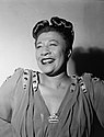 Ella Fitzgerald, 1946
 -
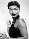 Pearl Bailey, c. 1960
 -
 Hazel O'Leary, 1993
Photos • Location

36°58′36″N 76°24′24″W / 36.97667°N 76.40667°W
This article needs additional citations for
verification. (June 2020) |
The East End is an area of the independent city of Newport News, Virginia, located in the older portion of the port city near the harbor of Hampton Roads.
_b.jpg)

.jpg)
- Aaron Brooks – American football player (born 1976)
- Earl Faison – American football player (1939–2016), attended Huntington High School [1]
- Ella Fitzgerald – American jazz singer (1917–1996) [2]
- Hazel R. O'Leary – American government official and university administrator [3]
- Joe Durham – American baseball player and coach (1931-2016), attended Huntington High School[ citation needed]
- Marcus Vick – American football player (born 1984)
- Michael Vick – American football player (born 1980)
- Pearl Bailey – American actress and singer (1918–1990)

.JPG)
.JPG)
- Collis P. Huntington High School – Former African-American high school during the racial segregation era
- J. Thomas Newsome House – Historic home, museum, and cultural center
- James A. Fields House – Historic house
- Smith's Pharmacy – Historic commercial building
- Whittaker Memorial Hospital – Hospital in Newport News, Virginia, United States
- ^ O'Brien, Marty (September 24, 2004). "Earl Faison". dailypress.com. Retrieved June 13, 2020.
- ^ Whitaker, Matthew (2011). Icons of Black America: Breaking Barriers and Crossing Boundaries. Vol. v. 1. Santa Barbara, CA, US: Greenwood. p. 302. ISBN 9780313376436. OCLC 781709336.
- ^ Di Vincenzo, Mark (April 4, 1994). "High Profile: Hazel O'Leary". dailypress.com. Retrieved June 13, 2020.
|
| This City of Newport News, Virginia state location article is a stub. You can help Wikipedia by expanding it. |
| Topics |  | |
|---|---|---|
| Parks | ||
| Historic sites and museums | ||
| Military | ||
| Neighborhoods | ||
| Education | ||
| Transportation | ||
| Media | ||
36°58′36″N 76°24′24″W / 36.97667°N 76.40667°W
This article needs additional citations for
verification. (June 2020) |
The East End is an area of the independent city of Newport News, Virginia, located in the older portion of the port city near the harbor of Hampton Roads.
-
Ella Fitzgerald, 1946
-
Pearl Bailey, c. 1960
-
Hazel O'Leary, 1993
- Aaron Brooks – American football player (born 1976)
- Earl Faison – American football player (1939–2016), attended Huntington High School [1]
- Ella Fitzgerald – American jazz singer (1917–1996) [2]
- Hazel R. O'Leary – American government official and university administrator [3]
- Joe Durham – American baseball player and coach (1931-2016), attended Huntington High School[ citation needed]
- Marcus Vick – American football player (born 1984)
- Michael Vick – American football player (born 1980)
- Pearl Bailey – American actress and singer (1918–1990)
- Collis P. Huntington High School – Former African-American high school during the racial segregation era
- J. Thomas Newsome House – Historic home, museum, and cultural center
- James A. Fields House – Historic house
- Smith's Pharmacy – Historic commercial building
- Whittaker Memorial Hospital – Hospital in Newport News, Virginia, United States
- ^ O'Brien, Marty (September 24, 2004). "Earl Faison". dailypress.com. Retrieved June 13, 2020.
- ^ Whitaker, Matthew (2011). Icons of Black America: Breaking Barriers and Crossing Boundaries. Vol. v. 1. Santa Barbara, CA, US: Greenwood. p. 302. ISBN 9780313376436. OCLC 781709336.
- ^ Di Vincenzo, Mark (April 4, 1994). "High Profile: Hazel O'Leary". dailypress.com. Retrieved June 13, 2020.
|
| This City of Newport News, Virginia state location article is a stub. You can help Wikipedia by expanding it. |
| Topics | | |
|---|---|---|
| Parks | ||
| Historic sites and museums | ||
| Military | ||
| Neighborhoods | ||
| Education | ||
| Transportation | ||
| Media | ||