| Review waiting, please be patient.
This may take 4 months or more, since drafts are reviewed in no specific order. There are 2,741 pending submissions waiting for review.
Where to get help
How to improve a draft
You can also browse Wikipedia:Featured articles and Wikipedia:Good articles to find examples of Wikipedia's best writing on topics similar to your proposed article. Improving your odds of a speedy review To improve your odds of a faster review, tag your draft with relevant WikiProject tags using the button below. This will let reviewers know a new draft has been submitted in their area of interest. For instance, if you wrote about a female astronomer, you would want to add the Biography, Astronomy, and Women scientists tags. Editor resources
Reviewer tools
|

The Autun oil shale deposit is a sedimentary basin containing oil shale of the Autunian age (between 299 and 282 million years old) in the vicinity of Autun in Saône-et-Loire, in the center-east of France.
The extraction of the shale commenced in 1824 at Igornay. Oil shale production began as early as 1837 for public lighting purposes, with facilities undergoing continuous improvement to diversify production. The largest of these facilities was the Télots mine, which was equipped with a refinery in 1936 and employed several hundred workers to produce automobile fuel. This mine was the last to close in 1957. The total production of the deposit is estimated at 13 million tons.
The vestiges of this industrial activity, in the form of ruins and slag heaps, persist in the early 21st century, particularly in the villages of Dracy-Saint-Loup, Saint-Forgeot, and Tavernay.

The deposit is situated in a valley in the Morvan, spanning the territories of the communes of Autun, Dracy-Saint-Loup, Igornay, Saint-Forgeot, Tavernay, and other neighboring communes in the north of the Saône-et-Loire department, in the Bourgogne-Franche-Comté region in the Grand Est of France. [1]
The sedimentary basin is an underground depression with an east-west orientation, measuring approximately 30 km in length and reaching a maximum width of 12 km. [1]
The Autun basin is in direct proximity to the Épinac coal basin. The two deposits have a significant degree of overlap and are even jointly exploited in the communes of Sully and Saint-Léger-du-Bois. [2]
The Autun oil shale deposit has lent its name to the geological period during which it was formed, the Autunian, which spans between -299 and -282 million years ago. [3] The deposit measures 1.3 km in thickness [2] and has never been fully traversed. The deepest shaft, La Brasserie, reaches a depth of 463 meters. [4] The oil shale layers are interspersed with fine detrital sediments, including limestone. The layers form lenses whose thickness and quality vary greatly. The deposit is based on the Stephanian coal foundation of Épinac. [2]
The basin is divided into two stratigraphic units, which are subdivided into two beds: [4]
- Lower Autunian:
- The Igornay bed is situated directly on the Moloy ( Saint-Léger-du-Bois) coal terrain. It has a thickness ranging from 150 to 230 meters, comprising alternating layers of bituminous and non-bituminous coal, overlain by a substantial sandstone layer.
- The Muse bed is 400 meters in thickness and includes bituminous layers, namely the Laly and Muse layers.
- Upper Autunian:
- The Surmoulin bed ( Dracy-Saint-Loup) has a thickness of 250 meters and comprises, in its lower portion, the extensive Surmoulin oil shale layer.
- The Millery bed ( Saint-Forgeot) is 250 meters in length and consists of shale intermingled with detrital rock. It contains ten layers of bitumen, which have been significantly mined at the Télots mine. The upper layer is composed of boghead, a type of bituminous coal.
The deposit was initially identified in 1813 at Igornay, and extraction commenced in 1824 within this commune. The industrial production of oil shale began in 1837 for public lighting in several major cities, including Paris, Lyon, Dijon, and Strasbourg. [5] [i 1] [o 1] [i 2] To extract the oil, the shale is crushed and then heated to a temperature between 450 and 500 °C in a confined, airless space. The escaping vapor is then condensed to obtain a liquid material similar to petroleum. [i 3] Despite facing competition from coal gas in 1847, the production of Autun lamp oil rebounded quickly. [o 2]
1864 and 1865 represented a period of peak profitability for shareholders, with a 30% return on investment. In 1865, approximately 6,700 tons of oil were extracted from oil shales, [o 3] utilizing approximately twenty extraction sites and sixteen processing plants. [6]
Towards the conclusion of the nineteenth century, shale was extracted at depths reaching 300 meters below the surface. The advent of competition from American and Russian oil in 1870 led to the demise of several concessions. In 1881, the Société Lyonnaise des Schistes Bitumineux (SLSB) purchased several remaining concessions to restart production with new private capital and state aid. This resulted in the company obtaining a monopoly in 1891. Surface installations were progressively completed from 1840 to 1870, particularly for the production of oil, paraffin, sulfates, and ammonia. However, the latter products were abandoned after World War I. [5] [i 1] [o 1] [o 2] [6] [i 4]
In 1892, the state implemented a reduction in customs duties on imported oils, thereby enhancing their competitive position vis-à-vis Autun oil shale. To offset this, premiums were introduced, enabling the modernization of installations and a 30% increase in crude oil yield. After the 1914 mobilization, the mines and factories of Ravelon ( Dracy-Saint-Loup) and Margenne ( Monthelon) were compelled to cease operations. The exploitation of the oil shale deposits was concentrated at the Télots and Surmoulin sites, in the Dracy-Saint-Loup region. In 1933, a legislative measure was enacted that granted tax exemption for fuels derived from oil shale, thereby opening up new avenues for exploration. The implementation of social reforms by the Popular Front in 1936 led to a reduction in the profitability of the SLSB. A new company, the Société Minière des Schistes Bitumineux (SMSB), was established with financial backing from Pechelbronn SAEM. The managers were committed to increasing production sixfold, to extract 3,000 tons of shale per day and distill 5,000 m³ of hydrocarbons per month. However, these goals were abandoned after Liberation was unattainable. During Reconstruction, mechanization was employed to maintain production at 300,000 tons of shale extracted per year, with yields superior to those of most coal mines. [6]
The cessation of activity at Télots was prompted by two key factors: the emergence of liquid petroleum as a more lucrative alternative [i 1] [i 3] and the termination of state subsidies. These developments led to the dissolution of the SMSB on December 11, 1958. [6]

| Name | Surface | Institution |
|---|---|---|
| Igornay | 522 | July 29, 1841 |
| Millery | 522 | July 11, 1843 |
| Surmoulin | 1068 | November 4, 1843 |
| Dracy-Saint-Loup | 398 | November 4, 1843 |
| Saint-Léger-du-Bois | 515 | February 14, 1846 |
| Comaille | 331 | August 31, 1845 |
| Petite-Chaume | 280 | July 25, 1855 |
| Poisot | 638 | December 17, 1856 |
| Chambois | 1130 | July 27, 1859 |
| Ruet | 810 | October 21, 1861 |
| Abots | 305 | May 8, 1862 |
| Chevigny | 304 | July 25, 1864 |
| Ravelon | 610 | August 1, 1864 |
| Lally | 278 | December 4, 1864 |
| Saint-Forgeot | 364 | February 18, 1865 |
| Télots | 518 | April 22, 1865 |
| Hauterive | 518 | August 20, 1865 |
| Margenne | 243 | February 6, 1877 |
| Curgy | 327 | ? |
| Champsigny | 113 | ? |
| Miens | 486 | ? |
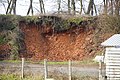
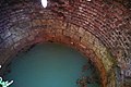
The two concessions in question engage exclusively in the exploitation of oil shale within the commune of Dracy-Saint-Loup, utilizing the techniques of room and pillar mining. The depth of the underground workings is approximately fifty meters. [8]
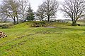
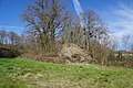
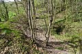
At the beginning of the 21st century, the slag heap of the plant and the flooded access trench of the Duverne incline remain in situ. [9]
- The Duverne incline
-
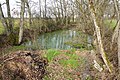 Flooded access trench.
 -
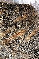
 Slag heap.
 -
 Detail.


This concession is for the exclusive extraction of oil shale in Curgy, using cross-cut galleries. The underground workings do not exceed a depth of 18 meters. [8]
At the beginning of the 21st century, some subsidence was still taking place at mine access. [9]
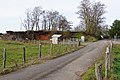
This concession is distinct from the others in that it exclusively mines coal in the commune of Tavernay using room and pillar mining and partial backfilling techniques. The underground workings reach an 82-meter depth, [8] with the coal pits located in Chambois, Saint-Romain (two pits), and Polroy. These pits were exploited in the 19th century.
At the beginning of the 21st century, the site was still characterized by the presence of slag heaps and a sunken pit. [9]
- Remains of the Chambois coal mines
-
 Shaft No. 5 between the two trunks.
 -
 The slag heap at shaft No. 5.
 -
 The Saint-Georges slag heap.
_-_12.jpg)
_-_23.jpg)
_-_07.jpg)
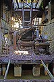
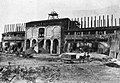
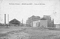
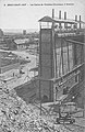
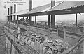
The concession for the extraction of oil shale was granted in 1865. The extraction is carried out exclusively in the commune of Saint-Forgeot using various methods, including room and pillar mining, longwall mining, and caving. The workings extend to a depth of approximately 100 meters. [8] In 1936, a refinery was constructed to complement the petroleum distillation plant, employing several hundred workers in the production of automotive fuel. [o 1] [i 2] During the Occupation, this site was of strategic importance to the German army, which monitored it. In response, the local resistance and the Allies (notably the Scullion raids) conducted minor sabotage acts. In retaliation, five workers were executed by the militia. [o 4]
-
 The headframe of an extraction shaft.
 -
 Shale preparation.
 -
 Crushing and stockpiling.
 -
 Overview.


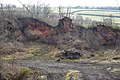
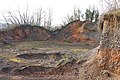
Following the site's closure in 1957, it was dismantled and partially demolished. At the beginning of the 21st century, the landscape was marked by the site remains, including ruins and two large slag heaps. [10] [i 2] [i 3] These had become overrun by distinctive vegetation, which has been studied for its biodiversity. The site is recognized as a natural area of ecological, faunistic, and floristic interest (ZNIEFF).
- The mining remnants of Télots
-
 Two slag heaps.
 -
 General aerial view.
 -
 Water tank.
 -
 Crusher.
 -
 Downhill machinery.


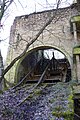
The Millery incline is linked to the workings of Télots via the tenth layer. At the beginning of the 21st century, the backfilled entrance and the windlass building were still visible. [i 2] [i 3]
- The Millery yard
-
 Windlass.
 -
 Overview.
 -
 Backfilled entrance.
 -
 The entrance with the Télots slag heaps in the background.


.jpg)
The concession employs diverse techniques to mine oil shale, including room and pillar mining, longwall mining, and isolated galleries. The depth of the workings is approximately 100 meters. [8]
At the beginning of the 21st century, the Saint-Georges pit still exhibited the slag heap and windlass building that had been constructed at the outset of the 20th century. [11]
- Mining remnants
-
 The Saint-Georges shaft windlass building.
 -
 Saint-Georges shaft slag heap.
 -
 Detail.
_-_06.jpg)
_-_01.jpg)
_-_02.jpg)
The concession mines oil shale by longwall mining and pillar removal in Saint-Léger-du-Bois, with underground workings reaching 75 meters in depth. [8]
At the beginning of the 21st century, the slag heap and the location of the Champsigny pit remain. [12]
- Mining remnants
-
 Champsigny shaft.
 -
 Champsigny shaft slag heap.
 -
 Overview of slag heap and shaft.


The concession in question mines oil shale in the commune of Tavernay using the room and pillar mining method. The depth of the underground workings is 80 meters. [8]
This concession mines oil shale through exploratory works, irregular galleries, and stripped or caved areas. [8] The Ravelon mine was one of the primary exploitations of the deposit in the 1870s; it was subsequently abandoned following the 1914 mobilization. The Muse and Miens plants were established in the 1870s and were highly active between 1883 and 1905.
In the early years of the 21st century, a number of galleries [12] and vestiges of the two original plants remained in situ.
These concessions mine oil shale in the commune of Tavernay using the room and pillar mining method, which is rarely stripped. The underground workings extend to a depth of 48 meters. [8] During the nineteenth century, Tavernay was home to five shale plants. These were situated in Poizot, Bois de La Revenue, Pont Renault, La Marbre, and a substantial facility close to La Comaille. This latter plant employed up to 110 workers and ceased operations permanently in 1903. Most mines and plants remained operational for a mere twenty to thirty years.
At the beginning of the 21st century, the landscape still bore witness to the presence of several abandoned slag heaps and mine pits. [13]
- Remnants of the oil shale mines of Bois Saint-Romain
-
 Esterno shaft.
 -
 Esterno shaft slag heap.
 -
 Guilloux shaft.
 -
 Guilloux shaft slag heap.


- Remnants of the oil shale mines of Comaille
-
 Sainte-Marie shaft.
 -
 Pré Renaud shaft.
 -
 The Pré Renaud slag heap.
 -
 Shaft No. III and its slag heap.
_-_02.jpg)


_-_04.jpg)
The concessions mine oil shale in the commune of Igornay using the room and pillar mining method. The underground workings extend to a depth of 60 meters. [8]
At the beginning of the 21st century, the Selligue pit, subsidence, and an open-pit mine remained in operation. [14]
This concession mines oil shale in the commune of Monthelon with longwall mining and backfilling. The underground workings reach a depth of 110 meters. [8]
At the beginning of the 21st century, the Castillion house, a worker's lodging, remains. [14]


This concession mines oil shale in the commune of Dracy-Saint-Loup using room and pillar mining techniques. The underground workings extend to a depth of 100 meters. [8] The Ravelon mine was one of the primary exploitations of the deposit during the 1870s; it was subsequently abandoned following the 1914 mobilization.
- Ravelon factory
-
 Factory and headframe in 1888.
 -
 After 1900.
 -
-


At the beginning of the 21st century, the slag heap of the plant and the outlet of the Vesvre incline remain in situ. [15]
- Ravelon slag heap
-
 Overview.
 -
-
 Rock detail.
 -
 Distant view.


The total estimated production of the deposit is 13 million tons of oil shale. [6]
In the early 1980s, studies conducted by Pascal Martaud for the BRGM revealed the existence of significant reserves, [16] estimated to be between 20 and 30 million tons. The deposit covers an area of 240 km². [o 2]
 Definitions from Wiktionary
 Media from Commons
 News from Wikinews
 Quotations from Wikiquote
 Texts from Wikisource
 Textbooks from Wikibooks
 Resources from Wikiversity
- Les Télots Mine
- Mining in France
- Oil reserves in France
- Unconventional (oil and gas) reservoir
- Shale oil
- Works in bibliography
- ^ a b Le Goff 2013a, p. 9
- ^ a b c Le Goff 2013a, p. 11
- ^ Gand 2010
- ^ a b Le Goff 2013a, p. 12
- ^ a b Feys 1945, pp. 16–17
- ^ a b c d e Le Goff 2013a, p. 17
- ^ Feys 1945, pp. 20–21
- ^ a b c d e f g h i j k l Le Goff 2013a, pp. 20–21
- ^ a b c Le Goff 2013d, p. 3 (Appendix 7)
- ^ Le Goff 2013d, p. 9 (Appendix 7)
- ^ Le Goff 2013d, p. 6 (Appendix 7)
- ^ a b Le Goff 2013d, p. 4 (Appendix 7)
- ^ Le Goff 2013d, pp. 5, 10 & 11 (Appendix 7)
- ^ a b Le Goff 2013d, p. 7 (Appendix 7)
- ^ Le Goff 2013d, p. 11 (Appendix 7)
- ^ Passaqui & Bellenfant 2010, p. 9
- Other works
- ^ a b c Lecomte, Bernard (2013). La Bourgogne Pour les Nuls (in French). Deux mystérieux terrils à l'entrée d'Autun. ISBN 978-2-7540-5487-4. Archived from the original on March 2, 2018.
- ^
a
b
c Miot, Gilles.
"L'exploitation de schiste bitumineux dans l'Autunois : La mine et l'usine des Télots" (PDF). Recherches des étudiants (in French). Archived from the original on January 3, 2022. Retrieved July 25, 2024.
{{
cite web}}
: CS1 maint: bot: original URL status unknown ( link) - ^ Taupenot, Lucien (2006). "Quand le pétrole autunois éclairait Paris, Lyon, Dijon, Strasbourg". Images de Saône-et-Loire (in French) (145): 2 & 3.
- ^ Foot, Michael R D; Crémieux-Brilhac, Jean-Louis (2013). Des anglais dans la résistance. Le SOE en France, 1940-1944 (in French). Tallandier. ISBN 979-1-02100-194-7. Archived from the original on November 11, 2018.
- Online works
- ^ a b c CCCA d'après Gilles Pacaud. "Quel avenir pour les schistes bitumineux ?". gensdumorvan.fr (in French). Archived from the original on 2019-03-31.
- ^
a
b
c
d
"Les Houillères de Blanzy en Bourgogne : Mine de schiste bitumineux des Télots - Autun / Saint-Forgeot". patrimoine-minier.fr (in French). Archived from the original on April 17, 2024. Retrieved July 25, 2024.
{{
cite web}}
: CS1 maint: bot: original URL status unknown ( link) - ^
a
b
c
d
"Les Houillères de Blanzy : Mine des Télots". exxplore.fr (in French). Archived from the original on November 26, 2015. Retrieved July 25, 2024.
{{
cite web}}
: CS1 maint: bot: original URL status unknown ( link) - ^ Bonnard, Lilian (October 14, 2013). "Gaz de schiste et si on rouvrait la mine d'Autun ?". miroir-mag.fr (in French). Archived from the original on 2017-05-30.
- Feys, R (1945).
Puits et sondage dans le bassin d'Autun et Epinac, des origines à nos jours (PDF) (in French).
BRGM. Archived from the original on April 12, 2023. Retrieved July 25, 2024.
{{
cite book}}
: CS1 maint: bot: original URL status unknown ( link) - Passaqui, Jean-Philippe; Chabard, Dominique (2007). Les routes de l'énergie : Epinac, Autun, Morvan (in French). Autun Natural History Museum.
- Passaqui, Jean-Philippe; Bellenfant, Sylvain (2010). Les Télots : une usine devenue friche industrielle aux portes d'Autun (PDF) (in French). Bourgogne-Nature. Archived from the original (PDF) on 2017-08-21.
- Gand, Georges (2010). Reprise de fouilles paléontologiques dans un gîte bourguignon célèbre : les « schistes bitumineux » de l'Autunien de Muse (Bassin d'Autun) : Bilan 2010 et perspectives (PDF) (in French). Bourgogne-Naturef. Archived from the original (PDF) on 2018-08-10.
- Le Goff, J (2013a). Etude des aléas miniers dans le bassin d'Autun, Bourgogne (71) (exploitations de houille, schistes bitumineux et fluorine) : Communes de Autun, Barnay, Cordesse, Curgy, Dracy-Saint-Loup, Igornay, La Celle en Morvan, Monthelon, La Grande Verrière, La Petite Verrière, Reclesne, Saint Forgeot, Saint Léger du Bois, Sully et Tavernay (in French). Vol. 1. Géoderis.
- Le Goff, J (2013b). Etude des aléas miniers dans le bassin d'Autun, Bourgogne (71) (exploitations de houille, schistes bitumineux et fluorine) : Communes de Autun, Barnay, Cordesse, Curgy, Dracy-Saint-Loup, Igornay, La Celle en Morvan, Monthelon, La Grande Verrière, La Petite Verrière, Reclesne, Saint Forgeot, Saint Léger du Bois, Sully et Tavernay (in French). Vol. 2. Géoderis.
- Le Goff, J (2013c). Etude des aléas miniers dans le bassin d'Autun, Bourgogne (71) (exploitations de houille, schistes bitumineux et fluorine) : Communes de Autun, Barnay, Cordesse, Curgy, Dracy-Saint-Loup, Igornay, La Celle en Morvan, Monthelon, La Grande Verrière, La Petite Verrière, Reclesne, Saint Forgeot, Saint Léger du Bois, Sully et Tavernay (in French). Vol. 3. Géoderis.
- Le Goff, J (2013d). Etude des aléas miniers dans le bassin d'Autun, Bourgogne (71) (exploitations de houille, schistes bitumineux et fluorine) : Communes de Autun, Barnay, Cordesse, Curgy, Dracy-Saint-Loup, Igornay, La Celle en Morvan, Monthelon, La Grande Verrière, La Petite Verrière, Reclesne, Saint Forgeot, Saint Léger du Bois, Sully et Tavernay (in French). Vol. 4. Géoderis.
-
"Histoire des mines de schiste". mairie-saint-forgeot.fr (in French). Archived from the original on April 18, 2021. Retrieved July 25, 2024.
{{
cite web}}
: CS1 maint: bot: original URL status unknown ( link)
| Review waiting, please be patient.
This may take 4 months or more, since drafts are reviewed in no specific order. There are 2,741 pending submissions waiting for review.
Where to get help
How to improve a draft
You can also browse Wikipedia:Featured articles and Wikipedia:Good articles to find examples of Wikipedia's best writing on topics similar to your proposed article. Improving your odds of a speedy review To improve your odds of a faster review, tag your draft with relevant WikiProject tags using the button below. This will let reviewers know a new draft has been submitted in their area of interest. For instance, if you wrote about a female astronomer, you would want to add the Biography, Astronomy, and Women scientists tags. Editor resources
Reviewer tools
|
The Autun oil shale deposit is a sedimentary basin containing oil shale of the Autunian age (between 299 and 282 million years old) in the vicinity of Autun in Saône-et-Loire, in the center-east of France.
The extraction of the shale commenced in 1824 at Igornay. Oil shale production began as early as 1837 for public lighting purposes, with facilities undergoing continuous improvement to diversify production. The largest of these facilities was the Télots mine, which was equipped with a refinery in 1936 and employed several hundred workers to produce automobile fuel. This mine was the last to close in 1957. The total production of the deposit is estimated at 13 million tons.
The vestiges of this industrial activity, in the form of ruins and slag heaps, persist in the early 21st century, particularly in the villages of Dracy-Saint-Loup, Saint-Forgeot, and Tavernay.
The deposit is situated in a valley in the Morvan, spanning the territories of the communes of Autun, Dracy-Saint-Loup, Igornay, Saint-Forgeot, Tavernay, and other neighboring communes in the north of the Saône-et-Loire department, in the Bourgogne-Franche-Comté region in the Grand Est of France. [1]
The sedimentary basin is an underground depression with an east-west orientation, measuring approximately 30 km in length and reaching a maximum width of 12 km. [1]
The Autun basin is in direct proximity to the Épinac coal basin. The two deposits have a significant degree of overlap and are even jointly exploited in the communes of Sully and Saint-Léger-du-Bois. [2]
The Autun oil shale deposit has lent its name to the geological period during which it was formed, the Autunian, which spans between -299 and -282 million years ago. [3] The deposit measures 1.3 km in thickness [2] and has never been fully traversed. The deepest shaft, La Brasserie, reaches a depth of 463 meters. [4] The oil shale layers are interspersed with fine detrital sediments, including limestone. The layers form lenses whose thickness and quality vary greatly. The deposit is based on the Stephanian coal foundation of Épinac. [2]
The basin is divided into two stratigraphic units, which are subdivided into two beds: [4]
- Lower Autunian:
- The Igornay bed is situated directly on the Moloy ( Saint-Léger-du-Bois) coal terrain. It has a thickness ranging from 150 to 230 meters, comprising alternating layers of bituminous and non-bituminous coal, overlain by a substantial sandstone layer.
- The Muse bed is 400 meters in thickness and includes bituminous layers, namely the Laly and Muse layers.
- Upper Autunian:
- The Surmoulin bed ( Dracy-Saint-Loup) has a thickness of 250 meters and comprises, in its lower portion, the extensive Surmoulin oil shale layer.
- The Millery bed ( Saint-Forgeot) is 250 meters in length and consists of shale intermingled with detrital rock. It contains ten layers of bitumen, which have been significantly mined at the Télots mine. The upper layer is composed of boghead, a type of bituminous coal.
The deposit was initially identified in 1813 at Igornay, and extraction commenced in 1824 within this commune. The industrial production of oil shale began in 1837 for public lighting in several major cities, including Paris, Lyon, Dijon, and Strasbourg. [5] [i 1] [o 1] [i 2] To extract the oil, the shale is crushed and then heated to a temperature between 450 and 500 °C in a confined, airless space. The escaping vapor is then condensed to obtain a liquid material similar to petroleum. [i 3] Despite facing competition from coal gas in 1847, the production of Autun lamp oil rebounded quickly. [o 2]
1864 and 1865 represented a period of peak profitability for shareholders, with a 30% return on investment. In 1865, approximately 6,700 tons of oil were extracted from oil shales, [o 3] utilizing approximately twenty extraction sites and sixteen processing plants. [6]
Towards the conclusion of the nineteenth century, shale was extracted at depths reaching 300 meters below the surface. The advent of competition from American and Russian oil in 1870 led to the demise of several concessions. In 1881, the Société Lyonnaise des Schistes Bitumineux (SLSB) purchased several remaining concessions to restart production with new private capital and state aid. This resulted in the company obtaining a monopoly in 1891. Surface installations were progressively completed from 1840 to 1870, particularly for the production of oil, paraffin, sulfates, and ammonia. However, the latter products were abandoned after World War I. [5] [i 1] [o 1] [o 2] [6] [i 4]
In 1892, the state implemented a reduction in customs duties on imported oils, thereby enhancing their competitive position vis-à-vis Autun oil shale. To offset this, premiums were introduced, enabling the modernization of installations and a 30% increase in crude oil yield. After the 1914 mobilization, the mines and factories of Ravelon ( Dracy-Saint-Loup) and Margenne ( Monthelon) were compelled to cease operations. The exploitation of the oil shale deposits was concentrated at the Télots and Surmoulin sites, in the Dracy-Saint-Loup region. In 1933, a legislative measure was enacted that granted tax exemption for fuels derived from oil shale, thereby opening up new avenues for exploration. The implementation of social reforms by the Popular Front in 1936 led to a reduction in the profitability of the SLSB. A new company, the Société Minière des Schistes Bitumineux (SMSB), was established with financial backing from Pechelbronn SAEM. The managers were committed to increasing production sixfold, to extract 3,000 tons of shale per day and distill 5,000 m³ of hydrocarbons per month. However, these goals were abandoned after Liberation was unattainable. During Reconstruction, mechanization was employed to maintain production at 300,000 tons of shale extracted per year, with yields superior to those of most coal mines. [6]
The cessation of activity at Télots was prompted by two key factors: the emergence of liquid petroleum as a more lucrative alternative [i 1] [i 3] and the termination of state subsidies. These developments led to the dissolution of the SMSB on December 11, 1958. [6]
| Name | Surface | Institution |
|---|---|---|
| Igornay | 522 | July 29, 1841 |
| Millery | 522 | July 11, 1843 |
| Surmoulin | 1068 | November 4, 1843 |
| Dracy-Saint-Loup | 398 | November 4, 1843 |
| Saint-Léger-du-Bois | 515 | February 14, 1846 |
| Comaille | 331 | August 31, 1845 |
| Petite-Chaume | 280 | July 25, 1855 |
| Poisot | 638 | December 17, 1856 |
| Chambois | 1130 | July 27, 1859 |
| Ruet | 810 | October 21, 1861 |
| Abots | 305 | May 8, 1862 |
| Chevigny | 304 | July 25, 1864 |
| Ravelon | 610 | August 1, 1864 |
| Lally | 278 | December 4, 1864 |
| Saint-Forgeot | 364 | February 18, 1865 |
| Télots | 518 | April 22, 1865 |
| Hauterive | 518 | August 20, 1865 |
| Margenne | 243 | February 6, 1877 |
| Curgy | 327 | ? |
| Champsigny | 113 | ? |
| Miens | 486 | ? |
The two concessions in question engage exclusively in the exploitation of oil shale within the commune of Dracy-Saint-Loup, utilizing the techniques of room and pillar mining. The depth of the underground workings is approximately fifty meters. [8]
At the beginning of the 21st century, the slag heap of the plant and the flooded access trench of the Duverne incline remain in situ. [9]
- The Duverne incline
-
Flooded access trench.
-
Slag heap.
-
Detail.
This concession is for the exclusive extraction of oil shale in Curgy, using cross-cut galleries. The underground workings do not exceed a depth of 18 meters. [8]
At the beginning of the 21st century, some subsidence was still taking place at mine access. [9]
This concession is distinct from the others in that it exclusively mines coal in the commune of Tavernay using room and pillar mining and partial backfilling techniques. The underground workings reach an 82-meter depth, [8] with the coal pits located in Chambois, Saint-Romain (two pits), and Polroy. These pits were exploited in the 19th century.
At the beginning of the 21st century, the site was still characterized by the presence of slag heaps and a sunken pit. [9]
- Remains of the Chambois coal mines
-
Shaft No. 5 between the two trunks.
-
The slag heap at shaft No. 5.
-
The Saint-Georges slag heap.
The concession for the extraction of oil shale was granted in 1865. The extraction is carried out exclusively in the commune of Saint-Forgeot using various methods, including room and pillar mining, longwall mining, and caving. The workings extend to a depth of approximately 100 meters. [8] In 1936, a refinery was constructed to complement the petroleum distillation plant, employing several hundred workers in the production of automotive fuel. [o 1] [i 2] During the Occupation, this site was of strategic importance to the German army, which monitored it. In response, the local resistance and the Allies (notably the Scullion raids) conducted minor sabotage acts. In retaliation, five workers were executed by the militia. [o 4]
-
The headframe of an extraction shaft.
-
Shale preparation.
-
Crushing and stockpiling.
-
Overview.
Following the site's closure in 1957, it was dismantled and partially demolished. At the beginning of the 21st century, the landscape was marked by the site remains, including ruins and two large slag heaps. [10] [i 2] [i 3] These had become overrun by distinctive vegetation, which has been studied for its biodiversity. The site is recognized as a natural area of ecological, faunistic, and floristic interest (ZNIEFF).
- The mining remnants of Télots
-
Two slag heaps.
-
General aerial view.
-
Water tank.
-
Crusher.
-
Downhill machinery.
The Millery incline is linked to the workings of Télots via the tenth layer. At the beginning of the 21st century, the backfilled entrance and the windlass building were still visible. [i 2] [i 3]
- The Millery yard
-
Windlass.
-
Overview.
-
Backfilled entrance.
-
The entrance with the Télots slag heaps in the background.
The concession employs diverse techniques to mine oil shale, including room and pillar mining, longwall mining, and isolated galleries. The depth of the workings is approximately 100 meters. [8]
At the beginning of the 21st century, the Saint-Georges pit still exhibited the slag heap and windlass building that had been constructed at the outset of the 20th century. [11]
- Mining remnants
-
The Saint-Georges shaft windlass building.
-
Saint-Georges shaft slag heap.
-
Detail.
The concession mines oil shale by longwall mining and pillar removal in Saint-Léger-du-Bois, with underground workings reaching 75 meters in depth. [8]
At the beginning of the 21st century, the slag heap and the location of the Champsigny pit remain. [12]
- Mining remnants
-
Champsigny shaft.
-
Champsigny shaft slag heap.
-
Overview of slag heap and shaft.
The concession in question mines oil shale in the commune of Tavernay using the room and pillar mining method. The depth of the underground workings is 80 meters. [8]
This concession mines oil shale through exploratory works, irregular galleries, and stripped or caved areas. [8] The Ravelon mine was one of the primary exploitations of the deposit in the 1870s; it was subsequently abandoned following the 1914 mobilization. The Muse and Miens plants were established in the 1870s and were highly active between 1883 and 1905.
In the early years of the 21st century, a number of galleries [12] and vestiges of the two original plants remained in situ.
These concessions mine oil shale in the commune of Tavernay using the room and pillar mining method, which is rarely stripped. The underground workings extend to a depth of 48 meters. [8] During the nineteenth century, Tavernay was home to five shale plants. These were situated in Poizot, Bois de La Revenue, Pont Renault, La Marbre, and a substantial facility close to La Comaille. This latter plant employed up to 110 workers and ceased operations permanently in 1903. Most mines and plants remained operational for a mere twenty to thirty years.
At the beginning of the 21st century, the landscape still bore witness to the presence of several abandoned slag heaps and mine pits. [13]
- Remnants of the oil shale mines of Bois Saint-Romain
-
Esterno shaft.
-
Esterno shaft slag heap.
-
Guilloux shaft.
-
Guilloux shaft slag heap.
- Remnants of the oil shale mines of Comaille
-
Sainte-Marie shaft.
-
Pré Renaud shaft.
-
The Pré Renaud slag heap.
-
Shaft No. III and its slag heap.
The concessions mine oil shale in the commune of Igornay using the room and pillar mining method. The underground workings extend to a depth of 60 meters. [8]
At the beginning of the 21st century, the Selligue pit, subsidence, and an open-pit mine remained in operation. [14]
This concession mines oil shale in the commune of Monthelon with longwall mining and backfilling. The underground workings reach a depth of 110 meters. [8]
At the beginning of the 21st century, the Castillion house, a worker's lodging, remains. [14]
This concession mines oil shale in the commune of Dracy-Saint-Loup using room and pillar mining techniques. The underground workings extend to a depth of 100 meters. [8] The Ravelon mine was one of the primary exploitations of the deposit during the 1870s; it was subsequently abandoned following the 1914 mobilization.
- Ravelon factory
-
Factory and headframe in 1888.
-
After 1900.
-
-
At the beginning of the 21st century, the slag heap of the plant and the outlet of the Vesvre incline remain in situ. [15]
- Ravelon slag heap
-
Overview.
-
-
Rock detail.
-
Distant view.
The total estimated production of the deposit is 13 million tons of oil shale. [6]
In the early 1980s, studies conducted by Pascal Martaud for the BRGM revealed the existence of significant reserves, [16] estimated to be between 20 and 30 million tons. The deposit covers an area of 240 km². [o 2]
-
Definitions from Wiktionary
-
Media from Commons
-
News from Wikinews
-
Quotations from Wikiquote
-
Texts from Wikisource
-
Textbooks from Wikibooks
-
Resources from Wikiversity
- Les Télots Mine
- Mining in France
- Oil reserves in France
- Unconventional (oil and gas) reservoir
- Shale oil
- Works in bibliography
- ^ a b Le Goff 2013a, p. 9
- ^ a b c Le Goff 2013a, p. 11
- ^ Gand 2010
- ^ a b Le Goff 2013a, p. 12
- ^ a b Feys 1945, pp. 16–17
- ^ a b c d e Le Goff 2013a, p. 17
- ^ Feys 1945, pp. 20–21
- ^ a b c d e f g h i j k l Le Goff 2013a, pp. 20–21
- ^ a b c Le Goff 2013d, p. 3 (Appendix 7)
- ^ Le Goff 2013d, p. 9 (Appendix 7)
- ^ Le Goff 2013d, p. 6 (Appendix 7)
- ^ a b Le Goff 2013d, p. 4 (Appendix 7)
- ^ Le Goff 2013d, pp. 5, 10 & 11 (Appendix 7)
- ^ a b Le Goff 2013d, p. 7 (Appendix 7)
- ^ Le Goff 2013d, p. 11 (Appendix 7)
- ^ Passaqui & Bellenfant 2010, p. 9
- Other works
- ^ a b c Lecomte, Bernard (2013). La Bourgogne Pour les Nuls (in French). Deux mystérieux terrils à l'entrée d'Autun. ISBN 978-2-7540-5487-4. Archived from the original on March 2, 2018.
- ^
a
b
c Miot, Gilles.
"L'exploitation de schiste bitumineux dans l'Autunois : La mine et l'usine des Télots" (PDF). Recherches des étudiants (in French). Archived from the original on January 3, 2022. Retrieved July 25, 2024.
{{
cite web}}
: CS1 maint: bot: original URL status unknown ( link) - ^ Taupenot, Lucien (2006). "Quand le pétrole autunois éclairait Paris, Lyon, Dijon, Strasbourg". Images de Saône-et-Loire (in French) (145): 2 & 3.
- ^ Foot, Michael R D; Crémieux-Brilhac, Jean-Louis (2013). Des anglais dans la résistance. Le SOE en France, 1940-1944 (in French). Tallandier. ISBN 979-1-02100-194-7. Archived from the original on November 11, 2018.
- Online works
- ^ a b c CCCA d'après Gilles Pacaud. "Quel avenir pour les schistes bitumineux ?". gensdumorvan.fr (in French). Archived from the original on 2019-03-31.
- ^
a
b
c
d
"Les Houillères de Blanzy en Bourgogne : Mine de schiste bitumineux des Télots - Autun / Saint-Forgeot". patrimoine-minier.fr (in French). Archived from the original on April 17, 2024. Retrieved July 25, 2024.
{{
cite web}}
: CS1 maint: bot: original URL status unknown ( link) - ^
a
b
c
d
"Les Houillères de Blanzy : Mine des Télots". exxplore.fr (in French). Archived from the original on November 26, 2015. Retrieved July 25, 2024.
{{
cite web}}
: CS1 maint: bot: original URL status unknown ( link) - ^ Bonnard, Lilian (October 14, 2013). "Gaz de schiste et si on rouvrait la mine d'Autun ?". miroir-mag.fr (in French). Archived from the original on 2017-05-30.
- Feys, R (1945).
Puits et sondage dans le bassin d'Autun et Epinac, des origines à nos jours (PDF) (in French).
BRGM. Archived from the original on April 12, 2023. Retrieved July 25, 2024.
{{
cite book}}
: CS1 maint: bot: original URL status unknown ( link) - Passaqui, Jean-Philippe; Chabard, Dominique (2007). Les routes de l'énergie : Epinac, Autun, Morvan (in French). Autun Natural History Museum.
- Passaqui, Jean-Philippe; Bellenfant, Sylvain (2010). Les Télots : une usine devenue friche industrielle aux portes d'Autun (PDF) (in French). Bourgogne-Nature. Archived from the original (PDF) on 2017-08-21.
- Gand, Georges (2010). Reprise de fouilles paléontologiques dans un gîte bourguignon célèbre : les « schistes bitumineux » de l'Autunien de Muse (Bassin d'Autun) : Bilan 2010 et perspectives (PDF) (in French). Bourgogne-Naturef. Archived from the original (PDF) on 2018-08-10.
- Le Goff, J (2013a). Etude des aléas miniers dans le bassin d'Autun, Bourgogne (71) (exploitations de houille, schistes bitumineux et fluorine) : Communes de Autun, Barnay, Cordesse, Curgy, Dracy-Saint-Loup, Igornay, La Celle en Morvan, Monthelon, La Grande Verrière, La Petite Verrière, Reclesne, Saint Forgeot, Saint Léger du Bois, Sully et Tavernay (in French). Vol. 1. Géoderis.
- Le Goff, J (2013b). Etude des aléas miniers dans le bassin d'Autun, Bourgogne (71) (exploitations de houille, schistes bitumineux et fluorine) : Communes de Autun, Barnay, Cordesse, Curgy, Dracy-Saint-Loup, Igornay, La Celle en Morvan, Monthelon, La Grande Verrière, La Petite Verrière, Reclesne, Saint Forgeot, Saint Léger du Bois, Sully et Tavernay (in French). Vol. 2. Géoderis.
- Le Goff, J (2013c). Etude des aléas miniers dans le bassin d'Autun, Bourgogne (71) (exploitations de houille, schistes bitumineux et fluorine) : Communes de Autun, Barnay, Cordesse, Curgy, Dracy-Saint-Loup, Igornay, La Celle en Morvan, Monthelon, La Grande Verrière, La Petite Verrière, Reclesne, Saint Forgeot, Saint Léger du Bois, Sully et Tavernay (in French). Vol. 3. Géoderis.
- Le Goff, J (2013d). Etude des aléas miniers dans le bassin d'Autun, Bourgogne (71) (exploitations de houille, schistes bitumineux et fluorine) : Communes de Autun, Barnay, Cordesse, Curgy, Dracy-Saint-Loup, Igornay, La Celle en Morvan, Monthelon, La Grande Verrière, La Petite Verrière, Reclesne, Saint Forgeot, Saint Léger du Bois, Sully et Tavernay (in French). Vol. 4. Géoderis.
-
"Histoire des mines de schiste". mairie-saint-forgeot.fr (in French). Archived from the original on April 18, 2021. Retrieved July 25, 2024.
{{
cite web}}
: CS1 maint: bot: original URL status unknown ( link)