Dolenja Podgora | |
|---|---|
| Coordinates: 45°31′51.24″N 15°4′25.41″E / 45.5309000°N 15.0737250°E | |
| Country |
|
| Traditional region | White Carniola |
| Statistical region | Southeast Slovenia |
| Municipality | Črnomelj |
| Area | |
| • Total | 5.68 km2 (2.19 sq mi) |
| Elevation | 393.2 m (1,290.0 ft) |
| Population (2020) | |
| • Total | 7 |
| • Density | 1.2/km2 (3.2/sq mi) |
| [1] | |
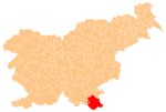
Dolenja Podgora (pronounced [dɔˈleːnja pɔdˈɡɔːɾa]; German: Unterberg [2]) is a settlement in the hills southwest of Črnomelj in the White Carniola area of southeastern Slovenia. The area is part of the traditional region of Lower Carniola and is now included in the Southeast Slovenia Statistical Region. [3]
A site of an Eneolithic settlement with evidence of occupation also in Late Antiquity has been found in the Židovec area near the village. [4]
References
- ^ Statistical Office of the Republic of Slovenia
- ^ Leksikon občin kraljestev in dežel zastopanih v državnem zboru, vol. 6: Kranjsko. 1906. Vienna: C. Kr. Dvorna in Državna Tiskarna, p. 4.
- ^ Črnomelj municipal site
- ^ Slovenian Ministry of Culture register of national heritage reference number ešd 19755
External links

