Photos • Location

(Redirected from
Dogwood, Graves County, Kentucky)
Dogwood, Graves County, Kentucky | |
|---|---|
 Dogwood  Dogwood | |
| Coordinates: 36°53′03″N 88°34′33″W / 36.88417°N 88.57583°W | |
| Country | United States |
| State | Kentucky |
| County | Graves |
| Elevation | 381 ft (116 m) |
| Time zone | UTC-6 ( Central (CST)) |
| • Summer ( DST) | UTC-5 (CDT) |
Dogwood is an unincorporated community in Graves County, Kentucky, United States.
References
- "Dogwood, Kentucky". Geographic Names Information System. United States Geological Survey, United States Department of the Interior. Retrieved June 13, 2012.
Municipalities and communities of
Graves County, Kentucky, United States | ||
|---|---|---|
| Cities | 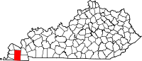 | |
| CDPs | ||
|
Unincorporated communities | ||
| Footnotes | ‡This populated place also has portions in an adjacent county or counties | |
|
| This Graves County, Kentucky state location article is a stub. You can help Wikipedia by expanding it. |
(Redirected from
Dogwood, Graves County, Kentucky)
Dogwood, Graves County, Kentucky | |
|---|---|
Dogwood Dogwood | |
| Coordinates: 36°53′03″N 88°34′33″W / 36.88417°N 88.57583°W | |
| Country | United States |
| State | Kentucky |
| County | Graves |
| Elevation | 381 ft (116 m) |
| Time zone | UTC-6 ( Central (CST)) |
| • Summer ( DST) | UTC-5 (CDT) |
Dogwood is an unincorporated community in Graves County, Kentucky, United States.
References
- "Dogwood, Kentucky". Geographic Names Information System. United States Geological Survey, United States Department of the Interior. Retrieved June 13, 2012.
Municipalities and communities of
Graves County, Kentucky, United States | ||
|---|---|---|
| Cities | | |
| CDPs | ||
|
Unincorporated communities | ||
| Footnotes | ‡This populated place also has portions in an adjacent county or counties | |
|
| This Graves County, Kentucky state location article is a stub. You can help Wikipedia by expanding it. |