Photos • Location


Dobřejovice | |
|---|---|
 Municipal office | |
 Flag  Coat of arms | |
 Dobřejovice Location in the Czech Republic | |
| Coordinates: 49°58′54″N 14°34′42″E / 49.98167°N 14.57833°E | |
| Country | |
| Region | Central Bohemian |
| District | Prague-East |
| First mentioned | 1309 |
| Area | |
| • Total | 3.85 km2 (1.49 sq mi) |
| Elevation | 328 m (1,076 ft) |
| Population (2023-01-01)
[1] | |
| • Total | 1,303 |
| • Density | 340/km2 (880/sq mi) |
| Time zone | UTC+1 ( CET) |
| • Summer ( DST) | UTC+2 ( CEST) |
| Postal code | 251 70 |
| Website |
www |
Dobřejovice is a municipality and village in Prague-East District in the Central Bohemian Region of the Czech Republic. It has about 1,300 inhabitants.
Demographics
| Year | Pop. | ±% |
|---|---|---|
| 1869 | 406 | — |
| 1880 | 445 | +9.6% |
| 1890 | 439 | −1.3% |
| 1900 | 404 | −8.0% |
| 1910 | 439 | +8.7% |
| 1921 | 412 | −6.2% |
| 1930 | 400 | −2.9% |
| 1950 | 331 | −17.2% |
| 1961 | 324 | −2.1% |
| 1970 | 276 | −14.8% |
| 1980 | 340 | +23.2% |
| 1991 | 425 | +25.0% |
| 2001 | 567 | +33.4% |
| 2011 | 1,025 | +80.8% |
| 2021 | 1,235 | +20.5% |
| Source: Censuses [2] [3] | ||
Notable people
- Václav Vačkář (1881–1954), composer and conductor
Gallery
-
 Common in Dobřejovice
 -
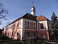 Dobřejovice Castle
 -
 U Potoka street

_-_z%C3%A1mek_(5).jpg)

References
- ^ "Population of Municipalities – 1 January 2023". Czech Statistical Office. 2023-05-23.
- ^ "Historický lexikon obcí České republiky 1869–2011 – Okres Praha-východ" (in Czech). Czech Statistical Office. 2015-12-21. pp. 3–4.
- ^ "Population Census 2021: Population by sex". Public Database. Czech Statistical Office. 2021-03-27.
External links
Wikimedia Commons has media related to
Dobřejovice.
| Authority control databases: National |
|---|
Dobřejovice | |
|---|---|
|
Municipal office | |
|
Flag Coat of arms | |
Dobřejovice Location in the Czech Republic | |
| Coordinates: 49°58′54″N 14°34′42″E / 49.98167°N 14.57833°E | |
| Country | |
| Region | Central Bohemian |
| District | Prague-East |
| First mentioned | 1309 |
| Area | |
| • Total | 3.85 km2 (1.49 sq mi) |
| Elevation | 328 m (1,076 ft) |
| Population (2023-01-01)
[1] | |
| • Total | 1,303 |
| • Density | 340/km2 (880/sq mi) |
| Time zone | UTC+1 ( CET) |
| • Summer ( DST) | UTC+2 ( CEST) |
| Postal code | 251 70 |
| Website |
www |
Dobřejovice is a municipality and village in Prague-East District in the Central Bohemian Region of the Czech Republic. It has about 1,300 inhabitants.
Demographics
| Year | Pop. | ±% |
|---|---|---|
| 1869 | 406 | — |
| 1880 | 445 | +9.6% |
| 1890 | 439 | −1.3% |
| 1900 | 404 | −8.0% |
| 1910 | 439 | +8.7% |
| 1921 | 412 | −6.2% |
| 1930 | 400 | −2.9% |
| 1950 | 331 | −17.2% |
| 1961 | 324 | −2.1% |
| 1970 | 276 | −14.8% |
| 1980 | 340 | +23.2% |
| 1991 | 425 | +25.0% |
| 2001 | 567 | +33.4% |
| 2011 | 1,025 | +80.8% |
| 2021 | 1,235 | +20.5% |
| Source: Censuses [2] [3] | ||
Notable people
- Václav Vačkář (1881–1954), composer and conductor
Gallery
-
Common in Dobřejovice
-
Dobřejovice Castle
-
U Potoka street
References
- ^ "Population of Municipalities – 1 January 2023". Czech Statistical Office. 2023-05-23.
- ^ "Historický lexikon obcí České republiky 1869–2011 – Okres Praha-východ" (in Czech). Czech Statistical Office. 2015-12-21. pp. 3–4.
- ^ "Population Census 2021: Population by sex". Public Database. Czech Statistical Office. 2021-03-27.
External links
Wikimedia Commons has media related to
Dobřejovice.
| Authority control databases: National |
|---|