Jdiouia
جديوية | |
|---|---|
Commune and town | |
 | |
| Country | |
| Province | Relizane Province |
| Time zone | UTC+1 ( CET) |
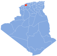
Djediouia or جديوية is a town and commune located at 35°5'46 " north, 0°49'50" east in Relizane Province, Algeria and the presumed site of Ancient city and bishopric Catabum Castra, now a Latin Catholic titular see.. [1] by 2008 this had risen to 33,835 and a population density of 254 inhabitants/km2. [2]
History
The Roman town Catabum Castra was important enough in the Roman province of Mauretania Caesariensis to become a suffragan bishopric of its capital Caesarea in Mauretania's Metropolitan Archbishop. Under the French it was known as Saint Aimé.
References
Source and External links
35°56′N 0°50′E / 35.933°N 0.833°E
Jdiouia
جديوية | |
|---|---|
Commune and town | |
 | |
| Country | |
| Province | Relizane Province |
| Time zone | UTC+1 ( CET) |
Djediouia or جديوية is a town and commune located at 35°5'46 " north, 0°49'50" east in Relizane Province, Algeria and the presumed site of Ancient city and bishopric Catabum Castra, now a Latin Catholic titular see.. [1] by 2008 this had risen to 33,835 and a population density of 254 inhabitants/km2. [2]
History
The Roman town Catabum Castra was important enough in the Roman province of Mauretania Caesariensis to become a suffragan bishopric of its capital Caesarea in Mauretania's Metropolitan Archbishop. Under the French it was known as Saint Aimé.
References
Source and External links
35°56′N 0°50′E / 35.933°N 0.833°E
