Photos • Location
40°57′32″N 45°12′07″E / 40.95889°N 45.20194°E
Ditavan
Դիտավան | |
|---|---|
| Coordinates: 40°57′32″N 45°12′07″E / 40.95889°N 45.20194°E | |
| Country | Armenia |
| Province | Tavush |
| Municipality | Ijevan |
| Elevation | 770 m (2,530 ft) |
| Population | |
| • Total | 348 |
| Time zone | UTC+4 ( AMT) |
| Ditavan at GEOnet Names Server | |
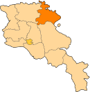
Ditavan ( Armenian: Դիտավան) is a village in the Ijevan Municipality of the Tavush Province of Armenia.
Toponymy
The village was previously located within the former Ijevan District and was known as Revazlu or Revaz. It was renamed Ditavan on May 25, 1967. [2]
References
- ^ Statistical Committee of Armenia. "The results of the 2011 Population Census of Armenia" (PDF).
- ^ Ադամյան, Կ. Ն. (1988). Հաեկական ՍՍՀ վարչատերիտորիալ բաժանումը: Առ 1-ը օգոստոսի 1988 թ. [The administrative-territorial division of the Armenian SSR. On August 1, 1988] (in Armenian). Երևան: «Հայաստան» հրատարակչություն. p. 98. ISBN 5-540-00698-4.
External links
40°57′32″N 45°12′07″E / 40.95889°N 45.20194°E
Ditavan
Դիտավան | |
|---|---|
| Coordinates: 40°57′32″N 45°12′07″E / 40.95889°N 45.20194°E | |
| Country | Armenia |
| Province | Tavush |
| Municipality | Ijevan |
| Elevation | 770 m (2,530 ft) |
| Population | |
| • Total | 348 |
| Time zone | UTC+4 ( AMT) |
| Ditavan at GEOnet Names Server | |
Ditavan ( Armenian: Դիտավան) is a village in the Ijevan Municipality of the Tavush Province of Armenia.
Toponymy
The village was previously located within the former Ijevan District and was known as Revazlu or Revaz. It was renamed Ditavan on May 25, 1967. [2]
References
- ^ Statistical Committee of Armenia. "The results of the 2011 Population Census of Armenia" (PDF).
- ^ Ադամյան, Կ. Ն. (1988). Հաեկական ՍՍՀ վարչատերիտորիալ բաժանումը: Առ 1-ը օգոստոսի 1988 թ. [The administrative-territorial division of the Armenian SSR. On August 1, 1988] (in Armenian). Երևան: «Հայաստան» հրատարակչություն. p. 98. ISBN 5-540-00698-4.


