Photos • Location
Dhadar
دھادر | |
|---|---|
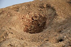
 Well at Mehrgarh Archaeological site | |
| Coordinates: 29°28′N 67°39′E / 29.47°N 67.65°E | |
| Country | Pakistan |
| Province | Balochistan |
| District | Kachhi District |
| Tehsil | Dhadar Tehsil |
| Elevation | 132 m (433 ft) |
| Time zone | UTC+5 ( PST) |
Dhadar ( Urdu: دھادر), also spelt Dadhar, is a town that serves as the headquarters of Kachhi District in the Balochistan province of Pakistan. [1] The town, which consists of one Union Council, is also the headquarters of the tehsil of the same name. [2] It is located at 29°28'0"N 67°39'0"E and has an altitude of 132 metres (436 feet). [3]
References
Dhadar
دھادر | |
|---|---|
 Well at Mehrgarh Archaeological site | |
| Coordinates: 29°28′N 67°39′E / 29.47°N 67.65°E | |
| Country | Pakistan |
| Province | Balochistan |
| District | Kachhi District |
| Tehsil | Dhadar Tehsil |
| Elevation | 132 m (433 ft) |
| Time zone | UTC+5 ( PST) |
Dhadar ( Urdu: دھادر), also spelt Dadhar, is a town that serves as the headquarters of Kachhi District in the Balochistan province of Pakistan. [1] The town, which consists of one Union Council, is also the headquarters of the tehsil of the same name. [2] It is located at 29°28'0"N 67°39'0"E and has an altitude of 132 metres (436 feet). [3]
References
