Dawei Airport | |||||||||||
|---|---|---|---|---|---|---|---|---|---|---|---|
 | |||||||||||
| Summary | |||||||||||
| Airport type | Public | ||||||||||
| Operator | Government | ||||||||||
| Serves | Dawei, Myanmar | ||||||||||
| Elevation AMSL | 84 ft / 26 m | ||||||||||
| Coordinates | 14°06′13″N 098°12′13″E / 14.10361°N 98.20361°E | ||||||||||
| Map | |||||||||||
| Runways | |||||||||||
| |||||||||||
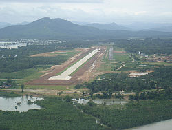
Dawei Airport ( IATA: TVY, ICAO: VYDW) is an airport serving Dawei [1] (formerly known as Tavoy), a city in the Tanintharyi Division in southeastern Myanmar. The airport is located in the northeastern part of the town, running from north to south.
The airport is at an elevation of 84 feet (26 m) above mean sea level. It has one runway designated 16/34 with a concrete surface measuring 3,661.5 by 30 metres (12,013 ft × 98 ft). [1]
| Airlines | Destinations |
|---|---|
| Air Thanlwin | Yangon |
| Mann Yadanarpon Airlines | Yangon [3] |
| Mingalar Aviation Services | Kawthaung, Yangon |
| Myanmar National Airlines | Kawthaung, [4] Yangon |
- ^ a b c Airport information for VYDW [usurped] from DAFIF (effective October 2006)
- ^ Airport information for TVY at Great Circle Mapper. Source: DAFIF (effective October 2006).
- ^ "Mann Yadanarpon Airlines flight 7Y533". Flightradar24.
- ^ "Myanmar National Airlines flight UB315". Flightradar24.
Dawei Airport | |||||||||||
|---|---|---|---|---|---|---|---|---|---|---|---|
 | |||||||||||
| Summary | |||||||||||
| Airport type | Public | ||||||||||
| Operator | Government | ||||||||||
| Serves | Dawei, Myanmar | ||||||||||
| Elevation AMSL | 84 ft / 26 m | ||||||||||
| Coordinates | 14°06′13″N 098°12′13″E / 14.10361°N 98.20361°E | ||||||||||
| Map | |||||||||||
| Runways | |||||||||||
| |||||||||||
Dawei Airport ( IATA: TVY, ICAO: VYDW) is an airport serving Dawei [1] (formerly known as Tavoy), a city in the Tanintharyi Division in southeastern Myanmar. The airport is located in the northeastern part of the town, running from north to south.
The airport is at an elevation of 84 feet (26 m) above mean sea level. It has one runway designated 16/34 with a concrete surface measuring 3,661.5 by 30 metres (12,013 ft × 98 ft). [1]
| Airlines | Destinations |
|---|---|
| Air Thanlwin | Yangon |
| Mann Yadanarpon Airlines | Yangon [3] |
| Mingalar Aviation Services | Kawthaung, Yangon |
| Myanmar National Airlines | Kawthaung, [4] Yangon |
- ^ a b c Airport information for VYDW [usurped] from DAFIF (effective October 2006)
- ^ Airport information for TVY at Great Circle Mapper. Source: DAFIF (effective October 2006).
- ^ "Mann Yadanarpon Airlines flight 7Y533". Flightradar24.
- ^ "Myanmar National Airlines flight UB315". Flightradar24.
