Davarzan County
Persian: شهرستان داورزن | |
|---|---|
 Location of Davarzan County in Razavi Khorasan Province (left, yellow) | |
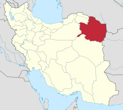
 Location of Razavi Khorasan Province in Iran | |
| Coordinates: 36°18′12″N 57°05′36″E / 36.30333°N 57.09333°E [1] | |
| Country | Iran |
| Province | Razavi Khorasan |
| Capital | Davarzan |
| Districts | Central, Bashtin |
| Area | |
| • Total | 2,420 km2 (930 sq mi) |
| Population (2016)
[2] | |
| • Total | 21,911 |
| • Density | 9.1/km2 (23/sq mi) |
| Time zone | UTC+3:30 ( IRST) |
Davarzan County ( Persian: شهرستان داورزن) is in Razavi Khorasan province, Iran. Its capital is the city of Davarzan. [3]
History
After the 2011 National Census, Davarzan District was separated from Sabzevar County in the establishment of Davarzan County, which was divided into two districts of two rural districts each, with the city of Davarzan as its capital and only city. [3]
Demographics
Population
At the time of the 2016 National Census, the county's population was 21,911 in 7,678 households. [2]
Administrative divisions
Davarzan County's population and administrative structure are shown in the following table.
| Administrative Divisions | 2016 [2] |
|---|---|
| Central District | 11,947 |
| Kah RD | 3,771 |
| Mazinan RD | 5,432 |
| Davarzan (city) | 2,744 |
| Bashtin District | 9,964 |
| Bashtin RD | 4,291 |
| Mehr RD | 5,673 |
| Total | 21,911 |
| RD = Rural District | |
See also
![]() Media related to
Davarzan County at Wikimedia Commons
Media related to
Davarzan County at Wikimedia Commons
References
- ^ OpenStreetMap contributors (28 April 2023). "Davarzan County" (Map). OpenStreetMap. Retrieved 28 April 2023.
- ^ a b c "Census of the Islamic Republic of Iran, 1395 (2016)". AMAR (in Persian). The Statistical Center of Iran. p. 09. Archived from the original (Excel) on 2 April 2022. Retrieved 19 December 2022.
- ^ a b Rahimi, Mohammadreza (30 June 2012). "Davarzan County was added to the map of country divisions". Iranian Students' News Agency (in Persian). Ministry of Interior, Council of Ministers. Archived from the original on 14 November 2023. Retrieved 14 November 2023.
Davarzan County
Persian: شهرستان داورزن | |
|---|---|
 Location of Davarzan County in Razavi Khorasan Province (left, yellow) | |
 Location of Razavi Khorasan Province in Iran | |
| Coordinates: 36°18′12″N 57°05′36″E / 36.30333°N 57.09333°E [1] | |
| Country | Iran |
| Province | Razavi Khorasan |
| Capital | Davarzan |
| Districts | Central, Bashtin |
| Area | |
| • Total | 2,420 km2 (930 sq mi) |
| Population (2016)
[2] | |
| • Total | 21,911 |
| • Density | 9.1/km2 (23/sq mi) |
| Time zone | UTC+3:30 ( IRST) |
Davarzan County ( Persian: شهرستان داورزن) is in Razavi Khorasan province, Iran. Its capital is the city of Davarzan. [3]
History
After the 2011 National Census, Davarzan District was separated from Sabzevar County in the establishment of Davarzan County, which was divided into two districts of two rural districts each, with the city of Davarzan as its capital and only city. [3]
Demographics
Population
At the time of the 2016 National Census, the county's population was 21,911 in 7,678 households. [2]
Administrative divisions
Davarzan County's population and administrative structure are shown in the following table.
| Administrative Divisions | 2016 [2] |
|---|---|
| Central District | 11,947 |
| Kah RD | 3,771 |
| Mazinan RD | 5,432 |
| Davarzan (city) | 2,744 |
| Bashtin District | 9,964 |
| Bashtin RD | 4,291 |
| Mehr RD | 5,673 |
| Total | 21,911 |
| RD = Rural District | |
See also
![]() Media related to
Davarzan County at Wikimedia Commons
Media related to
Davarzan County at Wikimedia Commons
References
- ^ OpenStreetMap contributors (28 April 2023). "Davarzan County" (Map). OpenStreetMap. Retrieved 28 April 2023.
- ^ a b c "Census of the Islamic Republic of Iran, 1395 (2016)". AMAR (in Persian). The Statistical Center of Iran. p. 09. Archived from the original (Excel) on 2 April 2022. Retrieved 19 December 2022.
- ^ a b Rahimi, Mohammadreza (30 June 2012). "Davarzan County was added to the map of country divisions". Iranian Students' News Agency (in Persian). Ministry of Interior, Council of Ministers. Archived from the original on 14 November 2023. Retrieved 14 November 2023.
