39°18′54″N 46°36′09″E / 39.31500°N 46.60250°E
Dəmirçilər | |
|---|---|
 Ruined state of the village following Armenian occupation | |
 Dəmirçilər | |
| Coordinates: 39°18′54″N 46°36′09″E / 39.31500°N 46.60250°E | |
| Country | |
| District | Qubadli |
| Time zone | UTC+4 ( AZT) |
Dəmirçilər (Damirchilar) is a village in the Qubadli District of Azerbaijan. It's located between the two rivers of Bargushad and Aghachay.
History
The origin of this village's name comes from Turkish tribes which subsisted in this region over a period of history.
It was captured by Armenian troops in August 1993 during First Nagorno-Karabakh War and was renamed Yerkatavork ( Armenian: Երկաթավորք). It was subsequently made part of the Kashatagh Province of self-proclaimed Republic of Artsakh. [1] It was captured by Azerbaijan Army on 7 November 2020 during the Lachin offensive.
Gallery
-
 Nature around the village
 -
 Nature around the village
 -
 Sign at the entrance of Damirchilar
 -
 Ruined state of the Damirchilar village in the Qubadli District of Azerbaijan
 -
 Ruined memorial spring in the village
 -
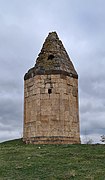 Back side of a Mausoleum near the village
 -
 Front of a Mausoleum near the village
 -
 View of ruined state of Damirchilar village
 -
 Ruined homes in the village
 -
 Destroyed house in the village
 -
 Ruined homes in the village


References
External links

|
| This Qubadli Rayon location article is a stub. You can help Wikipedia by expanding it. |
39°18′54″N 46°36′09″E / 39.31500°N 46.60250°E
Dəmirçilər | |
|---|---|
|
Ruined state of the village following Armenian occupation | |
Dəmirçilər | |
| Coordinates: 39°18′54″N 46°36′09″E / 39.31500°N 46.60250°E | |
| Country | |
| District | Qubadli |
| Time zone | UTC+4 ( AZT) |
Dəmirçilər (Damirchilar) is a village in the Qubadli District of Azerbaijan. It's located between the two rivers of Bargushad and Aghachay.
History
The origin of this village's name comes from Turkish tribes which subsisted in this region over a period of history.
It was captured by Armenian troops in August 1993 during First Nagorno-Karabakh War and was renamed Yerkatavork ( Armenian: Երկաթավորք). It was subsequently made part of the Kashatagh Province of self-proclaimed Republic of Artsakh. [1] It was captured by Azerbaijan Army on 7 November 2020 during the Lachin offensive.
Gallery
-
Nature around the village
-
Nature around the village
-
Sign at the entrance of Damirchilar
-
Ruined state of the Damirchilar village in the Qubadli District of Azerbaijan
-
Ruined memorial spring in the village
-
Back side of a Mausoleum near the village
-
Front of a Mausoleum near the village
-
View of ruined state of Damirchilar village
-
Ruined homes in the village
-
Destroyed house in the village
-
Ruined homes in the village
References
External links
|
| This Qubadli Rayon location article is a stub. You can help Wikipedia by expanding it. |