Photos • Location
| Creag Ghuanach | |
|---|---|
 Creag Ghuanach | |
| Highest point | |
| Elevation | 621 m (2,037 ft) [1] |
| Prominence | 212 m (696 ft) |
| Listing | Graham, Marilyn |
| Geography | |
| Location | Lochaber, Scotland |
| Parent range | Grampian Mountains |
| OS grid | NN299690 |
| Topo map | OS Landranger 41 |
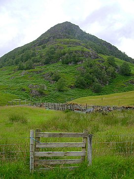
Creag Ghuanach (621 m) is a mountain in the Grampian Mountains of Scotland. It is located in Lochaber, at the southern head of Loch Treig.
A small but very craggy peak, Creag Ghuanach rises steeply from the Loch below. The nearest village is Roybridge several miles to the north. [2]
References
- ^ "Creag Ghuanach". hill-bagging.co.uk. Retrieved 6 June 2019.
- ^ "walkhighlands Creag Ghuanach". walkhighlands.co.uk. Retrieved 6 June 2019.
56°46′52″N 4°47′02″W / 56.7812°N 4.784°W
| Creag Ghuanach | |
|---|---|
 Creag Ghuanach | |
| Highest point | |
| Elevation | 621 m (2,037 ft) [1] |
| Prominence | 212 m (696 ft) |
| Listing | Graham, Marilyn |
| Geography | |
| Location | Lochaber, Scotland |
| Parent range | Grampian Mountains |
| OS grid | NN299690 |
| Topo map | OS Landranger 41 |
Creag Ghuanach (621 m) is a mountain in the Grampian Mountains of Scotland. It is located in Lochaber, at the southern head of Loch Treig.
A small but very craggy peak, Creag Ghuanach rises steeply from the Loch below. The nearest village is Roybridge several miles to the north. [2]
References
- ^ "Creag Ghuanach". hill-bagging.co.uk. Retrieved 6 June 2019.
- ^ "walkhighlands Creag Ghuanach". walkhighlands.co.uk. Retrieved 6 June 2019.
56°46′52″N 4°47′02″W / 56.7812°N 4.784°W