Photos • Location
Coro Coro Municipality | |
|---|---|
Municipality | |
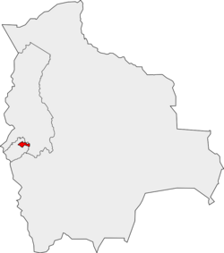
 Location of the Coro Coro Municipality within Bolivia | |
| Coordinates: 17°10′0″S 68°25′0″W / 17.16667°S 68.41667°W | |
| Country |
|
| Department | La Paz Department |
| Province | Pacajes Province |
| Seat | Coro Coro |
| Government | |
| • Mayor | Simeon Paredes Salluco (2007) |
| • President | Brito Choque Mollo (2007) |
| Area | |
| • Total | 421 sq mi (1,091 km2) |
| Elevation | 13,000 ft (4,000 m) |
| Population (2012) | |
| • Total | 10,647 |
| Time zone | UTC-4 (BOT) |
Coro Coro Municipality is the first municipal section of the Pacajes Province in the La Paz Department, Bolivia. Its seat is Coro Coro.
See also
References
External links
Coro Coro Municipality | |
|---|---|
Municipality | |
 Location of the Coro Coro Municipality within Bolivia | |
| Coordinates: 17°10′0″S 68°25′0″W / 17.16667°S 68.41667°W | |
| Country |
|
| Department | La Paz Department |
| Province | Pacajes Province |
| Seat | Coro Coro |
| Government | |
| • Mayor | Simeon Paredes Salluco (2007) |
| • President | Brito Choque Mollo (2007) |
| Area | |
| • Total | 421 sq mi (1,091 km2) |
| Elevation | 13,000 ft (4,000 m) |
| Population (2012) | |
| • Total | 10,647 |
| Time zone | UTC-4 (BOT) |
Coro Coro Municipality is the first municipal section of the Pacajes Province in the La Paz Department, Bolivia. Its seat is Coro Coro.
