Map of the inscriptions, 1887. The number 1-9 are Egyptian inscriptions (square numbers) and Assyrian (circled numbers). The Babylonian inscriptions is on the north bank (small oval sign) and on the western road is the Roman inscription (the letter S and small arrow).
The inscriptions are carved on a strategic location commanding the North-South coastal road along the
Eastern Mediterranean.[9] The earliest inscription is that of
Ramesses II, and relates to the
New Kingdom of Egypt's control of the region.[1] The earliest Egyptian incursions into the region were many centuries earlier, as recorded by the
Autobiography of Weni (c. 2280 BC)[10] and the
Sebek-khu Stele (c. 1860 BC).[11]
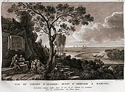
The earliest European to identify the site was the 17th-century traveller
Henry Maundrell in 1697,[6][7] who wrote of the river crossing:[12]
To accommodate the passage, you have a path of above two yards breadth cut along its side, at a great height above the water; being the work of the emperor Antoninus... The memory of which good work is perpetuated by an inscription, engraven on a table plained in the side of the natural rock, not far from the entrance into the way... In passing this way, we observed, in the sides of the rock above us, several tables of figures carved; which seemed to promise something of antiquity... as if the old way had gone in that region, before Antoninus cut the other more convenient passage a little lower. In several places hereabouts, we saw strange antique figures of men, carved in the natural rock, and in bigness equal to the life. Close by each figure was a large table, plained in the side of the rock, and bordered round with mouldings. Both the effigies and the tables appeared to have been anciently inscribed all over: but the characters are now so defaced, that nothing but the footsteps of them were visible; only there was one of the figures that had both its lineaments and its inscriptions entire.
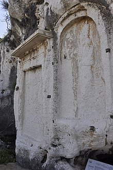
Inscriptions
Top row: The area of the inscriptions, with the highway tunnel and the entrance road Bottom row: Tourist signs describing the area, with the Zouk Mosbeh statue of Christ the King
Egyptian inscriptions
Three
Egyptian hieroglyphic inscriptions are known,[1] all of which bear the
cartouche of
Ramses II. This was first identified by
Karl Richard Lepsius.[13] At least one of these is thought to have been placed during the Pharaoh's first campaign in the Levant, and set the
Nahr al-Kalb as the border between
Egypt's province of
Canaan and the possessions of the
Hittites. However, the inscription is so weathered that only the name
Ramesses II and the date "year 4" can be read.[14]
Scholars such as
Edward Robinson connected the Ramses II inscriptions to
Sesostris, the Egyptian Pharaoh mentioned by
Herodotus,[13] in reference to Herodotus's note that "The pillars which Sesostris of Egypt set up in the various countries are for the most part no longer to be seen extant; but in Syria Palestine I myself saw them existing with the inscription upon them which I have mentioned and the emblem."[15]
Six
cuneiform Neo-Assyrian and Neo-Babylonian inscriptions are known.[1] The Esarhaddon stele refers to
Esarhaddon's seizure of
Memphis from Egyptian Pharaoh
Taharqa in 671 BC. The passage is badly damaged, but is understood to include reference to the cities of
Ashkelon and
Tyre, as well as
Taharqa and 22
vassal kings.[18] One inscription is attributed to
Nebuchadnezzar II.[19]
A number of
Greco-Roman inscriptions were carved at the site.
The most significant of these is attributed to the
Legio III Gallica of Roman Emperor
Caracalla (211–217 AD), who was of
Punic and
Syrian descent and whose official name was "Marcus Aurelius Septimius Bassianus Antoninus". The inscription is related to the road his forces built at the site. The inscription includes the words "Lyco Flumen", which provided scholars such as
Edward Robinson to conclude that the Nahr el-Kalb was the ancient Lycus river.[21][22]
An inscription dedicated to Emir of Lebanon
Fakhr-al-Din II (1572–1635) was noted by
Henry Maundrell in 1697,[12] but by the 19th century this inscription was no longer legible.[3]
The next inscription was left by French troops under
General Gouraud, of the French
Fourth Army, who took Damascus in July 1920 in the
Battle of Maysalun. General Gouraud proclaimed the establishment of the State of
Greater Lebanon on 1 September 1920.[4]
In 1942, the
Allied forces "cut in the face of the cliff an inscription commemorating the freeing of Syria and the Lebanons" from
Vichy France.[25]
Lebanese inscription
In 1946, a monument was erected in celebration of the
independence of Lebanon from France, which came in 1943.[4]
In 2000, Lebanese demonstrators, including supporters of ex-general and current politician
Emile Lahoud, erected a monument to marking the
departure of Israeli troops from Lebanon.[26]
UNESCO Memory of the World
In 2005, the
stelae were accepted into the
UNESCOMemory of the World initiative. The application stated that the stelae "sum up the entire history of Lebanon, from High Antiquity to the present, evoking clearly the successive advances of the Pharaonic, Assyro-Babylonian, Greek, Roman, Arab, French and British armies which braved all the obstacles surrounding this difficult and very steep crossing point to carve commemorative stelae on the rocks."[5]
Gallery
Egyptian, Assyrian and Babylonian
Northern Egyptian (1845)
Southern Egyptian (1845)
Southern Egyptian (1922)
Middle Egyptian and Fourth Assyrian (1780s)
Middle Egyptian and Fourth Assyrian (c.1880)
First and Second Assyrian (1922)
Third Assyrian (1922)
Fifth Assyrian (1922)
Sixth Assyrian (1922)
Sixth Assyrian (1922)
Maundrell's depiction of the Assyrian stelae (1697)
^Rocio Da Riva,
The Nebuchadnezzar Inscription in Nahr el-Kalb pp. 255–302 in: A. –M. Afeiche (ed.) Le Site du Nahr el-Kalb, BAAL Hors Serie 11. Beirut: Ministry of Culture, Republic of Lebanon 2009}
^Bonomi 1857"A cast of the most perfect of these tablets, now in the British Museum, was the first relic of the ancient Assyrian empire brought to this country... The cast of the Assyrian portion of this monument, which was made by the author of the present work and brought to England by him in 1834, was subsequently presented to the British Museum by his Grace the Duke of Northumberland."
^פרנקל, רפאל; Frenkel, R. (1986). "A Relief with a Human Figure at Naḥal Khezib / תבליט של דמות אדם בנחל כזיב". Qadmoniot: A Journal for the Antiquities of Eretz-Israel and Bible Lands / קדמוניות: כתב-עת לעתיקות ארץ-ישראל וארצות המקרא. יט (1/2 (73/74)): 51–52.
ISSN 0033-4839.
JSTOR 23676372
^"ינון שבטיאל - מי מכיר את האיש שבקיר – התעלומה מנחל כזיב". 2015-12-14. Archived from the original on 2015-12-14. Retrieved 2024-04-14.
^Jungle warfare with the Australian Army in the South-West Pacific. Canberra: Australian War Memorial, 1944, p1
^Robert Fisk Who's Running Lebanon, "There are the remains of Roman, Phoenician, Crusader, Mameluke, Ottoman, French and British armies – along with the Australians, we "liberated" Beirut from Vichy France in 1941 – and even a modern inscription recording the Israeli army's retreat from this country in 2000, placed there by Siniora's nemesis and Syria's best friend, the current President Emile Lahoud of Lebanon."
St. Chad Boscawen, William (1882), "The Monuments and Inscriptions on the Rocks at Nahr", Transactions of the Society of Biblical Archæology, 7, Longmans, Green, Reader and Dyer: 331–352. Also available with
full map here.
Anne-Marie Maila-Afeiche, (ed.) ( 2009), Le Site de Nahr el-Kalb, BAAL (
Bulletin d'Archéologie et d'Architecture Libanaises), Hors Serie V, Beirut, Lebanon: Ministère de la culture, Direction Générale des Antiquités
Map of the inscriptions, 1887. The number 1-9 are Egyptian inscriptions (square numbers) and Assyrian (circled numbers). The Babylonian inscriptions is on the north bank (small oval sign) and on the western road is the Roman inscription (the letter S and small arrow).
The inscriptions are carved on a strategic location commanding the North-South coastal road along the
Eastern Mediterranean.[9] The earliest inscription is that of
Ramesses II, and relates to the
New Kingdom of Egypt's control of the region.[1] The earliest Egyptian incursions into the region were many centuries earlier, as recorded by the
Autobiography of Weni (c. 2280 BC)[10] and the
Sebek-khu Stele (c. 1860 BC).[11]
The earliest European to identify the site was the 17th-century traveller
Henry Maundrell in 1697,[6][7] who wrote of the river crossing:[12]
To accommodate the passage, you have a path of above two yards breadth cut along its side, at a great height above the water; being the work of the emperor Antoninus... The memory of which good work is perpetuated by an inscription, engraven on a table plained in the side of the natural rock, not far from the entrance into the way... In passing this way, we observed, in the sides of the rock above us, several tables of figures carved; which seemed to promise something of antiquity... as if the old way had gone in that region, before Antoninus cut the other more convenient passage a little lower. In several places hereabouts, we saw strange antique figures of men, carved in the natural rock, and in bigness equal to the life. Close by each figure was a large table, plained in the side of the rock, and bordered round with mouldings. Both the effigies and the tables appeared to have been anciently inscribed all over: but the characters are now so defaced, that nothing but the footsteps of them were visible; only there was one of the figures that had both its lineaments and its inscriptions entire.
Inscriptions
Top row: The area of the inscriptions, with the highway tunnel and the entrance road Bottom row: Tourist signs describing the area, with the Zouk Mosbeh statue of Christ the King
Egyptian inscriptions
Three
Egyptian hieroglyphic inscriptions are known,[1] all of which bear the
cartouche of
Ramses II. This was first identified by
Karl Richard Lepsius.[13] At least one of these is thought to have been placed during the Pharaoh's first campaign in the Levant, and set the
Nahr al-Kalb as the border between
Egypt's province of
Canaan and the possessions of the
Hittites. However, the inscription is so weathered that only the name
Ramesses II and the date "year 4" can be read.[14]
Scholars such as
Edward Robinson connected the Ramses II inscriptions to
Sesostris, the Egyptian Pharaoh mentioned by
Herodotus,[13] in reference to Herodotus's note that "The pillars which Sesostris of Egypt set up in the various countries are for the most part no longer to be seen extant; but in Syria Palestine I myself saw them existing with the inscription upon them which I have mentioned and the emblem."[15]
Six
cuneiform Neo-Assyrian and Neo-Babylonian inscriptions are known.[1] The Esarhaddon stele refers to
Esarhaddon's seizure of
Memphis from Egyptian Pharaoh
Taharqa in 671 BC. The passage is badly damaged, but is understood to include reference to the cities of
Ashkelon and
Tyre, as well as
Taharqa and 22
vassal kings.[18] One inscription is attributed to
Nebuchadnezzar II.[19]
A number of
Greco-Roman inscriptions were carved at the site.
The most significant of these is attributed to the
Legio III Gallica of Roman Emperor
Caracalla (211–217 AD), who was of
Punic and
Syrian descent and whose official name was "Marcus Aurelius Septimius Bassianus Antoninus". The inscription is related to the road his forces built at the site. The inscription includes the words "Lyco Flumen", which provided scholars such as
Edward Robinson to conclude that the Nahr el-Kalb was the ancient Lycus river.[21][22]
An inscription dedicated to Emir of Lebanon
Fakhr-al-Din II (1572–1635) was noted by
Henry Maundrell in 1697,[12] but by the 19th century this inscription was no longer legible.[3]
The next inscription was left by French troops under
General Gouraud, of the French
Fourth Army, who took Damascus in July 1920 in the
Battle of Maysalun. General Gouraud proclaimed the establishment of the State of
Greater Lebanon on 1 September 1920.[4]
In 1942, the
Allied forces "cut in the face of the cliff an inscription commemorating the freeing of Syria and the Lebanons" from
Vichy France.[25]
Lebanese inscription
In 1946, a monument was erected in celebration of the
independence of Lebanon from France, which came in 1943.[4]
In 2000, Lebanese demonstrators, including supporters of ex-general and current politician
Emile Lahoud, erected a monument to marking the
departure of Israeli troops from Lebanon.[26]
UNESCO Memory of the World
In 2005, the
stelae were accepted into the
UNESCOMemory of the World initiative. The application stated that the stelae "sum up the entire history of Lebanon, from High Antiquity to the present, evoking clearly the successive advances of the Pharaonic, Assyro-Babylonian, Greek, Roman, Arab, French and British armies which braved all the obstacles surrounding this difficult and very steep crossing point to carve commemorative stelae on the rocks."[5]
Gallery
Egyptian, Assyrian and Babylonian
Northern Egyptian (1845)
Southern Egyptian (1845)
Southern Egyptian (1922)
Middle Egyptian and Fourth Assyrian (1780s)
Middle Egyptian and Fourth Assyrian (c.1880)
First and Second Assyrian (1922)
Third Assyrian (1922)
Fifth Assyrian (1922)
Sixth Assyrian (1922)
Sixth Assyrian (1922)
Maundrell's depiction of the Assyrian stelae (1697)
^Rocio Da Riva,
The Nebuchadnezzar Inscription in Nahr el-Kalb pp. 255–302 in: A. –M. Afeiche (ed.) Le Site du Nahr el-Kalb, BAAL Hors Serie 11. Beirut: Ministry of Culture, Republic of Lebanon 2009}
^Bonomi 1857"A cast of the most perfect of these tablets, now in the British Museum, was the first relic of the ancient Assyrian empire brought to this country... The cast of the Assyrian portion of this monument, which was made by the author of the present work and brought to England by him in 1834, was subsequently presented to the British Museum by his Grace the Duke of Northumberland."
^פרנקל, רפאל; Frenkel, R. (1986). "A Relief with a Human Figure at Naḥal Khezib / תבליט של דמות אדם בנחל כזיב". Qadmoniot: A Journal for the Antiquities of Eretz-Israel and Bible Lands / קדמוניות: כתב-עת לעתיקות ארץ-ישראל וארצות המקרא. יט (1/2 (73/74)): 51–52.
ISSN 0033-4839.
JSTOR 23676372
^"ינון שבטיאל - מי מכיר את האיש שבקיר – התעלומה מנחל כזיב". 2015-12-14. Archived from the original on 2015-12-14. Retrieved 2024-04-14.
^Jungle warfare with the Australian Army in the South-West Pacific. Canberra: Australian War Memorial, 1944, p1
^Robert Fisk Who's Running Lebanon, "There are the remains of Roman, Phoenician, Crusader, Mameluke, Ottoman, French and British armies – along with the Australians, we "liberated" Beirut from Vichy France in 1941 – and even a modern inscription recording the Israeli army's retreat from this country in 2000, placed there by Siniora's nemesis and Syria's best friend, the current President Emile Lahoud of Lebanon."
St. Chad Boscawen, William (1882), "The Monuments and Inscriptions on the Rocks at Nahr", Transactions of the Society of Biblical Archæology, 7, Longmans, Green, Reader and Dyer: 331–352. Also available with
full map here.
Anne-Marie Maila-Afeiche, (ed.) ( 2009), Le Site de Nahr el-Kalb, BAAL (
Bulletin d'Archéologie et d'Architecture Libanaises), Hors Serie V, Beirut, Lebanon: Ministère de la culture, Direction Générale des Antiquités


 Northern Egyptian (1845)
 Southern Egyptian (1845)
 Southern Egyptian (1922)
 Middle Egyptian and Fourth Assyrian (1780s)
 Middle Egyptian and Fourth Assyrian (c.1880)
 First and Second Assyrian (1922)
 Third Assyrian (1922)
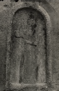 Fifth Assyrian (1922)
 Sixth Assyrian (1922)
 Sixth Assyrian (1922)
 Maundrell's depiction of the Assyrian stelae (1697)


.jpg)


_detail_1922.png)
_photo_1922.png)

 Roman (1780s)
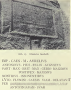 Roman (1922)
 Roman (1922)
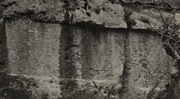 Barquq (1922)
.jpg)


_photo_1922.png)
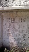 Napoleon III
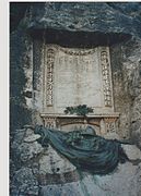 General Gouraud
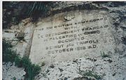 British troops capture Beirut and Tripoli (1918)
 Harry Chauvel (1918)
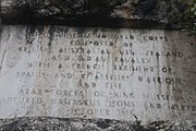 Capture of Damascus, Homs and Aleppo (1918)
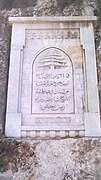 Bechara El Khoury, Lebanese independence (1946)
 Departure of Israeli troops from Lebanon (2000)


