Photos • Location
Coishco | |
|---|---|
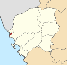
 Location of Coishco in the
Santa province | |
| Country | |
| Region | Ancash |
| Province | Santa |
| Founded | December 13, 1988 |
| Capital | Coishco |
| Area | |
| • Total | 9.21 km2 (3.56 sq mi) |
| Elevation | 15 m (49 ft) |
| Population (
2005 census) | |
| • Total | 15,036 |
| • Density | 1,600/km2 (4,200/sq mi) |
| Time zone | UTC-5 ( PET) |
| UBIGEO | 021803 |
Coishco District is one of nine districts of the Santa Province in Peru. [1]
References
- ^ (in Spanish) Instituto Nacional de Estadística e Informática. Banco de Información Distrital Archived April 23, 2008, at the Wayback Machine. Retrieved April 11, 2008.
9°01′23″S 78°36′56″W / 9.02306°S 78.61556°W
Coishco | |
|---|---|
 Location of Coishco in the
Santa province | |
| Country | |
| Region | Ancash |
| Province | Santa |
| Founded | December 13, 1988 |
| Capital | Coishco |
| Area | |
| • Total | 9.21 km2 (3.56 sq mi) |
| Elevation | 15 m (49 ft) |
| Population (
2005 census) | |
| • Total | 15,036 |
| • Density | 1,600/km2 (4,200/sq mi) |
| Time zone | UTC-5 ( PET) |
| UBIGEO | 021803 |
Coishco District is one of nine districts of the Santa Province in Peru. [1]
References
- ^ (in Spanish) Instituto Nacional de Estadística e Informática. Banco de Información Distrital Archived April 23, 2008, at the Wayback Machine. Retrieved April 11, 2008.
9°01′23″S 78°36′56″W / 9.02306°S 78.61556°W