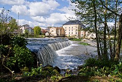
| Clain | |
|---|---|
 | |
 | |
| Location | |
| Country | France |
| Physical characteristics | |
| Source | |
| • location | Poitou |
| Mouth | |
• location | Vienne |
• coordinates | 46°46′52″N 0°32′26″E / 46.78111°N 0.54056°E |
| Length | 144 km (89 mi) |
| Basin size | 3,145 km2 (1,214 sq mi) |
| Basin features | |
| Progression | Vienne→ Loire→ Atlantic Ocean |

The Clain (French pronunciation: [klɛ̃]; Occitan: Clen) is a 144 km (89 mi) long river in western France, a left tributary of the river Vienne. [1] Its source is near Hiesse, Charente.
The Clain flows generally north, through the following departments and towns:
It joins the Vienne near Châtellerault, Cenon-sur-Vienne.
Among its tributaries are the Boivre, the Clouère and the Vonne.
References
| Clain | |
|---|---|
 | |
 | |
| Location | |
| Country | France |
| Physical characteristics | |
| Source | |
| • location | Poitou |
| Mouth | |
• location | Vienne |
• coordinates | 46°46′52″N 0°32′26″E / 46.78111°N 0.54056°E |
| Length | 144 km (89 mi) |
| Basin size | 3,145 km2 (1,214 sq mi) |
| Basin features | |
| Progression | Vienne→ Loire→ Atlantic Ocean |

The Clain (French pronunciation: [klɛ̃]; Occitan: Clen) is a 144 km (89 mi) long river in western France, a left tributary of the river Vienne. [1] Its source is near Hiesse, Charente.
The Clain flows generally north, through the following departments and towns:
It joins the Vienne near Châtellerault, Cenon-sur-Vienne.
Among its tributaries are the Boivre, the Clouère and the Vonne.
References